<< Text Pages >> Priest Lake Pictographs - Rock Art in United States in The Northwest Mountains
Submitted by bat400 on Tuesday, 13 November 2018 Page Views: 3621
Rock ArtSite Name: Priest Lake PictographsCountry: United States Region: The Northwest Mountains Type: Rock Art
Nearest Town: Spokane, WA Nearest Village: Coolin, ID
Latitude: 48.570000N Longitude: 116.87W
Condition:
| 5 | Perfect |
| 4 | Almost Perfect |
| 3 | Reasonable but with some damage |
| 2 | Ruined but still recognisable as an ancient site |
| 1 | Pretty much destroyed, possibly visible as crop marks |
| 0 | No data. |
| -1 | Completely destroyed |
| 5 | Superb |
| 4 | Good |
| 3 | Ordinary |
| 2 | Not Good |
| 1 | Awful |
| 0 | No data. |
| 5 | Can be driven to, probably with disabled access |
| 4 | Short walk on a footpath |
| 3 | Requiring a bit more of a walk |
| 2 | A long walk |
| 1 | In the middle of nowhere, a nightmare to find |
| 0 | No data. |
| 5 | co-ordinates taken by GPS or official recorded co-ordinates |
| 4 | co-ordinates scaled from a detailed map |
| 3 | co-ordinates scaled from a bad map |
| 2 | co-ordinates of the nearest village |
| 1 | co-ordinates of the nearest town |
| 0 | no data |
Internal Links:
External Links:
Rock Art in Bonner County, Idaho.
Pictographs in Idaho are mainly found north of the Snake River. Priest Lake Indian Pictographs which can be toured by boat. Thought to have been made by the Kalispel tribe, in the time around and immediately prior to contact with Europeans.
"These images are of vast historical significance due to their evolutionary recording of local eating habits, tribe interactions, and hunting practices."
The location given is for Priest Lake State Park, and not for the rock art itself. See the National Forest Service website and a website for several lake businesses for more information.
You may be viewing yesterday's version of this page. To see the most up to date information please register for a free account.
")
")
Do not use the above information on other web sites or publications without permission of the contributor.
Nearby Images from Flickr

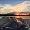
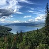
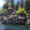
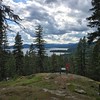
The above images may not be of the site on this page, but were taken nearby. They are loaded from Flickr so please click on them for image credits.
Click here to see more info for this site
Nearby sites
Click here to view sites on an interactive map of the areaKey: Red: member's photo, Blue: 3rd party photo, Yellow: other image, Green: no photo - please go there and take one, Grey: site destroyed
Download sites to:
KML (Google Earth)
GPX (GPS waypoints)
CSV (Garmin/Navman)
CSV (Excel)
To unlock full downloads you need to sign up as a Contributory Member. Otherwise downloads are limited to 50 sites.
Turn off the page maps and other distractions
Nearby sites listing. In the following links * = Image available
99.1km SSW 208° Indian Painted Rocks (Spokane) Rock Art
147.5km E 80° Crystal Lakes Golf Course Stonehenge* Modern Stone Circle etc
188.1km W 260° Balance Rock Omak* Natural Stone / Erratic / Other Natural Feature
248.3km S 183° Red Elk Rock Shelter* Rock Art
265.9km ENE 60° Head-Smashed-In Buffalo Jump* Ancient Mine, Quarry or other Industry
295.5km SW 234° Vantage Petroglyphs* Rock Art
298.4km S 173° Cooper's Ferry Archaeological Site* Ancient Village or Settlement
311.2km NE 39° Big Rock (Alberta) Rock Art
312.3km SW 228° Whale Island Petroglyphs Rock Art
312.7km SW 214° Columbia Park* Ancient Village or Settlement
344.2km ENE 59° Sundial Medicine Wheel* Ring Cairn
344.5km NE 34° Ootssip'tomowa Look Out Hill* Hill Figure or Geoglyph
348.9km SSW 213° Matalam Ancient Village or Settlement
359.6km S 177° Snake River Archaeological Site* Rock Art
388.7km E 80° Writing-on-Stone Provincial Park* Rock Art
391.0km ENE 66° Fincastle Grazing Reserve Bison Kill* Ancient Mine, Quarry or other Industry
391.8km NE 53° Majorville Medicine Wheel* Round Cairn
392.3km W 280° Sumas Lightning Rock* Natural Stone / Erratic / Other Natural Feature
398.8km WNW 281° Xaytem Ancient Native Settlement* Ancient Village or Settlement
398.9km N 0° Cataract Creek Petroglyphs* Rock Art
399.5km S 180° Hells Canyon Archeological District* Rock Art
415.5km ESE 105° First Peoples Buffalo Jump* Natural Stone / Erratic / Other Natural Feature
416.2km WSW 258° Burke Museum of Natural History and Culture* Museum
427.2km WSW 250° Skystone* Natural Stone / Erratic / Other Natural Feature
431.4km W 259° Haleets* Rock Art
View more nearby sites and additional images


 We would like to know more about this location. Please feel free to add a brief description and any relevant information in your own language.
 Wir möchten mehr über diese Stätte erfahren. Bitte zögern Sie nicht, eine kurze Beschreibung und relevante Informationen in Deutsch hinzuzufügen.
 Nous aimerions en savoir encore un peu sur les lieux. S'il vous plaît n'hesitez pas à ajouter une courte description et tous les renseignements pertinents dans votre propre langue.
 Quisieramos informarnos un poco más de las lugares. No dude en añadir una breve descripción y otros datos relevantes en su propio idioma.