


<< Our Photo Pages >> Little Black Mountain - Rock Art in United States in The Southwest
Submitted by mfrincu on Sunday, 31 May 2015 Page Views: 3119
Rock ArtSite Name: Little Black MountainCountry: United States
NOTE: This site is 36.447 km away from the location you searched for.
Region: The Southwest Type: Rock Art
Nearest Town: St. George, Utah
Latitude: 36.994722N Longitude: 113.499444W
Condition:
| 5 | Perfect |
| 4 | Almost Perfect |
| 3 | Reasonable but with some damage |
| 2 | Ruined but still recognisable as an ancient site |
| 1 | Pretty much destroyed, possibly visible as crop marks |
| 0 | No data. |
| -1 | Completely destroyed |
| 5 | Superb |
| 4 | Good |
| 3 | Ordinary |
| 2 | Not Good |
| 1 | Awful |
| 0 | No data. |
| 5 | Can be driven to, probably with disabled access |
| 4 | Short walk on a footpath |
| 3 | Requiring a bit more of a walk |
| 2 | A long walk |
| 1 | In the middle of nowhere, a nightmare to find |
| 0 | No data. |
| 5 | co-ordinates taken by GPS or official recorded co-ordinates |
| 4 | co-ordinates scaled from a detailed map |
| 3 | co-ordinates scaled from a bad map |
| 2 | co-ordinates of the nearest village |
| 1 | co-ordinates of the nearest town |
| 0 | no data |
Internal Links:
External Links:
")
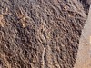
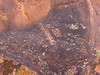
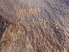
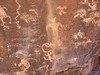
The different designs are associated with the cultures of the Great Basin, Western Anasazi, and Lower Colorado River. Some interpretive panels are located on site.
The site is 10 miles southeast of St. George, Utah. From St. George, travel south on Interstate 15 to Southern Parkway. Travel east on Southern Parkway for three miles to the River Road Exit, which is located at the Utah-Arizona state line. Take Quail Hill Road (BLM Road 1069) one-quarter mile south from the Utah-Arizona state line, turn left (east) and follow the signs 4.5 miles to the site.
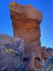
Special features include an extensive petroglyph site, created by the Western Anasazi, Great Basin, and Lower Colorado River natives at the base of dark red colored cliffs. The site contains at least one winter solstice alignment that can be viewed at sunrise on December 21 when the rising sun shoots through a crevice in the rocks and crosses a circular glyph.
Source: extract of the official website: http://www.blm.gov/az/st/en/prog/cultural/lil-blk-mtn.html
You may be viewing yesterday's version of this page. To see the most up to date information please register for a free account.
")
")
Do not use the above information on other web sites or publications without permission of the contributor.
Nearby Images from Flickr
The above images may not be of the site on this page, but were taken nearby. They are loaded from Flickr so please click on them for image credits.
Click here to see more info for this site
Nearby sites
Click here to view sites on an interactive map of the areaKey: Red: member's photo, Blue: 3rd party photo, Yellow: other image, Green: no photo - please go there and take one, Grey: site destroyed
Download sites to:
KML (Google Earth)
GPX (GPS waypoints)
CSV (Garmin/Navman)
CSV (Excel)
To unlock full downloads you need to sign up as a Contributory Member. Otherwise downloads are limited to 50 sites.
Turn off the page maps and other distractions
Nearby sites listing. In the following links * = Image available
11.2km NW 323° Fort Pearce Wash Petroglyphs* Rock Art
12.2km WNW 302° Bloomington Petroglyph Park* Rock Art
24.0km NW 316° Land Hill Petroglyphs* Rock Art
24.6km ESE 118° Antelope Cave Cave or Rock Shelter
83.5km E 84° Dupont Cave* Cave or Rock Shelter
109.6km SW 236° Mouse's Tank Canyon* Natural Stone / Erratic / Other Natural Feature
113.2km SW 236° Valley of Fire - Atlatl Rock* Rock Art
151.6km SW 236° Gypsum Cave Cave or Rock Shelter
159.6km SE 130° Bright Angel Trail* Rock Art
169.3km E 94° Glen Canyon - Descending Sheep Panel Petroglyph Site* Rock Art
182.1km ENE 61° North Creek Shelter Cave or Rock Shelter
182.3km SE 126° Tusayan Ruins* Ancient Village or Settlement
184.8km SW 230° Sloan Petroglyph Site* Rock Art
196.9km WSW 242° Lost Creek* Rock Art
203.6km NNE 30° Fremont Indian State Park* Museum
205.7km ESE 118° Tutuveni* Rock Art
209.7km ENE 60° Anasazi Indian State Park* Ancient Village or Settlement
223.6km SSW 209° Grapevine Canyon* Rock Art
233.6km NNW 347° Baker Archaeological Site* Ancient Village or Settlement
233.7km SE 145° Keyhole Sink* Rock Art
240.6km SE 130° Lomaki Pueblo Ancient Village or Settlement
240.7km SE 130° Box Canyon Pueblo Ancient Village or Settlement
241.4km SE 131° Citadel Pueblo Ancient Village or Settlement
242.5km NNE 21° Devil's Kitchen Area Rock Art
245.3km NE 53° Fruita Petroglyphs* Rock Art
View more nearby sites and additional images


 We would like to know more about this location. Please feel free to add a brief description and any relevant information in your own language.
 Wir möchten mehr über diese Stätte erfahren. Bitte zögern Sie nicht, eine kurze Beschreibung und relevante Informationen in Deutsch hinzuzufügen.
 Nous aimerions en savoir encore un peu sur les lieux. S'il vous plaît n'hesitez pas à ajouter une courte description et tous les renseignements pertinents dans votre propre langue.
 Quisieramos informarnos un poco más de las lugares. No dude en añadir una breve descripción y otros datos relevantes en su propio idioma.