<< Text Pages >> Quarry of the Ancestors - Ancient Mine, Quarry or other Industry in Canada
Submitted by bat400 on Friday, 15 September 2006 Page Views: 13361
Multi-periodSite Name: Quarry of the AncestorsCountry: Canada Type: Ancient Mine, Quarry or other Industry
Nearest Town: Fort McKay, Alberta
Latitude: 57.260000N Longitude: 111.538W
Condition:
| 5 | Perfect |
| 4 | Almost Perfect |
| 3 | Reasonable but with some damage |
| 2 | Ruined but still recognisable as an ancient site |
| 1 | Pretty much destroyed, possibly visible as crop marks |
| 0 | No data. |
| -1 | Completely destroyed |
| 5 | Superb |
| 4 | Good |
| 3 | Ordinary |
| 2 | Not Good |
| 1 | Awful |
| 0 | No data. |
| 5 | Can be driven to, probably with disabled access |
| 4 | Short walk on a footpath |
| 3 | Requiring a bit more of a walk |
| 2 | A long walk |
| 1 | In the middle of nowhere, a nightmare to find |
| 0 | No data. |
| 5 | co-ordinates taken by GPS or official recorded co-ordinates |
| 4 | co-ordinates scaled from a detailed map |
| 3 | co-ordinates scaled from a bad map |
| 2 | co-ordinates of the nearest village |
| 1 | co-ordinates of the nearest town |
| 0 | no data |
Be the first person to rate this site - see the 'Contribute!' box in the right hand menu.
Internal Links:
External Links:
Ancient Quarry in Alberta. The site occupation dates to 12,000 BC and was used for thousands of years. Paleo-Indian period stone tools fashioned from what has been known as "Beaver River Sandstone" are now known to have come from this location, just north-east of the modern town of Fort McKay. These tools were traded throughout northern Alberta and Saskatchewan.
The site was discovered in 2003 in a standard archaeological survey conducted by the Birch Mountain Resources mining company. The find resulted in mining operations being moved from the area, which covers more than a square kilometer. The location given is aproximate. Note the modern quarry areas surrounding it in the Flash Earth view.)
[Information from the Toronto Star from the Canadian Press wire service, and the Birch Mountain Resources webpages. The land is owned by the Fort Mackay First Nation who lease the mining rights to Birch Hills Resources (associated with Birch Mountain.) Cooperation between the parties seems aimed to perserve the site free from mining operation and conduct digs to learn more about the original "miners."]
The site is now on the Alberta Register of Historic Places, which preserves it from industrial and residential development. https://hermis.alberta.ca/ARHP
Note: New discoveries reported, see comment
You may be viewing yesterday's version of this page. To see the most up to date information please register for a free account.
Do not use the above information on other web sites or publications without permission of the contributor.
Nearby Images from Flickr


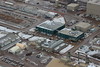
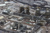
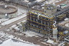
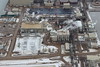
The above images may not be of the site on this page, but were taken nearby. They are loaded from Flickr so please click on them for image credits.
Click here to see more info for this site
Nearby sites
Click here to view sites on an interactive map of the areaKey: Red: member's photo, Blue: 3rd party photo, Yellow: other image, Green: no photo - please go there and take one, Grey: site destroyed
Download sites to:
KML (Google Earth)
GPX (GPS waypoints)
CSV (Garmin/Navman)
CSV (Excel)
To unlock full downloads you need to sign up as a Contributory Member. Otherwise downloads are limited to 50 sites.
Turn off the page maps and other distractions
Nearby sites listing. In the following links * = Image available
456.3km ESE 119° Lac La Ronge Rock Art Rock Art
643.2km SSE 148° Wanuskewin Heritage Park* Museum
662.3km SSW 213° Cataract Creek Petroglyphs* Rock Art
704.7km SSW 195° Ootssip'tomowa Look Out Hill* Hill Figure or Geoglyph
744.4km S 185° Majorville Medicine Wheel* Round Cairn
747.3km SSW 194° Big Rock (Alberta) Rock Art
775.7km ESE 117° Kapakoskasewakak Lake stones Stone Row / Alignment
799.0km S 186° Sundial Medicine Wheel* Ring Cairn
807.0km S 176° Saami Giant Teepee* Ancient Village or Settlement
810.4km WSW 247° Beaverly Workshop Ancient Mine, Quarry or other Industry
817.1km S 182° Fincastle Grazing Reserve Bison Kill* Ancient Mine, Quarry or other Industry
849.3km S 173° Stampede Site* Ancient Mine, Quarry or other Industry
851.4km S 190° Head-Smashed-In Buffalo Jump* Ancient Mine, Quarry or other Industry
909.4km S 180° Writing-on-Stone Provincial Park* Rock Art
968.3km SSW 195° Crystal Lakes Golf Course Stonehenge* Modern Stone Circle etc
1018.9km W 264° 'Ksan Historical Village and Museum* Museum
1029.6km SSW 202° Priest Lake Pictographs Rock Art
1087.6km S 180° First Peoples Buffalo Jump* Natural Stone / Erratic / Other Natural Feature
1111.2km WSW 247° Nuxalk Petroglyphs Rock Art
1127.3km SSW 203° Indian Painted Rocks (Spokane) Rock Art
1131.8km SSW 211° Balance Rock Omak* Natural Stone / Erratic / Other Natural Feature
1147.1km SW 223° Xaytem Ancient Native Settlement* Ancient Village or Settlement
1152.2km SW 222° Sumas Lightning Rock* Natural Stone / Erratic / Other Natural Feature
1168.8km SW 229° Salmon Inlet Barrow Cemetery
1170.3km SW 226° Xwayzway Village* Ancient Village or Settlement
View more nearby sites and additional images


 We would like to know more about this location. Please feel free to add a brief description and any relevant information in your own language.
 Wir möchten mehr über diese Stätte erfahren. Bitte zögern Sie nicht, eine kurze Beschreibung und relevante Informationen in Deutsch hinzuzufügen.
 Nous aimerions en savoir encore un peu sur les lieux. S'il vous plaît n'hesitez pas à ajouter une courte description et tous les renseignements pertinents dans votre propre langue.
 Quisieramos informarnos un poco más de las lugares. No dude en añadir una breve descripción y otros datos relevantes en su propio idioma.