


<< Our Photo Pages >> Falling Block - Natural Stone / Erratic / Other Natural Feature in United States in The Northwest Mountains
Submitted by AKFisher on Saturday, 04 May 2024 Page Views: 26
Natural PlacesSite Name: Falling Block Alternative Name: Falling Rock, Wyoming CubeCountry: United States
NOTE: This site is 53.248 km away from the location you searched for.
Region: The Northwest Mountains Type: Natural Stone / Erratic / Other Natural Feature
Nearest Town: Burgess, WY
Latitude: 44.721170N Longitude: 107.5499W
Condition:
| 5 | Perfect |
| 4 | Almost Perfect |
| 3 | Reasonable but with some damage |
| 2 | Ruined but still recognisable as an ancient site |
| 1 | Pretty much destroyed, possibly visible as crop marks |
| 0 | No data. |
| -1 | Completely destroyed |
| 5 | Superb |
| 4 | Good |
| 3 | Ordinary |
| 2 | Not Good |
| 1 | Awful |
| 0 | No data. |
| 5 | Can be driven to, probably with disabled access |
| 4 | Short walk on a footpath |
| 3 | Requiring a bit more of a walk |
| 2 | A long walk |
| 1 | In the middle of nowhere, a nightmare to find |
| 0 | No data. |
| 5 | co-ordinates taken by GPS or official recorded co-ordinates |
| 4 | co-ordinates scaled from a detailed map |
| 3 | co-ordinates scaled from a bad map |
| 2 | co-ordinates of the nearest village |
| 1 | co-ordinates of the nearest town |
| 0 | no data |
Internal Links:
External Links:
")
That said, long striations on the eastern face of the cube appear to be man-made and resemble similar rock work in quarries and tunneling. The top of the cube is similarly squared and appears to be made by human hands. There is little information on Falling Block as it is in a nearly inaccessible area with a steep hike of over 4 miles to the area called "Bear Rocks." It has only been visited in the past few years by some intrepid hikers and a few climbing enthusiasts. The question remains ~ Man-Made or Natural?
Further information and links:
1. The Ancient Connection: http://www.theancientconnection.com/megaliths/north-america/wyoming-falling-block-natural-or-artificial/
2. Wake Up Wyoming: wakeupwyo.com/the-odd-orgions-of-wyomings-mysterious-massive-cube/
3. GeoWyo.com: http://www.geowyo.com/bighorn-mountain-byways-part-i.html (scroll down to near bottom of page)
Directions: Best directions on GeoWyo link above.
You may be viewing yesterday's version of this page. To see the most up to date information please register for a free account.
")
")
Do not use the above information on other web sites or publications without permission of the contributor.
Nearby Images from Flickr

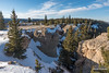


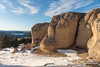
The above images may not be of the site on this page, but were taken nearby. They are loaded from Flickr so please click on them for image credits.
Click here to see more info for this site
Nearby sites
Click here to view sites on an interactive map of the areaKey: Red: member's photo, Blue: 3rd party photo, Yellow: other image, Green: no photo - please go there and take one, Grey: site destroyed
Download sites to:
KML (Google Earth)
GPX (GPS waypoints)
CSV (Garmin/Navman)
CSV (Excel)
To unlock full downloads you need to sign up as a Contributory Member. Otherwise downloads are limited to 50 sites.
Turn off the page maps and other distractions
Nearby sites listing. In the following links * = Image available
31.6km WNW 292° Bighorn Medicine Wheel* Stone Circle
47.0km S 179° Medicine Lodge State Archeological Site* Rock Art
81.7km WNW 293° Petroglyph Canyon (Cowley)* Rock Art
127.7km WNW 303° Valley of the Shields* Rock Art
132.3km SW 220° Legend Rock* Rock Art
132.4km NNW 329° Pictograph Caves* Rock Art
175.5km W 261° Mummy Cave* Cave or Rock Shelter
199.3km S 181° Castle Gardens* Rock Art
219.9km SW 230° High Rise Village Ancient Village or Settlement
225.1km W 263° Yellowstone Lake* Ancient Village or Settlement
225.9km E 93° Devil's Tower National Monument* Natural Stone / Erratic / Other Natural Feature
230.9km E 100° Arch Creek Petroglyphs* Rock Art
245.8km SSE 148° Glenrock Buffalo Jump* Natural Stone / Erratic / Other Natural Feature
251.1km W 274° Obsidian Cliff* Ancient Mine, Quarry or other Industry
269.3km E 93° Vore Buffalo Jump* Natural Stone / Erratic / Other Natural Feature
343.9km SSW 204° White Mountain Wyoming* Rock Art
348.8km SE 137° Hell Gap* Ancient Village or Settlement
380.5km ESE 122° Hudson-Meng Bison Kill* Ancient Mine, Quarry or other Industry
397.3km WNW 302° Megaliths Of Helena* Natural Stone / Erratic / Other Natural Feature
433.5km NW 316° First Peoples Buffalo Jump* Natural Stone / Erratic / Other Natural Feature
462.8km SSE 153° Lindenmeier Site* Ancient Mine, Quarry or other Industry
475.0km SE 125° Carhenge, Nebraska* Modern Stone Circle etc
479.0km SSW 195° Dinosaur National Monument* Rock Art
551.0km SW 229° Great Salt Lake Cave* Cave or Rock Shelter
570.3km WSW 255° Shoshone Ice Caves* Cave or Rock Shelter
View more nearby sites and additional images


 We would like to know more about this location. Please feel free to add a brief description and any relevant information in your own language.
 Wir möchten mehr über diese Stätte erfahren. Bitte zögern Sie nicht, eine kurze Beschreibung und relevante Informationen in Deutsch hinzuzufügen.
 Nous aimerions en savoir encore un peu sur les lieux. S'il vous plaît n'hesitez pas à ajouter une courte description et tous les renseignements pertinents dans votre propre langue.
 Quisieramos informarnos un poco más de las lugares. No dude en añadir una breve descripción y otros datos relevantes en su propio idioma.