

<< Our Photo Pages >> Badger Hole (Oklahoma) - Ancient Mine, Quarry or other Industry in United States in The Plains
Submitted by bat400 on Wednesday, 27 August 2014 Page Views: 17719
Multi-periodSite Name: Badger Hole (Oklahoma)Country: United States
NOTE: This site is 130.452 km away from the location you searched for.
Region: The Plains Type: Ancient Mine, Quarry or other Industry
Nearest Town: Woodward, OK Nearest Village: Fort Supply, OK
Latitude: 36.570000N Longitude: 99.57W
Condition:
| 5 | Perfect |
| 4 | Almost Perfect |
| 3 | Reasonable but with some damage |
| 2 | Ruined but still recognisable as an ancient site |
| 1 | Pretty much destroyed, possibly visible as crop marks |
| 0 | No data. |
| -1 | Completely destroyed |
| 5 | Superb |
| 4 | Good |
| 3 | Ordinary |
| 2 | Not Good |
| 1 | Awful |
| 0 | No data. |
| 5 | Can be driven to, probably with disabled access |
| 4 | Short walk on a footpath |
| 3 | Requiring a bit more of a walk |
| 2 | A long walk |
| 1 | In the middle of nowhere, a nightmare to find |
| 0 | No data. |
| 5 | co-ordinates taken by GPS or official recorded co-ordinates |
| 4 | co-ordinates scaled from a detailed map |
| 3 | co-ordinates scaled from a bad map |
| 2 | co-ordinates of the nearest village |
| 1 | co-ordinates of the nearest town |
| 0 | no data |
Be the first person to rate this site - see the 'Contribute!' box in the right hand menu.
Internal Links:
External Links:
I have visited· I would like to visit
bat400 would like to visit
 (PID:91087)")
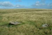
Folsom points have been found in the bone bed. Excavation project leader Lee Bement (Oklahoma Archaeological Survey) is looking for any cultural artifact remains that may shed light on this period, when climate warming appears to have had a partial to major impact on species extinction and the rise of new species, including the modern bison (Bison bison.)
Excavations continue to 2012.
The location given is for one of the closest population centers, Fort Supply. The location given is not the Badger Hole site itself.
Note: Pining for some Time Team? The American version visits Badger Hole and Dillard 'Lost Pueblo Village' - watch online from anywhere in the world.
You may be viewing yesterday's version of this page. To see the most up to date information please register for a free account.
Do not use the above information on other web sites or publications without permission of the contributor.
Nearby Images from Flickr


The above images may not be of the site on this page, but were taken nearby. They are loaded from Flickr so please click on them for image credits.
Click here to see more info for this site
Nearby sites
Click here to view sites on an interactive map of the areaKey: Red: member's photo, Blue: 3rd party photo, Yellow: other image, Green: no photo - please go there and take one, Grey: site destroyed
Download sites to:
KML (Google Earth)
GPX (GPS waypoints)
CSV (Garmin/Navman)
CSV (Excel)
To unlock full downloads you need to sign up as a Contributory Member. Otherwise downloads are limited to 50 sites.
Turn off the page maps and other distractions
Nearby sites listing. In the following links * = Image available
231.0km ENE 76° Etzanoa* Ancient Village or Settlement
284.7km W 279° Crack Cave Rock Art
286.9km W 281° Picture Canyon* Rock Art
359.7km WNW 289° Pinon Canyon Rock Art
409.8km E 91° Spavinaw Creek Ancient Village or Settlement
424.9km SW 234° Blackwater Draw* Museum
445.9km NE 50° Truckhenge* Modern Stone Circle etc
456.6km SSE 149° The Flower Mound Natural Stone / Erratic / Other Natural Feature
471.4km ESE 106° Spiro Mounds Archaeological Park* Ancient Village or Settlement
481.5km SSE 151° Caelum Moor* Modern Stone Circle etc
484.6km ESE 105° Cavanaugh* Artificial Mound
487.2km ESE 111° Heavener Rune Stone* Carving
515.2km E 82° Horseshoe Fossil Spring Ancient Village or Settlement
528.6km ENE 74° Big Eddy* Ancient Mine, Quarry or other Industry
534.2km W 270° Taos Pueblo* Ancient Village or Settlement
540.6km WNW 302° U.S. Air Force Academy Modern Stone Circle Modern Stone Circle etc
578.6km SSW 207° UTPB Stonehenge Replica* Modern Stone Circle etc
595.9km SE 134° Kelsey Creek Dam site Ancient Village or Settlement
599.6km ESE 116° Ka-Do-Ha* Museum
600.4km W 266° Puye Cliff Dwellings* Cave or Rock Shelter
607.7km W 264° Bandelier National Monument* Ancient Village or Settlement
608.0km W 264° Bandelier National Mounument - Tyuonyi* Ancient Village or Settlement
608.1km W 264° Bandelier National Monument - Long House* Ancient Village or Settlement
608.8km W 264° Bandelier National Monument - Alcove House* Ancient Village or Settlement
620.1km ESE 103° Petit Jean State Park* Rock Art
View more nearby sites and additional images


 We would like to know more about this location. Please feel free to add a brief description and any relevant information in your own language.
 Wir möchten mehr über diese Stätte erfahren. Bitte zögern Sie nicht, eine kurze Beschreibung und relevante Informationen in Deutsch hinzuzufügen.
 Nous aimerions en savoir encore un peu sur les lieux. S'il vous plaît n'hesitez pas à ajouter une courte description et tous les renseignements pertinents dans votre propre langue.
 Quisieramos informarnos un poco más de las lugares. No dude en añadir una breve descripción y otros datos relevantes en su propio idioma.