<< Our Photo Pages >> Hoften's Cross - Early Christian Sculptured Stone in England in Staffordshire
Submitted by astronomer on Friday, 08 October 2004 Page Views: 6586
Early Medieval (Dark Age)Site Name: Hoften's CrossCountry: England
NOTE: This site is 2.067 km away from the location you searched for.
County: Staffordshire Type: Early Christian Sculptured Stone
Nearest Town: Cheadle Nearest Village: Cauldon
Map Ref: SK072481 Landranger Map Number: 119
Latitude: 53.030138N Longitude: 1.894093W
Condition:
| 5 | Perfect |
| 4 | Almost Perfect |
| 3 | Reasonable but with some damage |
| 2 | Ruined but still recognisable as an ancient site |
| 1 | Pretty much destroyed, possibly visible as crop marks |
| 0 | No data. |
| -1 | Completely destroyed |
| 5 | Superb |
| 4 | Good |
| 3 | Ordinary |
| 2 | Not Good |
| 1 | Awful |
| 0 | No data. |
| 5 | Can be driven to, probably with disabled access |
| 4 | Short walk on a footpath |
| 3 | Requiring a bit more of a walk |
| 2 | A long walk |
| 1 | In the middle of nowhere, a nightmare to find |
| 0 | No data. |
| 5 | co-ordinates taken by GPS or official recorded co-ordinates |
| 4 | co-ordinates scaled from a detailed map |
| 3 | co-ordinates scaled from a bad map |
| 2 | co-ordinates of the nearest village |
| 1 | co-ordinates of the nearest town |
| 0 | no data |
Internal Links:
External Links:
I have visited· I would like to visit
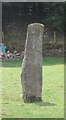
BrownEdger visited on 1st Jun 2013 - their rating: Cond: 3 Amb: 3 Access: 5 Visible from the road and the car park of The Cross pub across the road. A footpath enters the field where Hoften's Cross is located. The close proximity of a stable made this not one of the more scenic spots. A shame that the pub sign has a crusader knight on it rather than this rude cross!
")
A 'rude' cross, possibly a re-used prehistoric, standing stone located near Caldon Low quarries at a crossroads called Hoften's Cross. There is a pub called the Cross (or something similar) over the road from this 2.5m standing stone, map ref SK072481 on the OS Explorer 259, Derby, Uttoxeter, Ashbourne & Cheadle map.
You may be viewing yesterday's version of this page. To see the most up to date information please register for a free account.
")
")
Do not use the above information on other web sites or publications without permission of the contributor.
Runemage has found this location on Google Street View:
Nearby Images from Geograph Britain and Ireland:
©2019(licence)
©2008(licence)
©2006(licence)
©2007(licence)
©2008(licence)
The above images may not be of the site on this page, they are loaded from Geograph.
Please Submit an Image of this site or go out and take one for us!
Click here to see more info for this site
Nearby sites
Key: Red: member's photo, Blue: 3rd party photo, Yellow: other image, Green: no photo - please go there and take one, Grey: site destroyed
Download sites to:
KML (Google Earth)
GPX (GPS waypoints)
CSV (Garmin/Navman)
CSV (Excel)
To unlock full downloads you need to sign up as a Contributory Member. Otherwise downloads are limited to 50 sites.
Turn off the page maps and other distractions
Nearby sites listing. In the following links * = Image available
565m SE 135° Cauldon Lowe Barrow Cemetery (SK076477)
1.9km NW 305° Windywaycross* Early Christian Sculptured Stone (SK056492)
2.7km NNE 26° Stonesteads* Round Barrow(s) (SK08405052)
3.1km NNE 29° Lamber Low* Round Barrow(s) (SK08735085)
3.5km ESE 122° Weaver Hills* Barrow Cemetery (SK102462)
3.9km E 82° Caltonmoor* Round Barrow(s) (SK11084868)
4.0km WNW 296° Hopestone ; Ipstones/Foxt ; Staffordshire Natural Stone / Erratic / Other Natural Feature (SK0361049834)
4.1km ESE 103° Thorswood* Barrow Cemetery (SK112472)
4.4km ENE 72° Calton Round Barrow* Round Barrow(s) (SK114495)
4.4km NNE 19° Waterfall Low* Round Barrow(s) (SK08615231)
4.5km N 11° Grub Low* Round Barrow(s) (SK08045255)
4.9km ENE 75° Dun Low* Round Barrow(s) (SK119494)
4.9km ENE 66° Musden Low Cemetery* Barrow Cemetery (SK117501)
4.9km S 181° Bunbury Hillfort (Alton Towers)* Hillfort (SK07164318)
5.4km NNW 336° The Morridge Stone Circle (SK0553)
5.5km NNE 16° Mouse Low Round Barrow(s) (SK087534)
5.6km ENE 72° Hazleton Clump Cairn (SK125498)
5.8km E 80° Top Low 1 Round Barrow(s) (SK129491)
5.8km WNW 291° Ipstones tympanum* Early Christian Sculptured Stone (SK01785022)
6.0km NNE 32° Falcon Low Cave Cave or Rock Shelter (SK104532)
6.2km E 81° Top Low 2 Round Barrow(s) (SK133491)
6.2km ENE 66° The Battle Stone (Ilam)* Ancient Cross (SK1286950579)
6.5km ENE 68° St Bertram's Well (Ilam)* Holy Well or Sacred Spring (SK13275059)
6.5km NNE 12° All Saints (Grindon) Early Christian Sculptured Stone (SK086545)
6.6km ENE 67° Church of the Holy Cross (Ilam)* Ancient Cross (SK1326950697)
View more nearby sites and additional images


 We would like to know more about this location. Please feel free to add a brief description and any relevant information in your own language.
 Wir möchten mehr über diese Stätte erfahren. Bitte zögern Sie nicht, eine kurze Beschreibung und relevante Informationen in Deutsch hinzuzufügen.
 Nous aimerions en savoir encore un peu sur les lieux. S'il vous plaît n'hesitez pas à ajouter une courte description et tous les renseignements pertinents dans votre propre langue.
 Quisieramos informarnos un poco más de las lugares. No dude en añadir una breve descripción y otros datos relevantes en su propio idioma.