<< Our Photo Pages >> St. Mary's Church (Brignall) - Ancient Cross in England in County Durham
Submitted by Anne T on Monday, 11 September 2017 Page Views: 1505
Early Medieval (Dark Age)Site Name: St. Mary''s Church (Brignall)Country: England
NOTE: This site is 1.487 km away from the location you searched for.
County: County Durham Type: Ancient Cross
Nearest Town: Barnard Castle Nearest Village: Brignall
Map Ref: NZ0725712313
Latitude: 54.506081N Longitude: 1.889441W
Condition:
| 5 | Perfect |
| 4 | Almost Perfect |
| 3 | Reasonable but with some damage |
| 2 | Ruined but still recognisable as an ancient site |
| 1 | Pretty much destroyed, possibly visible as crop marks |
| 0 | No data. |
| -1 | Completely destroyed |
| 5 | Superb |
| 4 | Good |
| 3 | Ordinary |
| 2 | Not Good |
| 1 | Awful |
| 0 | No data. |
| 5 | Can be driven to, probably with disabled access |
| 4 | Short walk on a footpath |
| 3 | Requiring a bit more of a walk |
| 2 | A long walk |
| 1 | In the middle of nowhere, a nightmare to find |
| 0 | No data. |
| 5 | co-ordinates taken by GPS or official recorded co-ordinates |
| 4 | co-ordinates scaled from a detailed map |
| 3 | co-ordinates scaled from a bad map |
| 2 | co-ordinates of the nearest village |
| 1 | co-ordinates of the nearest town |
| 0 | no data |
Internal Links:
External Links:
I have visited· I would like to visit
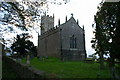
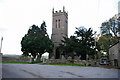
Anne T visited on 9th Sep 2017 - their rating: Cond: 3 Amb: 2 Access: 5 Cross base at St. Mary's New Church, Brignall (not found): After having visited the church in Barnard Castle and Barnard Castle, we set of to Brignall. According to Pastscape, there was a 13th century cross base sitting against the south-west corner of the tower of this church, together with a Roman altar and other stones. These used to be in the rectory gardens, but were re-sited in the churchyard.
No sign of the cross base or the altar existed, unless they are in this collection of stones, all of which are badly worn. These are located against the north west corner of the tower, behind the war memorial. There was nothing against the south west corner/south west wall of the church – I walked right round in case we’d missed anything, or they had been moved.
The church was locked at the time of our visit, so I couldn’t get inside to check if these artefacts had been moved inside for safety. As we parked up, a man in the house next to the church (to its right as photographed) was standing at the window looking at us, talking on the phone. He made no move to come out and talk to us, and made me feel like an intruder.
I will need to phone the Diocesan office to find out when the church is open and if the base and altar have been moved inside the church.
 (PID:170443)")
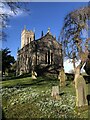
According to both Pastscape Monument No. 19963 and Monument No. 19960, the remains of a cross base sits against the south west wall of the church, together with a Roman altar. These were relocated from the gardens of the former rectory.
There is no sign of either the cross base or the Roman altar, unless they are either amongst the collection of stones against the north western corner of the tower, or have been moved inside the church for safe keeping. This collection of stones includes medieval grave covers and two half octagonal column bases; the inscription on the Roman altar is said to be too worn to read.
I will email the vicar to try and ascertain where these stones might be located and update this page once I know more - unless anyone else can help!
You may be viewing yesterday's version of this page. To see the most up to date information please register for a free account.
Do not use the above information on other web sites or publications without permission of the contributor.
Nearby Images from Geograph Britain and Ireland:

©2013(licence)
©2007(licence)
©2022(licence)
©2011(licence)
©2007(licence)
The above images may not be of the site on this page, they are loaded from Geograph.
Please Submit an Image of this site or go out and take one for us!
Click here to see more info for this site
Nearby sites
Key: Red: member's photo, Blue: 3rd party photo, Yellow: other image, Green: no photo - please go there and take one, Grey: site destroyed
Download sites to:
KML (Google Earth)
GPX (GPS waypoints)
CSV (Garmin/Navman)
CSV (Excel)
To unlock full downloads you need to sign up as a Contributory Member. Otherwise downloads are limited to 50 sites.
Turn off the page maps and other distractions
Nearby sites listing. In the following links * = Image available
480m ESE 104° St Mary's Old Church (Brignall)* Ancient Cross (NZ0772412196)
1.8km WSW 247° Brignall, Moor House Farm Rock Art (NZ0563011637)
1.9km ENE 70° Greta Bridge Roman Site Rock Art (NZ0905012950)
2.3km SE 146° St Michael & All Angels (Barningham)* Ancient Cross (NZ0853110448)
2.4km S 176° Barningham Moor 1. Rock Art (NZ0742809924)
2.4km S 174° Barningham Moor 96* Rock Art (NZ0749909926)
2.4km SSE 152° Barningham Modern Stone Circle* Modern Stone Circle etc (NZ084102)
2.6km S 175° Brown Hill (Barningham) Ancient Village or Settlement (NZ0749809706)
2.7km NE 47° The Mortham Stones Natural Stone / Erratic / Other Natural Feature (NZ09251415)
2.8km S 190° Grey Stones (Barningham Moor)* Ancient Village or Settlement (NZ0679209519)
2.8km S 189° Barningham Moor 97* Rock Art (NZ0680509501)
2.9km SSW 193° Cowclose House (Barningham Moor)* Ancient Village or Settlement (NZ0659309445)
3.0km NNW 338° Egglestone, Folly House Rock Art (NZ0614015070)
3.0km S 191° Barningham Moor 98* Rock Art (NZ0668509331)
3.1km NNW 338° Thorsgill Stone* Rock Art (NZ0608115200)
3.7km SSW 212° Barningham Moor 23* Rock Art (NZ0527609168)
3.9km SSW 207° Barningham Moor 20* Rock Art (NZ0546708808)
4.0km SSW 210° Barningham Moor 21 Rock Art (NZ0526708866)
4.0km SSW 210° Barningham Moor 19 Rock Art (NZ0529608846)
4.0km SSW 201° Barningham Moor 114* Rock Art (NZ0585808580)
4.0km S 184° Barningham Moor 116* Rock Art (NZ0696908335)
4.0km SSW 210° Barningham Moor 22 Rock Art (NZ0528208835)
4.0km S 186° Barningham Moor 115* Rock Art (NZ0685908311)
4.0km SSW 211° Barningham Moor 18 Rock Art (NZ0514508859)
4.1km SSW 212° Barningham Moor 16 Rock Art (NZ0509508874)
View more nearby sites and additional images


 We would like to know more about this location. Please feel free to add a brief description and any relevant information in your own language.
 Wir möchten mehr über diese Stätte erfahren. Bitte zögern Sie nicht, eine kurze Beschreibung und relevante Informationen in Deutsch hinzuzufügen.
 Nous aimerions en savoir encore un peu sur les lieux. S'il vous plaît n'hesitez pas à ajouter une courte description et tous les renseignements pertinents dans votre propre langue.
 Quisieramos informarnos un poco más de las lugares. No dude en añadir una breve descripción y otros datos relevantes en su propio idioma.