<< Our Photo Pages >> Rocester Church Cross (Rocester) - Ancient Cross in England in Staffordshire
Submitted by Anne T on Friday, 05 January 2018 Page Views: 996
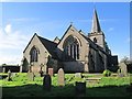
Early Medieval (Dark Age)Site Name: Rocester Church Cross (Rocester)Country: England
NOTE: This site is 2.814 km away from the location you searched for.
County: Staffordshire Type: Ancient Cross
Nearest Town: Uttoxeter Nearest Village: Rocester
Map Ref: SK1117039394
Latitude: 52.951811N Longitude: 1.835195W
Condition:
| 5 | Perfect |
| 4 | Almost Perfect |
| 3 | Reasonable but with some damage |
| 2 | Ruined but still recognisable as an ancient site |
| 1 | Pretty much destroyed, possibly visible as crop marks |
| 0 | No data. |
| -1 | Completely destroyed |
| 5 | Superb |
| 4 | Good |
| 3 | Ordinary |
| 2 | Not Good |
| 1 | Awful |
| 0 | No data. |
| 5 | Can be driven to, probably with disabled access |
| 4 | Short walk on a footpath |
| 3 | Requiring a bit more of a walk |
| 2 | A long walk |
| 1 | In the middle of nowhere, a nightmare to find |
| 0 | No data. |
| 5 | co-ordinates taken by GPS or official recorded co-ordinates |
| 4 | co-ordinates scaled from a detailed map |
| 3 | co-ordinates scaled from a bad map |
| 2 | co-ordinates of the nearest village |
| 1 | co-ordinates of the nearest town |
| 0 | no data |
Internal Links:
External Links:
 (PID:193626)")
The Northern Antiquarian (TNA) features a page for this cross - see their entry for Rocester Church Cross, Staffordshire, which gives directions for finding this site, together with an old image of the cross from the William Salt Library.
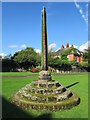
The cross is also recorded as Pastscape Monument No. 307302, which includes a photograph, reporting that this is: "the best preserved cross of the whole county (Staf)."
For the scheduling information see Historic England List ID 123192, which tells us this cross is on Dove Lane, "CROSS APPROXIMATELY 40 YARDS NORTH OF CHURCH OF ST MICHAEL ... Churchyard cross. C13. Stone. 4 Circular steps to 3-tier plinth with convex mouldings; quadrilobe shaft approximately 20 feet high with sunk dog-tooth ornament on 2 sides; the head is missing."
Note: Have you visited this site? Do you have any photographs or information to add?
You may be viewing yesterday's version of this page. To see the most up to date information please register for a free account.
 (PID:193628)")
 (PID:193627)")
Do not use the above information on other web sites or publications without permission of the contributor.
Nearby Images from Geograph Britain and Ireland:
©2017(licence)
©2020(licence)
©2023(licence)
©2023(licence)
©2017(licence)
The above images may not be of the site on this page, they are loaded from Geograph.
Please Submit an Image of this site or go out and take one for us!
Click here to see more info for this site
Nearby sites
Key: Red: member's photo, Blue: 3rd party photo, Yellow: other image, Green: no photo - please go there and take one, Grey: site destroyed
Download sites to:
KML (Google Earth)
GPX (GPS waypoints)
CSV (Garmin/Navman)
CSV (Excel)
To unlock full downloads you need to sign up as a Contributory Member. Otherwise downloads are limited to 50 sites.
Turn off the page maps and other distractions
Nearby sites listing. In the following links * = Image available
3.3km NNE 26° The Norbury Cross* Ancient Cross (SK126424)
5.2km S 180° St. Cuthbert's Well (Doveridge)* Holy Well or Sacred Spring (SK112342)
5.5km SSW 200° Pennycroft Well Holy Well or Sacred Spring (SK09293422)
5.5km NW 314° Bunbury Hillfort (Alton Towers)* Hillfort (SK07164318)
5.6km WSW 255° Toot Hill Barrow (1) Round Barrow(s) (SK05773797)
6.9km N 352° Weaver Hills* Barrow Cemetery (SK102462)
6.9km E 95° Bently Fields Farm* Modern Stone Circle etc (SK18093878)
7.0km SSW 194° Maiden's Well* Holy Well or Sacred Spring (SK09493264)
7.6km S 188° Toot Hill Barrow (2)* Round Barrow(s) (SK10143184)
7.8km N 0° Thorswood* Barrow Cemetery (SK112472)
8.5km NE 55° Wyaston Road 1* Round Barrow(s) (SK181443)
8.5km W 260° St Mary and All Saints (Checkley)* Ancient Cross (SK02783787)
8.9km NE 53° Wyaston Road 2* Round Barrow(s) (SK183447)
9.0km NNW 337° Cauldon Lowe Barrow Cemetery (SK076477)
9.3km N 360° Caltonmoor* Round Barrow(s) (SK11084868)
9.6km NNW 336° Hoften's Cross* Early Christian Sculptured Stone (SK072481)
9.6km NE 43° St Oswald (Ashbourne)* Ancient Cross (SK1765546480)
9.9km N 10° Top Low 1 Round Barrow(s) (SK129491)
9.9km NNE 12° Top Low 2 Round Barrow(s) (SK133491)
10.0km N 4° Dun Low* Round Barrow(s) (SK119494)
10.1km N 1° Calton Round Barrow* Round Barrow(s) (SK114495)
10.5km N 7° Hazleton Clump Cairn (SK125498)
10.6km NNE 14° Lady Low Round Barrow(s) (SK138497)
10.6km NNE 14° Barrow near Lady Low Round Barrow(s) (SK138497)
10.7km N 3° Musden Low Cemetery* Barrow Cemetery (SK117501)
View more nearby sites and additional images


 We would like to know more about this location. Please feel free to add a brief description and any relevant information in your own language.
 Wir möchten mehr über diese Stätte erfahren. Bitte zögern Sie nicht, eine kurze Beschreibung und relevante Informationen in Deutsch hinzuzufügen.
 Nous aimerions en savoir encore un peu sur les lieux. S'il vous plaît n'hesitez pas à ajouter une courte description et tous les renseignements pertinents dans votre propre langue.
 Quisieramos informarnos un poco más de las lugares. No dude en añadir una breve descripción y otros datos relevantes en su propio idioma.