<< Our Photo Pages >> Legg's Cross - Ancient Cross in England in County Durham
Submitted by Anne T on Monday, 24 August 2015 Page Views: 5472
Early Medieval (Dark Age)Site Name: Legg's Cross Alternative Name: Leg's CrossCountry: England County: County Durham Type: Ancient Cross
Nearest Town: Piercebridge Nearest Village: Bolam
Map Ref: NZ20712249
Latitude: 54.597171N Longitude: 1.680975W
Condition:
| 5 | Perfect |
| 4 | Almost Perfect |
| 3 | Reasonable but with some damage |
| 2 | Ruined but still recognisable as an ancient site |
| 1 | Pretty much destroyed, possibly visible as crop marks |
| 0 | No data. |
| -1 | Completely destroyed |
| 5 | Superb |
| 4 | Good |
| 3 | Ordinary |
| 2 | Not Good |
| 1 | Awful |
| 0 | No data. |
| 5 | Can be driven to, probably with disabled access |
| 4 | Short walk on a footpath |
| 3 | Requiring a bit more of a walk |
| 2 | A long walk |
| 1 | In the middle of nowhere, a nightmare to find |
| 0 | No data. |
| 5 | co-ordinates taken by GPS or official recorded co-ordinates |
| 4 | co-ordinates scaled from a detailed map |
| 3 | co-ordinates scaled from a bad map |
| 2 | co-ordinates of the nearest village |
| 1 | co-ordinates of the nearest town |
| 0 | no data |
Internal Links:
External Links:
")
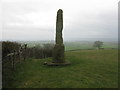
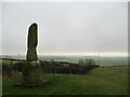
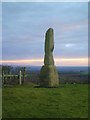
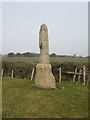
Dating from the 9th century, the Pastscape record D37472 says this is "a rough cut rectangular sandstone base, badly worn, but is said to have featured interlacing ornament. This is probably a Legs Cross which marked the subdivision of a major Anglo Saxon estate centred on Gainford Village."
Locally it is said to have once had the inscription 'LEG' carved into it, from reused Roman masonry (the Roman fort and bridge at Piercebridge is nearby), hence the name, although, as confirmed by the Pastscape record above, 'legge' is also the Anglo-Saxon word for 'boundary'.
The cross lies just to the west of the B6275, largely hidden behind a hedge, just below the brow of a hill. There is a small car park immediately to the north, at the crossroads of the B6275 with roads to Bolam to the west and Houghton Bank to the east. A footpath with stile leading to Brownhouse Lane is at the southern end of the car park, although in summer can be hidden by tall weeds. Once at the footpath sign, the cross is clearly visible against the hedge line 40 metres to the south.
At first glance the cross appears to be three large lumps of modern concrete which form an obelisk, similar to the shaft of an old preaching cross, but on closer inspection it is made of sandstone and very old and worn. This grade II listed structure also appears to sit at the eastern edge of a circular mound which stands out against the large, flat field.
You may be viewing yesterday's version of this page. To see the most up to date information please register for a free account.
")
")
")
Do not use the above information on other web sites or publications without permission of the contributor.
Nearby Images from Geograph Britain and Ireland:

©2017(licence)
©2017(licence)
©2022(licence)
©2014(licence)
©2019(licence)
The above images may not be of the site on this page, they are loaded from Geograph.
Please Submit an Image of this site or go out and take one for us!
Click here to see more info for this site
Nearby sites
Key: Red: member's photo, Blue: 3rd party photo, Yellow: other image, Green: no photo - please go there and take one, Grey: site destroyed
Download sites to:
KML (Google Earth)
GPX (GPS waypoints)
CSV (Garmin/Navman)
CSV (Excel)
To unlock full downloads you need to sign up as a Contributory Member. Otherwise downloads are limited to 50 sites.
Turn off the page maps and other distractions
Nearby sites listing. In the following links * = Image available
2.4km ENE 70° Shackleton Beacon* Hillfort (NZ22952331)
5.8km NE 37° Eldon Hill Stone Circle* Stone Circle (NZ2416627139)
6.1km N 10° Auckland St Andrew Ancient Cross* Ancient Cross (NZ21752846)
6.1km NNE 24° Eldon Fort* Hillfort (NZ23202804)
6.4km NNW 337° Eldon (Durham)* Rock Art (NZ1816528358)
6.6km S 170° Smotherlaw Barrow* Round Barrow(s) (NZ21881601)
6.6km SSW 213° Gainford Stone* Rock Art (NZ1708016920)
6.9km SW 222° Gainford Spa* Holy Well or Sacred Spring (NZ16131738)
6.9km SSW 214° St. Mary's Well (Gainford)* Holy Well or Sacred Spring (NZ169167)
7.2km S 178° Betty Watson's Hill* Round Barrow(s) (NZ21041526)
7.3km S 179° Howe Hill (Piercebridge)* Round Barrow(s) (NZ20881515)
7.5km SSE 166° St Edwin's (High Coniscliffe)* Ancient Cross (NZ2257815234)
7.6km E 93° St Andrew's Church (Aycliffe)* Ancient Cross (NZ2830622162)
7.8km WSW 257° St Mary The Virgin, Staindrop* Ancient Cross (NZ13082064)
7.8km NNW 347° Escomb Cross* Ancient Cross (NZ1892830139)
7.9km SW 232° Winston Station Rock Art (NZ1445017650)
8.4km N 11° Coundon Burn Barrow Long Barrow (NZ223307)
8.8km SW 227° Winston Shap Erratic* Natural Stone / Erratic / Other Natural Feature (NZ14251645)
9.6km WSW 247° Cleatlam Wayside Cross* Ancient Cross (NZ1189318683)
10.3km NNW 327° Lively Well (Witton-le-Wear)* Holy Well or Sacred Spring (NZ1505931172)
10.4km SSW 197° St Cuthbert (Forcett)* Ancient Cross (NZ177125)
10.6km SSW 196° Stanwick Hillfort* Hillfort (NZ17831229)
10.7km S 191° Kirkbridge Farmhouse Barrow* Round Barrow(s) (NZ187120)
10.7km SSW 192° Stanwick Crosses* Ancient Cross (NZ18511198)
11.2km SE 133° The Bulmer Stone* Natural Stone / Erratic / Other Natural Feature (NZ29021496)
View more nearby sites and additional images


 We would like to know more about this location. Please feel free to add a brief description and any relevant information in your own language.
 Wir möchten mehr über diese Stätte erfahren. Bitte zögern Sie nicht, eine kurze Beschreibung und relevante Informationen in Deutsch hinzuzufügen.
 Nous aimerions en savoir encore un peu sur les lieux. S'il vous plaît n'hesitez pas à ajouter une courte description et tous les renseignements pertinents dans votre propre langue.
 Quisieramos informarnos un poco más de las lugares. No dude en añadir una breve descripción y otros datos relevantes en su propio idioma.