<< Our Photo Pages >> Icomb Camp - Hillfort in England in Gloucestershire
Submitted by 4clydesdale7 on Thursday, 25 March 2004 Page Views: 8775
Iron Age and Later PrehistorySite Name: Icomb CampCountry: England
NOTE: This site is 3.573 km away from the location you searched for.
County: Gloucestershire Type: Hillfort
Nearest Town: Chipping Norton Nearest Village: Icomb
Map Ref: SP20352315 Landranger Map Number: 163
Latitude: 51.906520N Longitude: 1.705602W
Condition:
| 5 | Perfect |
| 4 | Almost Perfect |
| 3 | Reasonable but with some damage |
| 2 | Ruined but still recognisable as an ancient site |
| 1 | Pretty much destroyed, possibly visible as crop marks |
| 0 | No data. |
| -1 | Completely destroyed |
| 5 | Superb |
| 4 | Good |
| 3 | Ordinary |
| 2 | Not Good |
| 1 | Awful |
| 0 | No data. |
| 5 | Can be driven to, probably with disabled access |
| 4 | Short walk on a footpath |
| 3 | Requiring a bit more of a walk |
| 2 | A long walk |
| 1 | In the middle of nowhere, a nightmare to find |
| 0 | No data. |
| 5 | co-ordinates taken by GPS or official recorded co-ordinates |
| 4 | co-ordinates scaled from a detailed map |
| 3 | co-ordinates scaled from a bad map |
| 2 | co-ordinates of the nearest village |
| 1 | co-ordinates of the nearest town |
| 0 | no data |
Internal Links:
External Links:
I have visited· I would like to visit
4clydesdale7 visited on 8th Apr 2012 - their rating: Cond: 1 Amb: 4 Access: 5 Superb views - earthworks difficult to make out - lots of interesting sites in the area
")
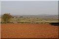
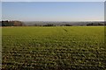
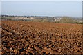
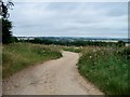
This elongated oval enclosure sits at the highest point of Icomb Hill about 2 miles SE of Stow on the Wold and Maugersbury. Its existence was first mentioned in TR Nash's History of Worcestershire Vol 2 p 2 and Britton and Brayley's Beauties of England 1803 Vol 5 p 646 but the reputable G Witts in his epic Archaeological Handbook of the County of Gloucester 1883 (Camp 55) started expressions of doubt by stating 'the earthworks are so slight that some doubt has been expressed as to the existence of any fortified position here' and later 'but the bank has been partly destroyed by the effects of cultivation'. EH on its pastscape website Gloucestershire: Cotswold: Icomb: Monument 332646 can only confirm its existence from cropmarks but then the Ordnance Survey has always shown earthworks here.
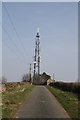
Strategically its position makes good sense (and there is a TV/telephone relay station just NW of the hill's trig point) commanding the Fosseway just about 500m to the West and the Evenlode Valley to the East with a superb panorama to the SSE towards Burford and NNW to Stow on the Wold. There is very sparse evidence of any earthworks because of farming operations over hundreds of years.
The camp is worth a visit just for the views alone - then you appreciate that there would have been nowhere more suitable locally for a Camp.
You may be viewing yesterday's version of this page. To see the most up to date information please register for a free account.
")
")
Do not use the above information on other web sites or publications without permission of the contributor.
Nearby Images from Geograph Britain and Ireland:
©2014(licence)
©2014(licence)
©2014(licence)
©2009(licence)
©2010(licence)
The above images may not be of the site on this page, they are loaded from Geograph.
Please Submit an Image of this site or go out and take one for us!
Click here to see more info for this site
Nearby sites
Key: Red: member's photo, Blue: 3rd party photo, Yellow: other image, Green: no photo - please go there and take one, Grey: site destroyed
Download sites to:
KML (Google Earth)
GPX (GPS waypoints)
CSV (Garmin/Navman)
CSV (Excel)
To unlock full downloads you need to sign up as a Contributory Member. Otherwise downloads are limited to 50 sites.
Turn off the page maps and other distractions
Nearby sites listing. In the following links * = Image available
1.8km NW 318° St Edwards well* Holy Well or Sacred Spring (SP191245)
2.4km S 184° Wyck Beacon bowl barrow* Round Barrow(s) (SP20182078)
2.9km NNW 342° Stow Camp* Hillfort (SP19442595)
3.1km NNW 340° St Edwards (Stow Well) Well* Holy Well or Sacred Spring (SP1931126039)
3.7km SW 231° Salmonsbury Camp* Hillfort (SP175208)
3.7km NW 315° Our Lady's Well (near Stow)* Holy Well or Sacred Spring (SP177258)
3.8km WNW 298° The Horestone (Lower Swell)* Standing Stone (Menhir) (SP170249)
3.8km NW 310° Whittlestone* Standing Stone (Menhir) (SP174256)
4.0km NNW 342° Broadwell Chambered Tomb (SP191270)
4.2km NW 309° Lower Swell barrow* Chambered Tomb (SP17032580)
4.4km SE 145° Idbury Camp* Hillfort (SP22871954)
4.6km SSE 162° Fifield Chambered Cairn (SP218188)
4.6km NW 317° Poles Wood East* Long Barrow (SP172265)
4.6km NW 307° The Tump* Round Barrow(s) (SP166259)
4.8km NW 316° Pole's Wood West* Chambered Tomb (SP170266)
4.8km NW 312° Poles Wood South* Long Barrow (SP16732636)
5.1km WNW 298° Condicote Lane Chambered Tomb (SP158255)
6.5km NNW 333° Ganborough* Chambered Tomb (SP174289)
6.5km WSW 248° Cold Aston* Chambered Tomb (SP14342065)
6.5km WNW 293° New Close Chambered Tomb (SP143257)
6.6km WNW 294° Eyeford Chambered Cairn (SP143258)
7.0km WNW 298° Swell Wold round barrow* Round Barrow(s) (SP14132648)
7.1km NE 45° Adlestrop Hill (round) Round Barrow(s) (SP253282)
7.2km NE 45° Adlestrop Hill* Long Barrow (SP25362827)
7.2km NW 317° Condicote henge* Henge (SP15392837)
View more nearby sites and additional images


 We would like to know more about this location. Please feel free to add a brief description and any relevant information in your own language.
 Wir möchten mehr über diese Stätte erfahren. Bitte zögern Sie nicht, eine kurze Beschreibung und relevante Informationen in Deutsch hinzuzufügen.
 Nous aimerions en savoir encore un peu sur les lieux. S'il vous plaît n'hesitez pas à ajouter une courte description et tous les renseignements pertinents dans votre propre langue.
 Quisieramos informarnos un poco más de las lugares. No dude en añadir una breve descripción y otros datos relevantes en su propio idioma.