

<< Our Photo Pages >> Stoke Flat - Stone Circle in England in Derbyshire
Submitted by Vicky on Wednesday, 18 September 2002 Page Views: 23884
Neolithic and Bronze AgeSite Name: Stoke Flat Alternative Name: Froggatt EdgeCountry: England County: Derbyshire Type: Stone Circle
Nearest Town: Hathersage Nearest Village: Grindleford
Map Ref: SK24967679 Landranger Map Number: 119
Latitude: 53.287495N Longitude: 1.627054W
Condition:
| 5 | Perfect |
| 4 | Almost Perfect |
| 3 | Reasonable but with some damage |
| 2 | Ruined but still recognisable as an ancient site |
| 1 | Pretty much destroyed, possibly visible as crop marks |
| 0 | No data. |
| -1 | Completely destroyed |
| 5 | Superb |
| 4 | Good |
| 3 | Ordinary |
| 2 | Not Good |
| 1 | Awful |
| 0 | No data. |
| 5 | Can be driven to, probably with disabled access |
| 4 | Short walk on a footpath |
| 3 | Requiring a bit more of a walk |
| 2 | A long walk |
| 1 | In the middle of nowhere, a nightmare to find |
| 0 | No data. |
| 5 | co-ordinates taken by GPS or official recorded co-ordinates |
| 4 | co-ordinates scaled from a detailed map |
| 3 | co-ordinates scaled from a bad map |
| 2 | co-ordinates of the nearest village |
| 1 | co-ordinates of the nearest town |
| 0 | no data |
Internal Links:
External Links:
I have visited· I would like to visit
elad13 ermine would like to visit
Marko visited on 28th Jan 2022 - their rating: Cond: 2 Amb: 3 Access: 4
Pressure visited on 2nd May 2021 - their rating: Cond: 4 Amb: 5 Access: 4
stretchyboy visited on 13th Jul 2020 - their rating: Cond: 3 Amb: 4 Access: 4
BolshieBoris visited on 1st Jan 1983 - their rating: Cond: 4 Amb: 4 Access: 4
rldixon MartinRS have visited here
Average ratings for this site from all visit loggers: Condition: 3.25 Ambience: 4 Access: 4
")
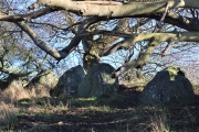
It consists of an embanked stone circle with two entrances exactly opposite, to the north-north-west and south-south-east. Traces of dry-stone walling in the northern entrance suggest that it may have been deliberately blocked at some time in prehistory. The bank is approximately 2m wide, 11.5m internally and 15.5m externally in diameter.
Both entrances are lined with a set of parallel stones, with four remaining in the southern entrance and three in the northern one. Elsewhere four smaller stones are set at the inner edge of the bank. It is clear that there are quite a few missing and may have been as many as sixteen originally. The majority of the stones are of typical Derbyshire height, about 0.5m tall, while the largest stone, flanking one of the entrances, is over 1m in height.
You may be viewing yesterday's version of this page. To see the most up to date information please register for a free account.
")
")
")
")
")
")
")
")
")
")
")
")
")
")
")
")
")
")
")
")
")
")
")
")
These are just the first 25 photos of Stoke Flat. If you log in with a free user account you will be able to see our entire collection.
Do not use the above information on other web sites or publications without permission of the contributor.
Click here to see more info for this site
Nearby sites
Key: Red: member's photo, Blue: 3rd party photo, Yellow: other image, Green: no photo - please go there and take one, Grey: site destroyed
Download sites to:
KML (Google Earth)
GPX (GPS waypoints)
CSV (Garmin/Navman)
CSV (Excel)
To unlock full downloads you need to sign up as a Contributory Member. Otherwise downloads are limited to 50 sites.
![]()
![]()
![]()
Turn off the page maps and other distractions
Nearby sites listing. In the following links * = Image available
2.0km ENE 66° White Edge Cairn* Cairn (SK26847762)
2.1km SW 236° Stoney Middleton Thermal Springs* Holy Well or Sacred Spring (SK232756)
2.1km W 259° Riley Graves* Standing Stone (Menhir) (SK22867639)
2.1km ENE 65° The Hurkling Stone* Marker Stone (SK269777)
2.4km W 271° Top Of Riley Stone Circle (SK226768)
2.6km WSW 247° Eyam Boundary Stone* Marker Stone (SK226758)
2.6km SE 128° Barbrook 5* Ring Cairn (SK270752)
2.7km NW 319° Eyam Moor III* Stone Circle (SK232788)
2.8km W 279° Mompesson's Well* Holy Well or Sacred Spring (SK222772)
2.8km ESE 111° Big Moor Cairns SW* Barrow Cemetery (SK27587579)
2.8km NW 322° Eyam Moor II* Stone Circle (SK232790)
2.9km SE 129° Swine Sty* Ancient Village or Settlement (SK272750)
2.9km ESE 119° Big Moor* Ancient Village or Settlement (SK275754)
2.9km ESE 114° Barbrook Cupmarked Stone* Standing Stone (Menhir) (SK27647560)
2.9km ESE 110° Barbrook 2* Stone Circle (SK27757582)
3.0km N 7° Lawrence Field* Stone Circle (SK253798)
3.0km ESE 111° Big Moor Cairn Field* Barrow Cemetery (SK278757)
3.1km NNE 32° Little John's Well (Hathersage)* Holy Well or Sacred Spring (SK266794)
3.1km ESE 113° Barbrook 1* Stone Circle (SK27857558)
3.2km ESE 112° Barbrook cairn* Cairn (SK27917561)
3.2km W 263° St Lawrence (Eyam)* Ancient Cross (SK218764)
3.3km NW 313° Wet Withens* Stone Circle (SK22557900)
3.3km NW 313° Eyam Moor Barrow* Long Barrow (SK22547900)
3.4km W 269° Eyam Museum* Museum (SK2159176729)
3.4km E 82° Barbrook 3* Stone Circle (SK28337728)
View more nearby sites and additional images


 We would like to know more about this location. Please feel free to add a brief description and any relevant information in your own language.
 Wir möchten mehr über diese Stätte erfahren. Bitte zögern Sie nicht, eine kurze Beschreibung und relevante Informationen in Deutsch hinzuzufügen.
 Nous aimerions en savoir encore un peu sur les lieux. S'il vous plaît n'hesitez pas à ajouter une courte description et tous les renseignements pertinents dans votre propre langue.
 Quisieramos informarnos un poco más de las lugares. No dude en añadir una breve descripción y otros datos relevantes en su propio idioma.