<< Our Photo Pages >> Fair Rosamund's Well - Holy Well or Sacred Spring in England in Oxfordshire
Submitted by vicky on Tuesday, 20 July 2004 Page Views: 7969
Springs and Holy WellsSite Name: Fair Rosamund's Well Alternative Name: Everswell (Woodstock)Country: England County: Oxfordshire Type: Holy Well or Sacred Spring
Nearest Town: Long Harborough Nearest Village: Blenheim
Map Ref: SP43651646 Landranger Map Number: 164
Latitude: 51.845041N Longitude: 1.367777W
Condition:
| 5 | Perfect |
| 4 | Almost Perfect |
| 3 | Reasonable but with some damage |
| 2 | Ruined but still recognisable as an ancient site |
| 1 | Pretty much destroyed, possibly visible as crop marks |
| 0 | No data. |
| -1 | Completely destroyed |
| 5 | Superb |
| 4 | Good |
| 3 | Ordinary |
| 2 | Not Good |
| 1 | Awful |
| 0 | No data. |
| 5 | Can be driven to, probably with disabled access |
| 4 | Short walk on a footpath |
| 3 | Requiring a bit more of a walk |
| 2 | A long walk |
| 1 | In the middle of nowhere, a nightmare to find |
| 0 | No data. |
| 5 | co-ordinates taken by GPS or official recorded co-ordinates |
| 4 | co-ordinates scaled from a detailed map |
| 3 | co-ordinates scaled from a bad map |
| 2 | co-ordinates of the nearest village |
| 1 | co-ordinates of the nearest town |
| 0 | no data |
Be the first person to rate this site - see the 'Contribute!' box in the right hand menu.
Internal Links:
External Links:
")
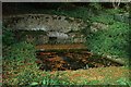
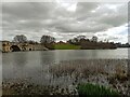
Recorded as Pastscape Monument 336661, we learn this well was first documented in 1165-66 as a spring "running through a complex of pools, surrounded by claustral (relating to cloister or religious house) courts".
The Journal of Antiquities also includes an entry for Rosamond’s Well, Blenheim Park, Woodstock, Oxfordshire, which includes a photograph of the well and Godstow Abbey, where Rosamund de Clifford (after whom the well was named) was buried. The Journal adds: "But back in the 12th century the well was called Everswell, maybe because it was ‘never ever’ known to run dry, even in the driest spells of weather; and in the past the water had some curative properties as pilgrims were wont to come here and partake of it in bottles – in those distant times, but in fact the well has only been named after Rosamond since the 16th century". The JoA also gives a list of reference sources for more information.
You may be viewing yesterday's version of this page. To see the most up to date information please register for a free account.
")
Do not use the above information on other web sites or publications without permission of the contributor.
Nearby Images from Geograph Britain and Ireland:
©2008(licence)
©2008(licence)
©2018(licence)
©2016(licence)
©2023(licence)
The above images may not be of the site on this page, they are loaded from Geograph.
Please Submit an Image of this site or go out and take one for us!
Click here to see more info for this site
Nearby sites
Key: Red: member's photo, Blue: 3rd party photo, Yellow: other image, Green: no photo - please go there and take one, Grey: site destroyed
Download sites to:
KML (Google Earth)
GPX (GPS waypoints)
CSV (Garmin/Navman)
CSV (Excel)
To unlock full downloads you need to sign up as a Contributory Member. Otherwise downloads are limited to 50 sites.
Turn off the page maps and other distractions
Nearby sites listing. In the following links * = Image available
2.1km NNW 333° Blenheim Great Park Ancient Village or Settlement (SP427183)
3.5km NNW 338° Glympton Farm Ancient Village or Settlement (SP423197)
4.1km WSW 257° North Leigh Roman Villa* Ancient Village or Settlement (SP39661547)
4.9km NNW 332° Out Wood & Berrings Wood Ancient Village or Settlement (SP413208)
5.4km NNW 336° Grimsdyke Farm Ancient Village or Settlement (SP41402141)
5.6km SE 144° Yarnton* Ancient Village or Settlement (SP4712)
6.1km NW 326° Home Farm Ancient Village or Settlement (SP402215)
6.4km WSW 256° The Lady's Well (Oxfordshire)* Holy Well or Sacred Spring (SP374148)
6.7km SW 221° Eynsham Park Camp Hillfort (SP393114)
6.9km NW 310° Model Farm Ancient Village or Settlement (SP383209)
7.9km WNW 289° Sturt Henge* Modern Stone Circle etc (SP36111899)
7.9km NNE 16° Hoar Stone at Barton* Long Barrow (SP458241)
7.9km S 189° Eynsham Timber Circle Timber Circle (SP425086)
8.5km S 188° Deadman's Burial 2 Henge (SP42610807)
8.6km S 189° Deadman's Burial 1 Misc. Earthwork (SP42350795)
8.6km WNW 286° Cornbury Park Round Barrow(s) (SP35311878)
9.3km NW 322° Hoar Stone at Enstone* Chambered Tomb (SP37792375)
9.4km NW 306° Thorsbrook Spring* Holy Well or Sacred Spring (SP360219)
9.5km NW 307° Thor Stone* Standing Stone (Menhir) (SP35932208)
9.8km SSE 150° St Margaret's Well (Binsey)* Holy Well or Sacred Spring (SP486080)
10.5km W 273° Churchill Copse* Long Barrow (SP33161685)
10.7km W 271° Slatepits Copse* Chambered Tomb (SP329165)
11.0km S 191° Stanton Harcourt Church Cross* Ancient Cross (SP4164305666)
11.2km WSW 243° Churchill Plain Chambered Tomb (SP33711129)
11.4km SE 144° Walton Well* Holy Well or Sacred Spring (SP5047907312)
View more nearby sites and additional images


 We would like to know more about this location. Please feel free to add a brief description and any relevant information in your own language.
 Wir möchten mehr über diese Stätte erfahren. Bitte zögern Sie nicht, eine kurze Beschreibung und relevante Informationen in Deutsch hinzuzufügen.
 Nous aimerions en savoir encore un peu sur les lieux. S'il vous plaît n'hesitez pas à ajouter une courte description et tous les renseignements pertinents dans votre propre langue.
 Quisieramos informarnos un poco más de las lugares. No dude en añadir una breve descripción y otros datos relevantes en su propio idioma.