<< Our Photo Pages >> St Catherine's Hill (Hampshire) - Hillfort in England in Hampshire

Submitted by Jimit on Tuesday, 24 February 2004  Page Views: 57453

Iron Age and Later PrehistorySite Name: St Catherine's Hill (Hampshire)
Country: England County: Hampshire Type: Hillfort
Nearest Town: Winchester
Map Ref: SU48422766  Landranger Map Number: 185
Latitude: 51.046258N  Longitude: 1.310663W
Condition:
5Perfect
4Almost Perfect
3Reasonable but with some damage
2Ruined but still recognisable as an ancient site
1Pretty much destroyed, possibly visible as crop marks
0No data.
-1Completely destroyed
3 Ambience:
5Superb
4Good
3Ordinary
2Not Good
1Awful
0No data.
3 Access:
5Can be driven to, probably with disabled access
4Short walk on a footpath
3Requiring a bit more of a walk
2A long walk
1In the middle of nowhere, a nightmare to find
0No data.
4 Accuracy:
5co-ordinates taken by GPS or official recorded co-ordinates
4co-ordinates scaled from a detailed map
3co-ordinates scaled from a bad map
2co-ordinates of the nearest village
1co-ordinates of the nearest town
0no data
4

Internal Links:
External Links:

I have visited· I would like to visit

Couplands saw from a distance on 15th Sep 2023 - their rating: Cond: 2 Amb: 3 Access: 3

SolarMegalith visited on 24th Jun 2017 - their rating: Cond: 3 Amb: 4 Access: 4

Rulebritannia visited on 1st Apr 2013 - their rating: Cond: 2 Amb: 3 Access: 3

JimChampion have visited here

Average ratings for this site from all visit loggers: Condition: 2.33 Ambience: 3.33 Access: 3.33
St Catherine's Hill (Hampshire)
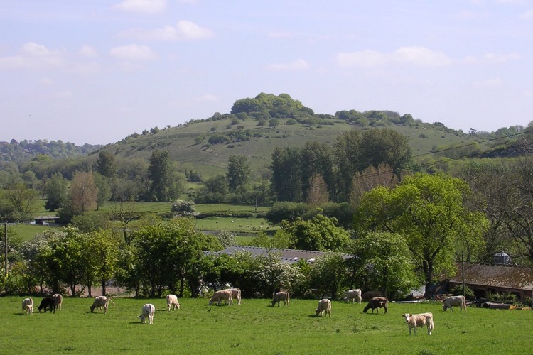
St Catherine's Hill (Hampshire) submitted by JimChampion : May 2005. Looking NE at the hillfort from across the Itchen valley. A familiar aspect to those who travel north up the M3 from Southampton (just before the controversial Twyford Down cutting). Only one of the cows in the foreground has noticed me standing precariously on a gatepost to take this picture. (Vote or comment on this photo)
Hillfort in Hampshire.

The defences of this early Iron Age hillfort consist of two banks with a ditch inbetween, and an original entrance to the northeast. There is evidence that the defences were periodically improved as times of war and peace came and went. The hillfort was left deserted after it was sacked in the first century BC.

The Miz Maze lies within the hillfort, close to the original entrance through the ramparts. St. Catherines Chapel stood in the middle of the clump of beech trees on the summit (no remains).

The whole area is a managed Nature Reserve and has beautiful views to the east over the Itchen flood plain, Winchester and St. Cross.

Access There are several ways to approach the hillfort.

1. The Tun Bridge parking area on the small road going west just after going under the disused railway. [From junction 10 of the M3, follow the brown sign for 'St Catherine's Hill' viewpoint]. A steep path with steps leads back under the railway and leads to the north-west entrance to the hillfort, where the Miz Maze is.

2, Take the Morestead Road to Morestead (south off the A31 next to junction 10 of the M3), where the road turns sharply SE, there is a small lay-by. Walk over the footbridge and into the nature reserve. As you descend into the 'Plague Pits Valley' the hill is on your right.

3, Coming south on the M3, take Marwell Zoo sign at junction 11, turn right (under M3) and then left. Park near the viaduct and follow the blue footpath signs. The path back to the hill diverges, to the left is a delightful walk by the Itchen Navigation Canal (one of the earliest) which will lead you back to 1. Divert to the right by the waterfall to climb Plague Pits Valley and the hill.

From parking place 2 if you keep to the left (east) the Dongas are a series of deeply cut tracks made by Prehistoric and Mediaeval travellers going to the site of the Itchen ford - now Winchester.

Further on, overlooking the M3 is a standing stone about 2 metres high. It is inscribed with the names of the b******s who allowed this rape of Twyford Down and was erected as an indictment and a memorial.
You may be viewing yesterday's version of this page. To see the most up to date information please register for a free account.


St Catherine's Hill (Hampshire)
St Catherine's Hill (Hampshire) submitted by JimChampion : St Catherine's Hill from the watermeadows of the Itchen Valley, near St Cross. (1 comment - Vote or comment on this photo)

St Catherine's Hill (Hampshire)
St Catherine's Hill (Hampshire) submitted by JimChampion : January 2005. Composite image of the SE side of St Catherine's Hill, viewed from the top of the Twyford Down motorway cutting. Nice view, shame about the noise. (Vote or comment on this photo)

St Catherine's Hill (Hampshire)
St Catherine's Hill (Hampshire) submitted by JimChampion : Earthworks on the eastern side of the hillfort, looking south from the path along the ditch. Inner bank is on the right (planted with beeches), counterscarp bank on the left. (Vote or comment on this photo)

St Catherine's Hill (Hampshire)
St Catherine's Hill (Hampshire) submitted by JimChampion : Composite photo of St Catherines Hill from high on Twyford Down to the south (next to the motorway cutting). The rampart around the top of the hill is clearly defined by the evening sunshine. The Itchen valley is to the left of the hill. (2 comments - Vote or comment on this photo)

St Catherine's Hill (Hampshire)
St Catherine's Hill (Hampshire) submitted by JimChampion : Looking west from the southern edge of the hillfort, with frost on the ground and mist lurking in the Itchen valley below. The shadows from the low sun clearly show up the ditch between the inner and outer ramparts.

St Catherine's Hill (Hampshire)
St Catherine's Hill (Hampshire) submitted by JimChampion : A view of the hillfort's defences on the northeastern side of the hill. On the left, the bank, in the middle the ditch (where the modern path runs up from the Tun Bridge car park) and on the right the counterscarp bank.

St Catherine's Hill (Hampshire)
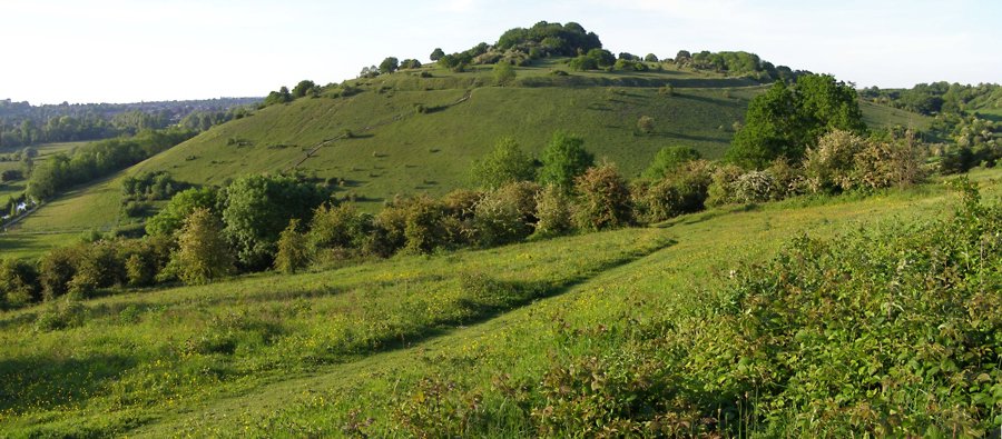
St Catherine's Hill (Hampshire) submitted by SolarMegalith : St Catherine's Hill seen from the south with earthworks of the hillfort clearly distinguishable (photo taken on June 2017).

St Catherine's Hill (Hampshire)
St Catherine's Hill (Hampshire) submitted by SolarMegalith : St Catherine's Hill - rampart and ditch in the eastern part of the hillfort (photo taken on June 2017).

St Catherine's Hill (Hampshire)
St Catherine's Hill (Hampshire) submitted by SolarMegalith : View from the rampart to the ditch and couterscarp bank i nthe northern part of St Catherine's Hill Iron Age hillfort (photo taken on June 2017).

St Catherine's Hill (Hampshire)
St Catherine's Hill (Hampshire) submitted by SolarMegalith : View from the rampart to the SE with visible ditch and counterscarp bank (photo taken on July 2017).

St Catherine's Hill (Hampshire)
St Catherine's Hill (Hampshire) submitted by SolarMegalith : St Catherine's Hill - rampart and ditch in the southern part of the hillfort (photo taken on June 2017).

St Catherine's Hill (Hampshire)
St Catherine's Hill (Hampshire) submitted by SolarMegalith : View along the top of a rampart in the southern part of St Catherine's Hill hillfort (photo taken on June 2017).

St Catherine's Hill (Hampshire)
St Catherine's Hill (Hampshire) submitted by SolarMegalith : An Iron Age hillfort on St Catherine's Hill seen from Magdalen Hill Down barrow cemetery (photo taken on November 2011).

St Catherine's Hill (Hampshire)
St Catherine's Hill (Hampshire) submitted by JimChampion : August 2007. The inner rampart of the hillfort, looking south with the Itchen valley to the right. The orange light is from the setting sun.

St Catherine's Hill (Hampshire)
St Catherine's Hill (Hampshire) submitted by JimChampion : August 2007. Climbing the wooden staircase to the top of the hill, racing the setting sun. This is the 'easy' way up, from the footpath along the Itchen Navigation.

St Catherine's Hill (Hampshire)
St Catherine's Hill (Hampshire) submitted by JimChampion : Looking up at St Catherine's Hill from Garnier Road. The Itchen water meadows are in the foreground. In the trees at the foot of the hill are the remains of three past methods of transport - a disused road, a disused railway line and a disused navigation (canal).

St Catherine's Hill (Hampshire)
St Catherine's Hill (Hampshire) submitted by JimChampion : Looking up at the western side of St Catherine's Hill from the Itchen water meadows, near St Cross.

St Catherine's Hill (Hampshire)
St Catherine's Hill (Hampshire) submitted by JimChampion : A view east towards St Catherine's Hill from Whiteshute Ridge. The west side of the hill is illuminated by fleeting sunlight, in the foreground the St Cross suburb of Winchester is in the shadow of a cloud. The modest ditch and rampart around the bowl-shaped hill are clearly visible, even from this distance.

St Catherine's Hill (Hampshire)
St Catherine's Hill (Hampshire) submitted by JimChampion : May 2005. Over 300 steps up to the hillfort's ramparts! Park at the Tun Bridge car park on the north side of the hill, walk along the path beside the Itchen navigation canal and turn left to find the start of these steps on the south side of the hill.

St Catherine's Hill (Hampshire)
St Catherine's Hill (Hampshire) submitted by JimChampion : May 2005. Looking north at the hillfort from the path alongside the Itchen navigation canal. It looks like an upturned bowl from this angle. (1 comment)

St Catherine's Hill (Hampshire)
St Catherine's Hill (Hampshire) submitted by JimChampion : May 2005. A view of the inner rampart on the southern side of the hillfort. At many hillforts there is a chalky path along the rampart, worn by the feet of visitors: why is it that there is often also this undulation of the rampart? Is it anything to do with the way they were constructed (and subsequently weathered and eroded)?

St Catherine's Hill (Hampshire)
St Catherine's Hill (Hampshire) submitted by JimChampion : January 2005, winter morning sky and the beech trees on the highest point of the hillfort.

St Catherine's Hill (Hampshire)
St Catherine's Hill (Hampshire) submitted by DavidCWoods : I'm ready to admit that I'm not as fit as I might be, but this was steep! The mounds and ditch were inside the tree line.

St Catherine's Hill (Hampshire)
St Catherine's Hill (Hampshire) submitted by DavidCWoods : View of the double mound with the ditch between. If these were defensive earthworks I would think that they were pretty effective !

These are just the first 25 photos of St Catherine's Hill (Hampshire). If you log in with a free user account you will be able to see our entire collection.

Do not use the above information on other web sites or publications without permission of the contributor.
Click here to see more info for this site

Nearby sites

Click here to view sites on an interactive OS map

Key: Red: member's photo, Blue: 3rd party photo, Yellow: other image, Green: no photo - please go there and take one, Grey: site destroyed

Download sites to:
KML (Google Earth)
GPX (GPS waypoints)
CSV (Garmin/Navman)
CSV (Excel)

To unlock full downloads you need to sign up as a Contributory Member. Otherwise downloads are limited to 50 sites.


Turn off the page maps and other distractions

Nearby sites listing. In the following links * = Image available
 67m ENE 64° Mizmaze* Turf Maze (SU48482769)
 546m E 100° Twyford Down monument* Modern Stone Circle etc (SU48962757)
 681m E 96° The Dongas* Ancient Trackway (SU491276)
 1.6km N 352° Winchester Cathedral Wells* Holy Well or Sacred Spring (SU482292)
 1.8km N 350° Winchester City Museum* Museum (SU4809729407)
 2.0km WSW 238° Compton Down Barrows* Round Barrow(s) (SU46762660)
 2.0km NNW 339° Hampshire Jubilee Sculpture* Modern Stone Circle etc (SU477295)
 2.2km NNW 336° Oram's Arbour Hillfort (SU475297)
 2.3km NE 44° Magdalen Hill Down* Barrow Cemetery (SU49992933)
 2.7km S 187° Twyford stone circle* Stone Circle (SU481250)
 2.9km WSW 257° Texas Barrows* Round Barrow(s) (SU4558926993)
 3.7km E 84° Telegraph Hill Bowl Barrow* Round Barrow(s) (SU521281)
 4.1km E 89° Cheesefoot Head Barrows* Barrow Cemetery (SU52572777)
 4.2km SE 125° Morestead Warren* Long Barrow (SU519253)
 5.0km NNW 330° Flowerdown Barrows* Barrow Cemetery (SU459320)
 5.9km SE 124° Longwood Barrow Long Barrow (SU534244)
 6.2km WNW 288° West Wood Bowl Barrow* Round Barrow(s) (SU42522949)
 6.4km W 259° Merdon Castle* Hillfort (SU421264)
 7.3km WNW 283° Robin Hood's Barrow (Winchester)* Round Barrow(s) (SU41322927)
 8.2km W 280° Farley Mount* Round Barrow(s) (SU403290)
 8.5km N 353° South Wonston* Barrow Cemetery (SU4723736091)
 9.0km W 280° Withering Corner Barrow Cemetery (SU395291)
 9.8km NE 47° Itchen Stoke Down Barrows Round Barrow(s) (SU5554334384)
 10.2km NNE 29° Micheldever Wood Banjo Enclosure* Ancient Village or Settlement (SU53353658)
 10.3km NNE 28° Micheldever Wood Bell Barrow* Round Barrow(s) (SU53213678)
View more nearby sites and additional images

<< Gun Rith

Camp Barrow >>

Please add your thoughts on this site

The Singing Neanderthals: The Origins of Music, Language, Mind and Body

The Singing Neanderthals: The Origins of Music, Language, Mind and Body

Sponsors

Auto-Translation (Google)

Translate from English into:

"St Catherine's Hill (Hampshire)" | Login/Create an Account | 4 News and Comments
  
Go back to top of page    Comments are owned by the poster. We aren't responsible for their content.
Re: St Catherine's Hill (Hampshire) by Anonymous on Monday, 01 April 2013
Walked here today its a lovely site, cows are currently feeding on the top.
[ Reply to This ]

Re: St Catherine's Hill (Hampshire) by Anonymous on Sunday, 02 September 2007
Ummm, Can you please give direction to this place FROM somwhere that can be found on a map. Go west? Hey? from which starting point?.

Take the roman road to morestead - once again, FROM WHERE?!!!


how about road names, designartion, etc.

Thank you (in frustration)
[ Reply to This ]
    Re: directions to St Catherine's Hill (Hampshire) by JimChampion on Sunday, 02 September 2007
    (User Info | Send a Message)
    Example...

    Head north on the M3 motorway from Southampton (its on most maps).
    Leave motorway at Junction 10.
    There's a roundabout at the bottom of the slip road - take the first exit (it's called Bull Drove).
    The Bull Drove road narrows as it passes through an arch beneath a disused railway line. Immediately after this arch, on the left, is a car park with one of those height-restriction barriers. This is Tun Bridge car park, right next to St Catherine's Hill. No charge.

    Unfortunately there's no way of coming off the M3 southbound at Junction 10 - its probably easiest to go on to Junction 11 where you can leave the motorway, then join the northbound M3 and proceed as described above.
    [ Reply to This ]

Re: St Catherine's Hill (Hampshire) by Anonymous on Sunday, 27 November 2005
To Jim Champion, Dave Woods and Jimit: Fifty years ago (mid-November 1955) almost to this very day, I did a sketch at St. Catherine's Hill. Subsequently executed a painting back here in New England (CT). Yesterday I had the urge to look at some old works in storage and found the unfinished one of St. C. Over the years I had forgotten the hill's location (thought Somerset) and on a hunch I went on line this am and there was Jim C's cow staring at me from the very location of my sketch. The wonders of hi-tech. Thank ypu all for your interest in the Hill, now I am forced to complete the canvas. I did some further work on it a few years ago but abandoned it for the second time. Maybe you fellows are now responsible for chalenging me to complete the work which measures 30" x 35.5"
The sketch was done on a solitary walking trip (I cheated and rode some buses) to the West country when I was a student at U of London. Oh, sweet memoties of a naive scholar before the tempestuous 60s. Thanks, chaps. If you are curious who this cumedgeon is: William Bendig- see Hollycroft.org
[ Reply to This ]

Your Name: Anonymous [ Register Now ]
Subject:


Add your comment or contribution to this page. Spam or offensive posts are deleted immediately, don't even bother

<<< What is five plus one as a number? (Please type the answer to this question in the little box on the left)
You can also embed videos and other things. For Youtube please copy and paste the 'embed code'.
For Google Street View please include Street View in the text.
Create a web link like this: <a href="https://www.megalithic.co.uk">This is a link</a>  

Allowed HTML is:
<p> <b> <i> <a> <img> <em> <br> <strong> <blockquote> <tt> <li> <ol> <ul> <object> <param> <embed> <iframe>

We would like to know more about this location. Please feel free to add a brief description and any relevant information in your own language.
Wir möchten mehr über diese Stätte erfahren. Bitte zögern Sie nicht, eine kurze Beschreibung und relevante Informationen in Deutsch hinzuzufügen.
Nous aimerions en savoir encore un peu sur les lieux. S'il vous plaît n'hesitez pas à ajouter une courte description et tous les renseignements pertinents dans votre propre langue.
Quisieramos informarnos un poco más de las lugares. No dude en añadir una breve descripción y otros datos relevantes en su propio idioma.