<< Our Photo Pages >> Penhill Gate Tumuli - Barrow Cemetery in England in Yorkshire (North)
Submitted by johndhunter on Tuesday, 02 April 2024 Page Views: 64
Neolithic and Bronze AgeSite Name: Penhill Gate TumuliCountry: England
NOTE: This site is 0.817 km away from the location you searched for.
County: Yorkshire (North) Type: Barrow Cemetery
Nearest Town: Northallerton Nearest Village: Cowesby / Kepwick
Map Ref: SE4745390251
Latitude: 54.305666N Longitude: 1.272239W
Condition:
| 5 | Perfect |
| 4 | Almost Perfect |
| 3 | Reasonable but with some damage |
| 2 | Ruined but still recognisable as an ancient site |
| 1 | Pretty much destroyed, possibly visible as crop marks |
| 0 | No data. |
| -1 | Completely destroyed |
| 5 | Superb |
| 4 | Good |
| 3 | Ordinary |
| 2 | Not Good |
| 1 | Awful |
| 0 | No data. |
| 5 | Can be driven to, probably with disabled access |
| 4 | Short walk on a footpath |
| 3 | Requiring a bit more of a walk |
| 2 | A long walk |
| 1 | In the middle of nowhere, a nightmare to find |
| 0 | No data. |
| 5 | co-ordinates taken by GPS or official recorded co-ordinates |
| 4 | co-ordinates scaled from a detailed map |
| 3 | co-ordinates scaled from a bad map |
| 2 | co-ordinates of the nearest village |
| 1 | co-ordinates of the nearest town |
| 0 | no data |
Internal Links:
External Links:
")
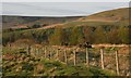
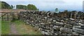
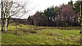
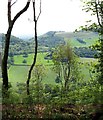
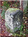
Three bronze age round barrows in close proximity to one another – However in reality whilst there may still may be traces, one of them has now gone. They are in very prominent positions on what, at this point is gently sloping ground on a spur which projects westward from the Hambleton Hills above the village of Kepwick.
Referring to the uploaded sketch map:
Barrow ‘A’ at SE 47391 90225 – Official records describe this as made of earth and stone, 9m in diameter and 0.75m high. It doesn’t look anywhere near this height to me, its very much disturbed, spread out and denuded, however it was still recognisable for what it is and easy to locate.
Barrow ‘B’ at SE 47453 90251 – Though still of no great height (0.9m) it is the most prominent of the barrows and being at the northern edge of the spur its profile stood out clearly when I visited, however it looks like it might be bracken covered in the summer months. It is 10m in diameter.
Barrow ‘C’ at SE 4748 9016 – The map reference is from official records and was described in 1963 as being 2ft high and 15 to 18ft in diameter and already much disturbed by rabbits and people hunting for them. Today (2024) it has gone and does not show up on aerial archaeology mapping, it was descheduled in 1994. I myself first looked for it in 2014 and my layman's eye found nothing, consequently I never bothered with it after that, though I passed by this way several times. Perhaps an expert will see traces and indeed it is still marked as a cairn on the present day (2024) 1:25 OS map as are the other two barrows. I myself also get the impression that it was never of much consequence, before finally disappearing, for example it does not show at all on the historical 1857 OS map whilst both the other barrows are identified. See HERE, when the map opens, zoom in to the left hand centre of the map and locate Black Hill, just to the left of that, though obscured you will see the word Penhill Gate and above and to the left of that, the two Tumuli designated ‘A’ and ‘B’ on this site page. ‘C’ is not shown.
Red Gate – The barrows sit beside an ancient route which runs from the village of Kepwick up the spur to join the HAMBLETON DROVE ROAD (Hambleton Street) which runs along the western edge of the Hambleton Hills. This route was known as Red Gate and was still marked as such on the 1857 map whose link is provided above as it passes by Gallow Hill on its way up the spur. This route will have had its origins in prehistoric times, these and other barrows along its route are evidence of this.
Sources:
Hayes R. H, 1988 - Old Roads and Pannierways in North East Yorkshire Page 49.
HERR MONUMENT 55733
Historic England LIST ENTRY 1008583 and LIST ENTRY 1008584
You may be viewing yesterday's version of this page. To see the most up to date information please register for a free account.
")
")
Do not use the above information on other web sites or publications without permission of the contributor.
Nearby Images from Geograph Britain and Ireland:
©2007(licence)
©2022(licence)
©2011(licence)
©2019(licence)
©2019(licence)
The above images may not be of the site on this page, they are loaded from Geograph.
Please Submit an Image of this site or go out and take one for us!
Click here to see more info for this site
Nearby sites
Key: Red: member's photo, Blue: 3rd party photo, Yellow: other image, Green: no photo - please go there and take one, Grey: site destroyed
Download sites to:
KML (Google Earth)
GPX (GPS waypoints)
CSV (Garmin/Navman)
CSV (Excel)
To unlock full downloads you need to sign up as a Contributory Member. Otherwise downloads are limited to 50 sites.
Turn off the page maps and other distractions
Nearby sites listing. In the following links * = Image available
839m ESE 118° Gallow Hill Tumuli (Cowesby Moor)* Round Barrow(s) (SE4819789858)
1.4km ESE 105° Friar's Cross (Kepwick)* Ancient Cross (SE4879589908)
1.7km E 88° Kepwick Long Barrow* Long Barrow (SE4915590333)
2.0km E 93° Steeple Cross (Arden Little Moor)* Ancient Cross (SE4950490155)
3.3km ENE 60° Harker Yates Ridge (Arden Great Moor)* Round Barrow(s) (SE5032691940)
3.3km NNE 31° Whitestones (Arden Great Moor)* Round Barrow(s) (SE4916393116)
4.0km N 10° Black Hambleton* Round Barrow(s) (SE4808994185)
4.1km W 276° St Mary (Leake)* Ancient Cross (SE43329063)
4.7km ENE 58° Sun Bank (Arden Great Moor)* Round Barrow(s) (SE5136892782)
4.7km NNW 329° Hanging Stone (Thimbleby Bank)* Rock Outcrop (SE4501694270)
4.8km ENE 61° Sun Burnt Nab (Arden Great Moor)* Round Barrow(s) (SE5160292649)
5.0km W 262° St. Helen's Well (Borrowby) Holy Well or Sacred Spring (SE425895)
5.0km N 356° Thimbleby Nine Stones* Standing Stones (SE47099527)
5.4km N 6° Cray Hall Stone* Marker Stone (SE4797895674)
5.5km NNE 12° Robinsons Cross* Ancient Cross (SE4854895631)
5.5km SE 146° Boltby Scar Camp Hillfort (SE506857)
5.6km N 356° Thimbleby Moor 4* Rock Art (SE4700895837)
5.7km S 188° Howe Hill (Felixkirk)* Round Barrow(s) (SE46738463)
5.7km N 351° Thimbleby Moor 2* Rock Art (SE4652595928)
5.8km N 352° Thimbleby Moor 3* Rock Art (SE4656395961)
5.8km N 350° Thimbleby Moor 1* Rock Art (SE4639695988)
6.0km NE 45° Cow Ridge South West RB1* Round Barrow(s) (SE5167594565)
6.1km SE 145° Hambleton Down North* Round Barrow(s) (SE5102885301)
6.2km E 96° All Saints Church, Hawnby* Ancient Cross (SE53658967)
6.3km NNE 13° Miley Pike* Round Barrow(s) (SE48769642)
View more nearby sites and additional images


 We would like to know more about this location. Please feel free to add a brief description and any relevant information in your own language.
 Wir möchten mehr über diese Stätte erfahren. Bitte zögern Sie nicht, eine kurze Beschreibung und relevante Informationen in Deutsch hinzuzufügen.
 Nous aimerions en savoir encore un peu sur les lieux. S'il vous plaît n'hesitez pas à ajouter une courte description et tous les renseignements pertinents dans votre propre langue.
 Quisieramos informarnos un poco más de las lugares. No dude en añadir una breve descripción y otros datos relevantes en su propio idioma.