<< Our Photo Pages >> Hartwell Springs - Holy Well or Sacred Spring in England in Buckinghamshire
Submitted by DavidCWoods on Sunday, 10 March 2013 Page Views: 26573
Springs and Holy WellsSite Name: Hartwell Springs Alternative Name: Egyptian WellCountry: England County: Buckinghamshire Type: Holy Well or Sacred Spring
Nearest Town: Aylesbury Nearest Village: Hartwell
Map Ref: SP7939412589
Latitude: 51.806313N Longitude: 0.849887W
Condition:
| 5 | Perfect |
| 4 | Almost Perfect |
| 3 | Reasonable but with some damage |
| 2 | Ruined but still recognisable as an ancient site |
| 1 | Pretty much destroyed, possibly visible as crop marks |
| 0 | No data. |
| -1 | Completely destroyed |
| 5 | Superb |
| 4 | Good |
| 3 | Ordinary |
| 2 | Not Good |
| 1 | Awful |
| 0 | No data. |
| 5 | Can be driven to, probably with disabled access |
| 4 | Short walk on a footpath |
| 3 | Requiring a bit more of a walk |
| 2 | A long walk |
| 1 | In the middle of nowhere, a nightmare to find |
| 0 | No data. |
| 5 | co-ordinates taken by GPS or official recorded co-ordinates |
| 4 | co-ordinates scaled from a detailed map |
| 3 | co-ordinates scaled from a bad map |
| 2 | co-ordinates of the nearest village |
| 1 | co-ordinates of the nearest town |
| 0 | no data |
Internal Links:
External Links:
I have visited· I would like to visit
Lana would like to visit
")
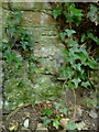
The local village is named for the well, which may now be found down a peaceful country lane (marked as a dead end). I visited in July 2005 and the water emerges from a small pipe from the bank beside the road.
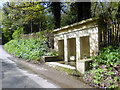
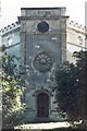
Opposite the Hartwell is a grandiose structure known as the Egyptian Well. Benches line the walls, and at the front of the building was a small recess containing the water.
Note: A very good introductory article about holy wells by Gerry Palmer, followed by a look at some to be found around Marlow and High Wycombe
You may be viewing yesterday's version of this page. To see the most up to date information please register for a free account.
")
")
Do not use the above information on other web sites or publications without permission of the contributor.
Andy B has found this location on Google Street View:
Nearby Images from Geograph Britain and Ireland:
©2013(licence)
©2010(licence)
©2013(licence)
©2009(licence)
©2008(licence)
The above images may not be of the site on this page, they are loaded from Geograph.
Please Submit an Image of this site or go out and take one for us!
Click here to see more info for this site
Nearby sites
Key: Red: member's photo, Blue: 3rd party photo, Yellow: other image, Green: no photo - please go there and take one, Grey: site destroyed
Download sites to:
KML (Google Earth)
GPX (GPS waypoints)
CSV (Garmin/Navman)
CSV (Excel)
To unlock full downloads you need to sign up as a Contributory Member. Otherwise downloads are limited to 50 sites.
Turn off the page maps and other distractions
Nearby sites listing. In the following links * = Image available
4.9km ENE 59° St. Osyth's Well (Bierton)* Holy Well or Sacred Spring (SP836152)
5.9km WSW 250° Cuddington Spring Holy Well or Sacred Spring (SP739105)
7.4km SSE 154° Ragpit Hill Cross Dyke Misc. Earthwork (SP82750601)
7.4km SSE 154° Ragpit Cross Dykes Misc. Earthwork (SP82750600)
7.5km SSE 152° Ragpit Cross Dyke Misc. Earthwork (SP83020598)
7.9km WSW 254° Stock Well (Chearsley)* Holy Well or Sacred Spring (SP718103)
8.1km N 5° Fair Alice well Holy Well or Sacred Spring (SP800207)
8.1km N 6° Whittle Hole* Holy Well or Sacred Spring (SP801207)
8.2km N 9° Holy Well (Whitchurch)* Holy Well or Sacred Spring (SP805207)
8.3km N 9° Whitchurch Holy Well Holy Well or Sacred Spring (SP806208)
8.5km SSE 154° Pulpit Hill* Hillfort (SP832050)
8.7km SE 130° Bacombe Hill Bowl Barrow Round Barrow(s) (SP86130709)
8.7km SE 130° Bacombe Hill Barrow Cemetery (SP86160712)
9.1km SSE 163° Whiteleaf Barrows* Long Barrow (SP82220398)
9.3km S 171° Princes Risborough Puddingstone* Natural Stone / Erratic / Other Natural Feature (SP80970338)
9.9km ESE 118° Boddington Camp* Hillfort (SP882080)
10.1km N 351° Scorne Well* Holy Well or Sacred Spring (SP777225)
10.5km S 190° The Lyde Spring* Holy Well or Sacred Spring (SP778022)
11.7km S 191° The Cop (Chinnor) Round Barrow(s) (SP773011)
12.2km S 183° Lodge Hill Barrows Round Barrow(s) (SP78840041)
12.2km SSW 193° Chinnor Hill Barrows* Round Barrow(s) (SP76760063)
12.3km SSE 150° Grim's Ditch Barrows Round Barrow(s) (SP857020)
12.5km S 181° Lodge Hill Round Barrow(s) (SP79400004)
12.7km S 181° Lodge Hill Settlement Ancient Village or Settlement (SU79479990)
13.4km NNW 333° Botyl Well* Holy Well or Sacred Spring (SP732245)
View more nearby sites and additional images


 We would like to know more about this location. Please feel free to add a brief description and any relevant information in your own language.
 Wir möchten mehr über diese Stätte erfahren. Bitte zögern Sie nicht, eine kurze Beschreibung und relevante Informationen in Deutsch hinzuzufügen.
 Nous aimerions en savoir encore un peu sur les lieux. S'il vous plaît n'hesitez pas à ajouter une courte description et tous les renseignements pertinents dans votre propre langue.
 Quisieramos informarnos un poco más de las lugares. No dude en añadir una breve descripción y otros datos relevantes en su propio idioma.