 with our Megalithic Portal iPhone app")

<< Text Pages >> St. Cuthman's Stone - Standing Stone (Menhir) in England in West Sussex
Submitted by Andy B on Wednesday, 25 May 2022 Page Views: 538
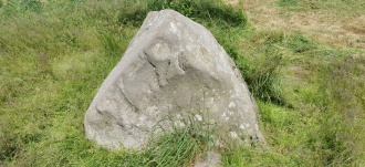
Neolithic and Bronze AgeSite Name: St. Cuthman's StoneCountry: England
NOTE: This site is 1.582 km away from the location you searched for.
County: West Sussex Type: Standing Stone (Menhir)
Map Ref: SU793027
Latitude: 50.818426N Longitude: 0.875655W
Condition:
| 5 | Perfect |
| 4 | Almost Perfect |
| 3 | Reasonable but with some damage |
| 2 | Ruined but still recognisable as an ancient site |
| 1 | Pretty much destroyed, possibly visible as crop marks |
| 0 | No data. |
| -1 | Completely destroyed |
| 5 | Superb |
| 4 | Good |
| 3 | Ordinary |
| 2 | Not Good |
| 1 | Awful |
| 0 | No data. |
| 5 | Can be driven to, probably with disabled access |
| 4 | Short walk on a footpath |
| 3 | Requiring a bit more of a walk |
| 2 | A long walk |
| 1 | In the middle of nowhere, a nightmare to find |
| 0 | No data. |
| 5 | co-ordinates taken by GPS or official recorded co-ordinates |
| 4 | co-ordinates scaled from a detailed map |
| 3 | co-ordinates scaled from a bad map |
| 2 | co-ordinates of the nearest village |
| 1 | co-ordinates of the nearest town |
| 0 | no data |
Internal Links:
External Links:
Though there is no conclusive proof of whatever stone or stones the name Steyning refer to, another stone is mentioned in old stories written about St. Cuthman, who is linked to the beginnings of the Saxon settlement at Steyning. St. Cuthman was born to Christian parents near the village of Chidham, West Sussex in the 7th or 8th century. He was given the responsibility of tending his fathers flock of sheep, and when he had to go and eat, he used to draw a circle around the flock and command them in the name of god to stay within the bounds of the circle, which of course they did.
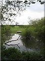
The stories also tell us this about the field in which the flock resided : "In the pasture there was a stone on which the holy shepherd was in the habit of sitting, which the locals still hold in great veneration today, for God brings many blessings through it by his merits" (Blair 1997 p.175). A possible location for this field is given in a Chidham glebe document dated 1635 which gives an acre of land south of Chidham as "St. Culman's feild" and within it, "St. Cullman's Dell". This field and the pond within it are at SU793027 (Blair 1997 p.181). When his father died, he took his infirm mother to what is now Steyning and built a wooden church there, presumably on the site of the current church, but that is another story.
You may be viewing yesterday's version of this page. To see the most up to date information please register for a free account.
Do not use the above information on other web sites or publications without permission of the contributor.
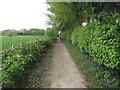
Nearby Images from Geograph Britain and Ireland:
©2010(licence)
©2011(licence)
©2011(licence)
©2009(licence)
©2014(licence)
The above images may not be of the site on this page, they are loaded from Geograph.
Please Submit an Image of this site or go out and take one for us!
Click here to see more info for this site
Nearby sites
Key: Red: member's photo, Blue: 3rd party photo, Yellow: other image, Green: no photo - please go there and take one, Grey: site destroyed
Download sites to:
KML (Google Earth)
GPX (GPS waypoints)
CSV (Garmin/Navman)
CSV (Excel)
To unlock full downloads you need to sign up as a Contributory Member. Otherwise downloads are limited to 50 sites.
Turn off the page maps and other distractions
Nearby sites listing. In the following links * = Image available
5.3km ENE 71° Fishbourne Roman Palace and Gardens* Ancient Palace (SU8430504531)
6.7km WSW 246° Tournerbury Hillfort (SZ7321799858)
6.9km ENE 72° The Novium* Museum (SU8590604914)
7.2km ENE 58° Brandy Hole Earthwork* Misc. Earthwork (SU854066)
7.8km ENE 64° Graylingwell Earthwork* Misc. Earthwork (SU863062)
8.1km NNE 18° Yew Tree Grove Cross Dyke Misc. Earthwork (SU817104)
8.2km N 11° Adsdean Down Tumuli* Barrow Cemetery (SU80751075)
8.4km NNE 21° Kingley Vale Settlements Ancient Village or Settlement (SU822106)
8.8km NNE 19° Devil's Humps Barrows* Barrow Cemetery (SU820111)
8.8km NNE 17° Bow Hill Cross Dykes* Misc. Earthwork (SU817112)
9.4km NNE 21° Bow Hill Cross Dykes and Earthwork Misc. Earthwork (SU825115)
9.5km WNW 294° St. Chad's Well (Bedhampton)* Holy Well or Sacred Spring (SU7061306477)
9.9km NNE 19° Stoughton Long Barrows* Long Barrow (SU823121)
9.9km NNE 19° Stoughton Down Tumulus Round Barrow(s) (SU824121)
10.6km NNE 21° Goosehill Camp* Hillfort (SU830126)
10.7km NE 49° Lavant Down Earthworks Misc. Earthwork (SU873098)
11.0km NE 51° Lavant Down Flint Mines Ancient Mine, Quarry or other Industry (SU877098)
11.8km NE 44° St Roche's Gate Cross Dyke* Misc. Earthwork (SU874113)
11.9km NE 45° The Trundle* Hillfort (SU877112)
12.4km ENE 64° Devils Ditch* Misc. Earthwork (SU904084)
12.8km N 358° Bevis Thumb* Long Barrow (SU7875415513)
13.1km N 3° Handle Down South Round Barrow(s) (SU7967815765)
13.5km N 3° Handle Down Central* Round Barrow(s) (SU79691619)
13.7km N 2° Handle Down North* Round Barrow(s) (SU7963616421)
13.8km NE 53° Molecomb Peak Tumulus Round Barrow(s) (SU902112)
View more nearby sites and additional images


 We would like to know more about this location. Please feel free to add a brief description and any relevant information in your own language.
 Wir möchten mehr über diese Stätte erfahren. Bitte zögern Sie nicht, eine kurze Beschreibung und relevante Informationen in Deutsch hinzuzufügen.
 Nous aimerions en savoir encore un peu sur les lieux. S'il vous plaît n'hesitez pas à ajouter une courte description et tous les renseignements pertinents dans votre propre langue.
 Quisieramos informarnos un poco más de las lugares. No dude en añadir una breve descripción y otros datos relevantes en su propio idioma.