<< Our Photo Pages >> St. Osyth's Well (Bierton) - Holy Well or Sacred Spring in England in Buckinghamshire
Submitted by DavidCWoods on Friday, 26 November 2004 Page Views: 12524
Springs and Holy WellsSite Name: St. Osyth's Well (Bierton)Country: England
NOTE: This site is 2.845 km away from the location you searched for.
County: Buckinghamshire Type: Holy Well or Sacred Spring
Nearest Town: Aylesbury Nearest Village: Bierton
Map Ref: SP836152
Latitude: 51.829171N Longitude: 0.788269W
Condition:
| 5 | Perfect |
| 4 | Almost Perfect |
| 3 | Reasonable but with some damage |
| 2 | Ruined but still recognisable as an ancient site |
| 1 | Pretty much destroyed, possibly visible as crop marks |
| 0 | No data. |
| -1 | Completely destroyed |
| 5 | Superb |
| 4 | Good |
| 3 | Ordinary |
| 2 | Not Good |
| 1 | Awful |
| 0 | No data. |
| 5 | Can be driven to, probably with disabled access |
| 4 | Short walk on a footpath |
| 3 | Requiring a bit more of a walk |
| 2 | A long walk |
| 1 | In the middle of nowhere, a nightmare to find |
| 0 | No data. |
| 5 | co-ordinates taken by GPS or official recorded co-ordinates |
| 4 | co-ordinates scaled from a detailed map |
| 3 | co-ordinates scaled from a bad map |
| 2 | co-ordinates of the nearest village |
| 1 | co-ordinates of the nearest town |
| 0 | no data |
Internal Links:
External Links:
 (PID:10793)")
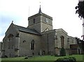
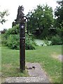
The dedication to St. Osyth, an Essex princess, is attributed on the notice nearby to her connection with wells - the church's to St. James has been ascribed to the fact that he is the patron saint of pilgrims, suggesting that the well may have been a source of pilgramage before the church was built.
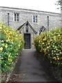
Reported as being next to the church of St. James the Great, I walked round the churchyard without success. Well Cottage is just to the north of the church but no signs there either. Eventually tried the local pub, and was given directions - past the church to the south for a few yards the take the turning on the left down hill.
You may be viewing yesterday's version of this page. To see the most up to date information please register for a free account. (PID:10798)")
 (PID:10794)")
Do not use the above information on other web sites or publications without permission of the contributor.
Nearby Images from Geograph Britain and Ireland:
©2006(licence)
©2006(licence)
©2006(licence)
©2006(licence)
©2006(licence)
The above images may not be of the site on this page, they are loaded from Geograph.
Please Submit an Image of this site or go out and take one for us!
Click here to see more info for this site
Nearby sites
Key: Red: member's photo, Blue: 3rd party photo, Yellow: other image, Green: no photo - please go there and take one, Grey: site destroyed
Download sites to:
KML (Google Earth)
GPX (GPS waypoints)
CSV (Garmin/Navman)
CSV (Excel)
To unlock full downloads you need to sign up as a Contributory Member. Otherwise downloads are limited to 50 sites.
Turn off the page maps and other distractions
Nearby sites listing. In the following links * = Image available
4.9km WSW 239° Hartwell Springs* Holy Well or Sacred Spring (SP7939412589)
6.3km NNW 332° Holy Well (Whitchurch)* Holy Well or Sacred Spring (SP805207)
6.3km NNW 333° Whitchurch Holy Well Holy Well or Sacred Spring (SP806208)
6.5km NNW 329° Whittle Hole* Holy Well or Sacred Spring (SP801207)
6.6km NNW 328° Fair Alice well Holy Well or Sacred Spring (SP800207)
8.5km SSE 163° Bacombe Hill Barrow Cemetery (SP86160712)
8.5km SSE 164° Bacombe Hill Bowl Barrow Round Barrow(s) (SP86130709)
8.5km SSE 148° Boddington Camp* Hillfort (SP882080)
9.2km S 186° Ragpit Hill Cross Dyke Misc. Earthwork (SP82750601)
9.2km S 185° Ragpit Cross Dyke Misc. Earthwork (SP83020598)
9.2km S 186° Ragpit Cross Dykes Misc. Earthwork (SP82750600)
9.4km NW 322° Scorne Well* Holy Well or Sacred Spring (SP777225)
10.2km S 183° Pulpit Hill* Hillfort (SP832050)
10.8km WSW 245° Cuddington Spring Holy Well or Sacred Spring (SP739105)
10.8km E 96° Northfield Settlement Ancient Village or Settlement (SP944143)
11.3km S 188° Whiteleaf Barrows* Long Barrow (SP82220398)
11.3km E 96° Pitstone Hill Causewayed Enclosure (SP949142)
11.6km E 101° Aldbury Nowers Round Barrow(s) (SP95071324)
11.8km ESE 121° Grim’s Ditch (Hertfordshire) Misc. Earthwork (SP93850938)
12.1km SSW 193° Princes Risborough Puddingstone* Natural Stone / Erratic / Other Natural Feature (SP80970338)
12.3km SE 131° Cholesbury Camp* Hillfort (SP930072)
12.4km E 85° Ivinghoe Beacon Hill Barrows* Barrow Cemetery (SP95961638)
12.5km E 83° Ivinghoe Beacon* Hillfort (SP960169)
12.7km WSW 248° Stock Well (Chearsley)* Holy Well or Sacred Spring (SP718103)
12.8km NNE 22° Soulbury Stone* Natural Stone / Erratic / Other Natural Feature (SP88292709)
View more nearby sites and additional images


 We would like to know more about this location. Please feel free to add a brief description and any relevant information in your own language.
 Wir möchten mehr über diese Stätte erfahren. Bitte zögern Sie nicht, eine kurze Beschreibung und relevante Informationen in Deutsch hinzuzufügen.
 Nous aimerions en savoir encore un peu sur les lieux. S'il vous plaît n'hesitez pas à ajouter une courte description et tous les renseignements pertinents dans votre propre langue.
 Quisieramos informarnos un poco más de las lugares. No dude en añadir una breve descripción y otros datos relevantes en su propio idioma.