


<< Our Photo Pages >> Newcote Round Barrow - Barrow Cemetery in England in Yorkshire (East)
Submitted by cavers35 on Tuesday, 04 April 2023 Page Views: 391
Neolithic and Bronze AgeSite Name: Newcote Round BarrowCountry: England
NOTE: This site is 2.789 km away from the location you searched for.
County: Yorkshire (East) Type: Barrow Cemetery
Nearest Town: Pocklington Nearest Village: Warter
Map Ref: SE84225085
Latitude: 53.946910N Longitude: 0.718295W
Condition:
| 5 | Perfect |
| 4 | Almost Perfect |
| 3 | Reasonable but with some damage |
| 2 | Ruined but still recognisable as an ancient site |
| 1 | Pretty much destroyed, possibly visible as crop marks |
| 0 | No data. |
| -1 | Completely destroyed |
| 5 | Superb |
| 4 | Good |
| 3 | Ordinary |
| 2 | Not Good |
| 1 | Awful |
| 0 | No data. |
| 5 | Can be driven to, probably with disabled access |
| 4 | Short walk on a footpath |
| 3 | Requiring a bit more of a walk |
| 2 | A long walk |
| 1 | In the middle of nowhere, a nightmare to find |
| 0 | No data. |
| 5 | co-ordinates taken by GPS or official recorded co-ordinates |
| 4 | co-ordinates scaled from a detailed map |
| 3 | co-ordinates scaled from a bad map |
| 2 | co-ordinates of the nearest village |
| 1 | co-ordinates of the nearest town |
| 0 | no data |
Internal Links:
External Links:
")
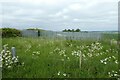
This round barrow is situated on an imposing spot at the top of Newcote Fields in the high wolds landscape, with spectacular views all around it. It's 22m in diameter and almost 3 metres high.
It's a scheduled monument listing 21117 and the Ordnance Survey have used it to site their Trig Point. Historic England details
There's a comprehensive listing on Chris Collyer's website
You may be viewing yesterday's version of this page. To see the most up to date information please register for a free account.
")
")
")
Do not use the above information on other web sites or publications without permission of the contributor.
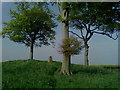
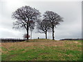
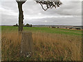
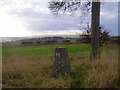
Nearby Images from Geograph Britain and Ireland:
©2007(licence)
©2018(licence)
©2010(licence)
©2009(licence)
©2022(licence)
The above images may not be of the site on this page, they are loaded from Geograph.
Please Submit an Image of this site or go out and take one for us!
Click here to see more info for this site
Nearby sites
Key: Red: member's photo, Blue: 3rd party photo, Yellow: other image, Green: no photo - please go there and take one, Grey: site destroyed
Download sites to:
KML (Google Earth)
GPX (GPS waypoints)
CSV (Garmin/Navman)
CSV (Excel)
To unlock full downloads you need to sign up as a Contributory Member. Otherwise downloads are limited to 50 sites.
Turn off the page maps and other distractions
Nearby sites listing. In the following links * = Image available
1.3km SSW 207° Kilnwick Percy Hill - Barrow* Barrow Cemetery (SE8365149674)
3.1km S 171° St James Church (Nunburnholme)* Ancient Cross (SE84774779)
3.4km ENE 61° Dearsden Hill Hillfort (SE872526)
6.1km SSE 155° All Saints (Londesborough)* Ancient Cross (SE86864538)
6.5km NNW 343° Callis Wold Barrow Cemetery* Barrow Cemetery (SE8217857003)
7.9km NNE 33° Fridaythorpe Earthworks* Misc. Earthwork (SE88425753)
8.8km NNW 342° Kirby Underdale Cursus Cursus (SE81355922)
9.0km SSE 151° Lady Well (Goodmanham)* Holy Well or Sacred Spring (SE887430)
9.7km SSE 152° St Helen's Well (Goodmanham)* Holy Well or Sacred Spring (SE890424)
10.4km NNW 343° Hanging Grimstone Barrow Cemetery (SE810608)
11.4km NNE 28° Fimber Cursus Cursus (SE894610)
11.5km NNW 341° Acklam Wold Cemetery* Barrow Cemetery (SE8027061693)
12.0km NNE 34° Fimber Cursus* Cursus (SE907610)
12.0km SSW 210° Lady Well (Seaton Ross) Holy Well or Sacred Spring (SE784403)
12.3km WNW 283° Catton Cursus (SE721534)
12.6km NNE 18° Towthorpe Plantation Barrow Cemetery Barrow Cemetery (SE879629)
12.8km N 359° Wharram Percy Barrows Barrow Cemetery (SE837636)
12.8km NNE 14° Fairy Stones* Natural Stone / Erratic / Other Natural Feature (SE8700363317)
12.8km W 281° Catton Cursus (SE716530)
13.0km SE 139° Arras Barrow Cemetery* Barrow Cemetery (SE930413)
13.4km NNE 17° High Street Barrow (Towthorpe) Cairn (SE88006373)
14.9km ENE 74° Mill Hill (Eastburn) Cairn (SE98545525)
15.1km ENE 78° Southburn Archaeological Museum Museum (SE98965435)
15.2km ENE 65° Garton Slack 81 Round Barrow(s) (SE97905755)
15.2km ENE 64° Garton Slack 80 Round Barrow(s) (SE97815773)
View more nearby sites and additional images


 We would like to know more about this location. Please feel free to add a brief description and any relevant information in your own language.
 Wir möchten mehr über diese Stätte erfahren. Bitte zögern Sie nicht, eine kurze Beschreibung und relevante Informationen in Deutsch hinzuzufügen.
 Nous aimerions en savoir encore un peu sur les lieux. S'il vous plaît n'hesitez pas à ajouter une courte description et tous les renseignements pertinents dans votre propre langue.
 Quisieramos informarnos un poco más de las lugares. No dude en añadir una breve descripción y otros datos relevantes en su propio idioma.