<< Our Photo Pages >> Tarry Stone - Marker Stone in England in Berkshire
Submitted by NickyD on Sunday, 18 October 2015 Page Views: 9510
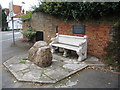
Multi-periodSite Name: Tarry Stone Alternative Name: Cookham Stone; TarrystoneCountry: England County: Berkshire Type: Marker Stone
Nearest Town: Maidenhead Nearest Village: Cookham
Map Ref: SU8974585392
Latitude: 51.560279N Longitude: 0.706781W
Condition:
| 5 | Perfect |
| 4 | Almost Perfect |
| 3 | Reasonable but with some damage |
| 2 | Ruined but still recognisable as an ancient site |
| 1 | Pretty much destroyed, possibly visible as crop marks |
| 0 | No data. |
| -1 | Completely destroyed |
| 5 | Superb |
| 4 | Good |
| 3 | Ordinary |
| 2 | Not Good |
| 1 | Awful |
| 0 | No data. |
| 5 | Can be driven to, probably with disabled access |
| 4 | Short walk on a footpath |
| 3 | Requiring a bit more of a walk |
| 2 | A long walk |
| 1 | In the middle of nowhere, a nightmare to find |
| 0 | No data. |
| 5 | co-ordinates taken by GPS or official recorded co-ordinates |
| 4 | co-ordinates scaled from a detailed map |
| 3 | co-ordinates scaled from a bad map |
| 2 | co-ordinates of the nearest village |
| 1 | co-ordinates of the nearest town |
| 0 | no data |
Internal Links:
External Links:
I have visited· I would like to visit
NickyD visited on 1st Jan 1985 - their rating: Cond: 4 Amb: 2 Access: 5
")
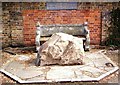
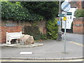
In the book, Thames: Sacred River by Peter Ackroyd the Tarry Stone and Cookham Stone are mentioned. The Tarry Stone is claimed in the book to be a meteorite. Being made of sarsen this is unlikely.
Further reading: http://www.celiahaddon.co.uk/standing%20stones/berkshire.htm (Archived) and http://www.cookham.com/about/history/history1.htm
Original page by Coldrum
Update January 2018: This boundary stone is also featured on The Northern Antiquarian (TNA) - see their entry for Tarry Stone, Cookham, Berkshire, which gives directions for finding this stone, together with a photograph, an image of an old postcard of the stone and its location, a drawing from 1976, descriptions from historical sources and local folklore.
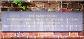
The stone is also recorded as Pastscape Monument No. 248193, which estimates the date to the 16th century, adding: "The Tarry Stone is now incorporated in a War memorial at SU 89748539. It is an irregular block of stone with a plaque bearing the following inscription "The Tarry Stone at which sports were held before AD.1507. Stood formerly 50 yds N.N.E. and was replaced here AD 1909...." Its 1909 position was at SU 89718534, where it is described as "Stone" on the O.S. 25" 1933. An intermediate site was a private garden ... but it is evidently now approximately in its original position."
You may be viewing yesterday's version of this page. To see the most up to date information please register for a free account.
")
Do not use the above information on other web sites or publications without permission of the contributor.
Nearby Images from Geograph Britain and Ireland:
©2020(licence)
©2020(licence)
©2008(licence)
©2014(licence)
©2010(licence)
The above images may not be of the site on this page, they are loaded from Geograph.
Please Submit an Image of this site or go out and take one for us!
Click here to see more info for this site
Nearby sites
Key: Red: member's photo, Blue: 3rd party photo, Yellow: other image, Green: no photo - please go there and take one, Grey: site destroyed
Download sites to:
KML (Google Earth)
GPX (GPS waypoints)
CSV (Garmin/Navman)
CSV (Excel)
To unlock full downloads you need to sign up as a Contributory Member. Otherwise downloads are limited to 50 sites.
Turn off the page maps and other distractions
Nearby sites listing. In the following links * = Image available
2.7km E 84° Root Mound Round Barrow(s) (SU92438574)
3.1km S 184° Bapsey Pond* Holy Well or Sacred Spring (SU896823)
3.3km SSE 166° Taplow Mound* Artificial Mound (SU90618216)
5.0km E 99° Seven Ways Plain* Hillfort (SU94718466)
5.0km W 260° Princess Elizabeth's Well* Holy Well or Sacred Spring (SU848844)
6.3km SW 228° Robin Hood's Arbour* Ancient Village or Settlement (SU85188108)
6.3km W 267° Low Grounds Farm Barrow Cemetery (SU834849)
6.5km S 170° Weir Bank Stud Farm Ancient Village or Settlement (SU90957900)
6.8km SW 225° Maidenhead Thicket Bowl Barrow* Round Barrow(s) (SU850805)
7.1km NNW 341° Keep Hill Hillfort (SU87379205)
7.9km ESE 115° Stoke Park Bowl Barrow* Round Barrow(s) (SU97038222)
8.0km NE 47° The Mount (Beaconsfield)* Round Barrow(s) (SU95549089)
8.0km W 264° Danesfield Camp* Hillfort (SU81768440)
8.7km SE 129° Montem mound Artificial Mound (SU9665880045)
9.1km W 266° Medmenham Camp* Hillfort (SU80698467)
9.4km NNW 329° Desborough Castle* Hillfort (SU847933)
10.0km ENE 76° Bulstrode Camp* Hillfort (SU994880)
10.9km WSW 244° Rebecca's Well (Crazies Hill)* Holy Well or Sacred Spring (SU7993080487)
11.7km NW 325° Church Hill Celtic Fields Misc. Earthwork (SU82809480)
11.9km NW 325° West Wycombe Camp* Hillfort (SU82769499)
12.2km NW 325° Celtic field system on Church Hill Misc. Earthwork (SU82559530)
12.3km NW 325° Church Hill Trackway Ancient Trackway (SU82469533)
12.4km WSW 252° Mont de la Ville* Passage Grave (SU77968140)
12.5km S 184° Holyport Modern Stone Circle Modern Stone Circle etc (SU8908672865)
13.6km NNW 330° Bradenham Puddingstone* Natural Stone / Erratic / Other Natural Feature (SU828971)
View more nearby sites and additional images


 We would like to know more about this location. Please feel free to add a brief description and any relevant information in your own language.
 Wir möchten mehr über diese Stätte erfahren. Bitte zögern Sie nicht, eine kurze Beschreibung und relevante Informationen in Deutsch hinzuzufügen.
 Nous aimerions en savoir encore un peu sur les lieux. S'il vous plaît n'hesitez pas à ajouter une courte description et tous les renseignements pertinents dans votre propre langue.
 Quisieramos informarnos un poco más de las lugares. No dude en añadir una breve descripción y otros datos relevantes en su propio idioma.