<< Our Photo Pages >> Fridaythorpe Earthworks - Misc. Earthwork in England in Yorkshire (East)

Submitted by SumDoood on Monday, 01 May 2017  Page Views: 3401

Multi-periodSite Name: Fridaythorpe Earthworks Alternative Name: Holm Dale, Horse Dale, Harper Dale
Country: England
NOTE: This site is 1.915 km away from the location you searched for.

County: Yorkshire (East) Type: Misc. Earthwork
 Nearest Village: Fridaythorpe
Map Ref: SE88425753
Latitude: 54.006232N  Longitude: 0.652387W
Condition:
5Perfect
4Almost Perfect
3Reasonable but with some damage
2Ruined but still recognisable as an ancient site
1Pretty much destroyed, possibly visible as crop marks
0No data.
-1Completely destroyed
3 Ambience:
5Superb
4Good
3Ordinary
2Not Good
1Awful
0No data.
4 Access:
5Can be driven to, probably with disabled access
4Short walk on a footpath
3Requiring a bit more of a walk
2A long walk
1In the middle of nowhere, a nightmare to find
0No data.
4 Accuracy:
5co-ordinates taken by GPS or official recorded co-ordinates
4co-ordinates scaled from a detailed map
3co-ordinates scaled from a bad map
2co-ordinates of the nearest village
1co-ordinates of the nearest town
0no data
4

Internal Links:
External Links:

Fridaythorpe Earthworks
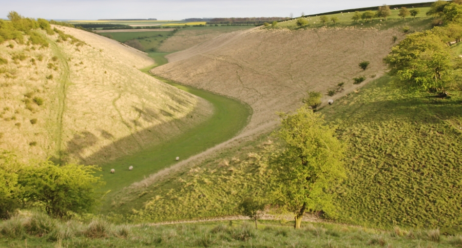
Fridaythorpe Earthworks submitted by SumDoood : This is Holm Dale, south of Fridaythorpe. Down at the end there is Harper Dale to the left and Horse Dale to the right. These dry valleys of the Yorkshire Wolds were created at the end of the last Ice Age, c.18,000 years ago, when the action of fast-running streams flowing over frozen ground carved out these valleys. The chalk geology here allows water to drain so efficiently that the valleys run ... (Vote or comment on this photo)
Misc. Earthwork in Yorkshire (East)

I'd come here on 22 April 2017 to find "Earthworks" which I'd seen on the Ordnance Survey's 1:50000 and 1:25000 maps. I'd read elsewhere that they were Bronze Age (though I was wondering if they were medieval).

This is Holm Dale, south of Fridaythorpe. Down at the end there is Harper Dale to the left and Horse Dale to the right. These dry valleys of the Yorkshire Wolds were created at the end of the last Ice Age, c.18,000 years ago, when the action of fast-running streams flowing over frozen ground carved out these valleys. The chalk geology here allows water to drain so efficiently that the valleys run dry.

I am open to alternative suggestions, but have *assumed* that the purpose of the "Earthworks" (essentially ditches - photos to follow - generally along the upper edges of the valleys), was to prevent / reduce topsoil run-off from the fields (nowadays prairie-style agro-industrial intensively farmed flat areas), either side of each of the valleys and also to maintain grazing on the steep deforested sides of the valleys.
You may be viewing yesterday's version of this page. To see the most up to date information please register for a free account.

Fridaythorpe Earthworks
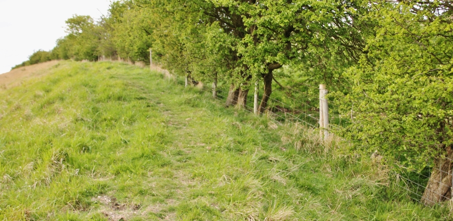
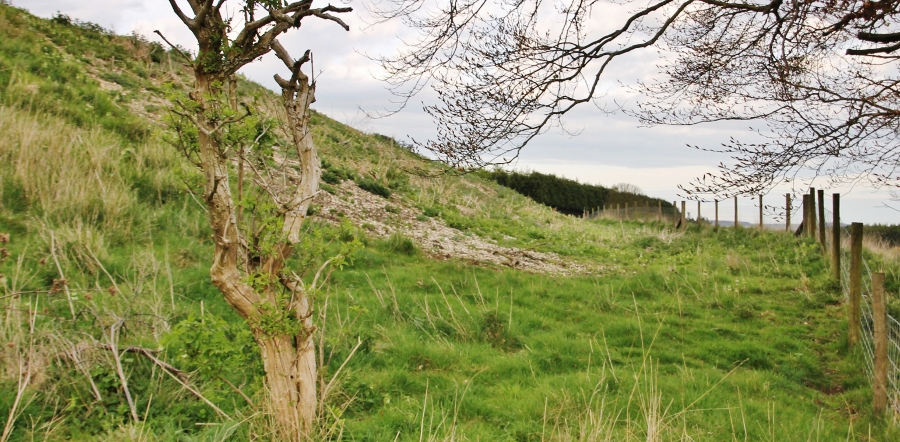
Fridaythorpe Earthworks submitted by SumDoood : In parts it is reminiscent of parts of Offa's Dyke. The earthworks extend over a considerable distance, but I suspect this location is fairly typical of them. Watch out for flints in the soil around the very numerous rabbit holes. (Vote or comment on this photo)

Fridaythorpe Earthworks
Fridaythorpe Earthworks submitted by SumDoood : Where the plateau meets the junction of the three valleys, the shoulder of the land drops more steeply than it does further away from the junction, and the ditch / ledge / earthwork is more obvious as it is here behind the hawthorn hedge. (Vote or comment on this photo)

Fridaythorpe Earthworks
Fridaythorpe Earthworks submitted by SumDoood : This is on the east side of Holm Dale close to where all three valleys meet. The earthwork forms a ledge here, rather than a ditch. To the left is the plateau, and to the right the steep descent into Harper Dale. (Vote or comment on this photo)

Fridaythorpe Earthworks
Fridaythorpe Earthworks submitted by SumDoood : This is on the east side of Holm Dale close to where all three valleys meet. Here the earthwork is about as obvious as it gets in the locality. Two ditches are meeting at this point, one behind the hedge, and the other crossing it at right angles in the foreground. (Vote or comment on this photo)

Fridaythorpe Earthworks
Fridaythorpe Earthworks submitted by SumDoood : If you drive south from Fridaythorpe down the unsurfaced track, you can park near where it forms a T (avoiding field entrances), then cross the stile, but don't go down into the valley bottom on the Wolds Way Long Distance Path. Follow the hedge on the east side of Holm Dale and sooner or later the earthwork will become obvious. In places it is a little more than a depression on the east side of t... (Vote or comment on this photo)

Fridaythorpe Earthworks
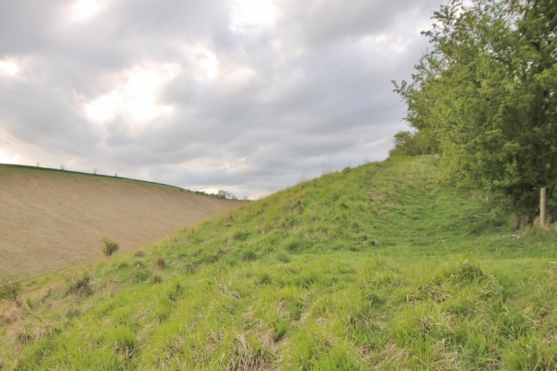
Fridaythorpe Earthworks submitted by SumDoood : Looking up the same valley northward to where the view at the top of this page was taken. I've included this partly to indicate that the earthworks aren't very obvious! At first.

Do not use the above information on other web sites or publications without permission of the contributor.
Click here to see more info for this site

Nearby sites

Click here to view sites on an interactive OS map

Key: Red: member's photo, Blue: 3rd party photo, Yellow: other image, Green: no photo - please go there and take one, Grey: site destroyed

Download sites to:
KML (Google Earth)
GPX (GPS waypoints)
CSV (Garmin/Navman)
CSV (Excel)

To unlock full downloads you need to sign up as a Contributory Member. Otherwise downloads are limited to 50 sites.


Turn off the page maps and other distractions

Nearby sites listing. In the following links * = Image available
 3.6km NNE 17° Fimber Cursus Cursus (SE894610)
 4.1km NE 34° Fimber Cursus* Cursus (SE907610)
 5.1km SSW 195° Dearsden Hill Hillfort (SE872526)
 5.4km N 356° Towthorpe Plantation Barrow Cemetery Barrow Cemetery (SE879629)
 6.0km NNW 347° Fairy Stones* Natural Stone / Erratic / Other Natural Feature (SE8700363317)
 6.2km N 357° High Street Barrow (Towthorpe) Cairn (SE88006373)
 6.2km W 266° Callis Wold Barrow Cemetery* Barrow Cemetery (SE8217857003)
 7.2km WNW 285° Kirby Underdale Cursus Cursus (SE81355922)
 7.7km NW 323° Wharram Percy Barrows Barrow Cemetery (SE837636)
 7.9km SSW 213° Newcote Round Barrow* Barrow Cemetery (SE84225085)
 8.1km WNW 295° Hanging Grimstone Barrow Cemetery (SE810608)
 9.1km WNW 298° Acklam Wold Cemetery* Barrow Cemetery (SE8027061693)
 9.2km SSW 212° Kilnwick Percy Hill - Barrow* Barrow Cemetery (SE8365149674)
 9.4km N 359° Duggleby Howe* Round Barrow(s) (SE88046688)
 9.4km E 90° Garton Slack 80 Round Barrow(s) (SE97815773)
 9.4km N 358° Duggleby Cursus Cursus (SE879669)
 9.5km E 91° Garton Slack 81 Round Barrow(s) (SE97905755)
 9.5km N 6° Duggleby Cursus Cursus (SE892670)
 10.3km ESE 104° Mill Hill (Eastburn) Cairn (SE98545525)
 10.4km SSW 202° St James Church (Nunburnholme)* Ancient Cross (SE84774779)
 10.9km NE 41° Willie Howe (Cowlam) Round Barrow(s) (SE95516586)
 11.0km ESE 108° Southburn Archaeological Museum Museum (SE98965435)
 11.7km NE 43° Kemp Howe (Yorkshire) Long Barrow (SE96166628)
 12.2km S 188° All Saints (Londesborough)* Ancient Cross (SE86864538)
 13.0km NE 38° Helperthorpe Long Barrow Long Barrow (SE963679)
View more nearby sites and additional images

<< Malgré Tout

Frederikssund Vikingeboplads >>

Please add your thoughts on this site

Before the Pyramids, Cracking Archaeology's Greatest Mystery by Knight & Butler

Before the Pyramids, Cracking Archaeology's Greatest Mystery by Knight &  Butler

Sponsors

Auto-Translation (Google)

Translate from English into:

"Fridaythorpe Earthworks" | Login/Create an Account | 6 News and Comments
  
Go back to top of page    Comments are owned by the poster. We aren't responsible for their content.
Re: Fridaythorpe Earthworks by SumDoood on Monday, 01 May 2017
(User Info | Send a Message)
Thank you, Anne.

Waves and Time isn't so far away, but it's modern, and not the place to which I've referred. And I'm told that Pastscape is far from 100% reliable, so I was not discouraged when unable to find these earthworks listed there. So far I'm happy to rely on the reference I remember seeing recently which calls these earthworks "Bronze Age" although it might have been in a walkers' guide, or similar website only.
[ Reply to This ]
    Re: Fridaythorpe Earthworks by Anne T on Monday, 01 May 2017
    (User Info | Send a Message)
    Hi, SumDood,

    Many thanks for clarifying this - and so quickly! - much appreciated. It looks like a fantastic place to walk, and very intriguing.

    Our local historic and environment officer always points me to Pastscape and Historic England if I ever have a query. I'll remember to take Pastscape with a 'pinch of salt' in future.

    Best wishes,
    Anne T.
    [ Reply to This ]
    Re: Fridaythorpe Earthworks by Andy B on Monday, 01 May 2017
    (User Info | Send a Message)
    I think what they mean by 'unreliable' is that the local council's HER should be the more accurate record, if you can get it online - in this case I think it's the Humber Archaeology Partnership which should be searchable as part of the Heritage Gateway

    http://www.heritagegateway.org.uk/gateway/chr/herdetail.aspx?crit=&ctid=92&id=4729
    [ Reply to This ]
      Re: Fridaythorpe Earthworks by SumDoood on Monday, 01 May 2017
      (User Info | Send a Message)
      Thank you, Andy. I've just searched on "Fridaythorpe" on the Humber website and clicked on every link that I think might have been relevant, but it seems none of them are "my" earthworks.
      [ Reply to This ]
        Re: Fridaythorpe Earthworks by Andy B on Monday, 01 May 2017
        (User Info | Send a Message)
        Did you search in the Heritage Gateway?
        http://www.heritagegateway.org.uk/Gateway/
        I find it horrible to use but it came up with 42 results for Humber - some of which are

        DITCH FRAGMENT FRIDAYTHORPE, EAST RIDING
        LINEAR DITCHES, TWO POSSIBLE ROUND BARROWS FRIDAYTHORPE, EAST RIDING
        POSSIBLE ROMAN ROAD FRIDAYTHORPE, EAST RIDING
        DITCH FRAGMENT FRIDAYTHORPE, EAST RIDING
        LINEAR EARTHWORK FRIDAYTHORPE, EAST RIDING
        LINEAR EARTHWORK FRIDAYTHORPE, EAST RIDING
        LINEAR EARTHWORK FRIDAYTHORPE, EAST RIDING
        LINEAR EARTHWORK FRIDAYTHORPE, EAST RIDING
        LINEAR EARTHWORK AND ENCLOSURE FRIDAYTHORPE, EAST RIDING
        DITCH FRAGMENTS, TWO RING DITCHES FRIDAYTHORPE, EAST RIDING
        LINEAR DOUBLE DYKE, FRIDAYTHORPE FIELD FRIDAYTHORPE, EAST RIDING
        LINEAR SOILMARKS FRIDAYTHORPE, EAST RIDING
        MEDIEVAL OPEN FIELD SYSTEMS, FRIDAYTHORPE PARISH FRIDAYTHORPE, EAST RIDING
        TWO LINEAR EARTHWORKS, WAN DALE/HAG DALE FRIDAYTHORPE, EAST RIDING
        LINEAR EARTHWORK, RAIN DALE FRIDAYTHORPE, EAST RIDING
        [ Reply to This ]

Re: Fridaythorpe Earthworks by Anne T on Monday, 01 May 2017
(User Info | Send a Message)
Hi, SumDood,

I was really intrigued by Fridaythorpe Earthworks, but couldn't find anything about it in Pastscape.

I did come across a reference to a modern earthwork: "Waves and Time" (previously called Time and Flow) - see Waves and Time by Chris Drury. On their slideshow just over half way down this page, they have a photograph which is almost identical to yours (OK, different time of year, and includes sheep!).

Is this the same spot?

Let me know if you want any different text against your photo.
Many thanks,
Anne T.
[ Reply to This ]

Your Name: Anonymous [ Register Now ]
Subject:


Add your comment or contribution to this page. Spam or offensive posts are deleted immediately, don't even bother

<<< What is five plus one as a number? (Please type the answer to this question in the little box on the left)
You can also embed videos and other things. For Youtube please copy and paste the 'embed code'.
For Google Street View please include Street View in the text.
Create a web link like this: <a href="https://www.megalithic.co.uk">This is a link</a>  

Allowed HTML is:
<p> <b> <i> <a> <img> <em> <br> <strong> <blockquote> <tt> <li> <ol> <ul> <object> <param> <embed> <iframe>

We would like to know more about this location. Please feel free to add a brief description and any relevant information in your own language.
Wir möchten mehr über diese Stätte erfahren. Bitte zögern Sie nicht, eine kurze Beschreibung und relevante Informationen in Deutsch hinzuzufügen.
Nous aimerions en savoir encore un peu sur les lieux. S'il vous plaît n'hesitez pas à ajouter une courte description et tous les renseignements pertinents dans votre propre langue.
Quisieramos informarnos un poco más de las lugares. No dude en añadir una breve descripción y otros datos relevantes en su propio idioma.