<< Our Photo Pages >> Kell Well (Walcot) - Holy Well or Sacred Spring in England in Lincolnshire
Submitted by HOLYWELL on Sunday, 27 February 2011 Page Views: 9384
Springs and Holy WellsSite Name: Kell Well (Walcot)Country: England
NOTE: This site is 3.712 km away from the location you searched for.
County: Lincolnshire Type: Holy Well or Sacred Spring
Nearest Town: Scunthorpe Nearest Village: ALKBOROUGH
Map Ref: SE873207
Latitude: 53.675487N Longitude: 0.67992W
Condition:
| 5 | Perfect |
| 4 | Almost Perfect |
| 3 | Reasonable but with some damage |
| 2 | Ruined but still recognisable as an ancient site |
| 1 | Pretty much destroyed, possibly visible as crop marks |
| 0 | No data. |
| -1 | Completely destroyed |
| 5 | Superb |
| 4 | Good |
| 3 | Ordinary |
| 2 | Not Good |
| 1 | Awful |
| 0 | No data. |
| 5 | Can be driven to, probably with disabled access |
| 4 | Short walk on a footpath |
| 3 | Requiring a bit more of a walk |
| 2 | A long walk |
| 1 | In the middle of nowhere, a nightmare to find |
| 0 | No data. |
| 5 | co-ordinates taken by GPS or official recorded co-ordinates |
| 4 | co-ordinates scaled from a detailed map |
| 3 | co-ordinates scaled from a bad map |
| 2 | co-ordinates of the nearest village |
| 1 | co-ordinates of the nearest town |
| 0 | no data |
Internal Links:
External Links:
 (PID:115319)")
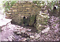
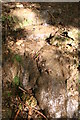
This is a bubbling spring, which runs out from between the layers of Lias rock on the western face of the hill, near the Trent, between Burton- Stather and Alkborough. Keld deriving from O.N for spring and this is certainly an ancient site laying close to Julian's Bower and Roman remains. No traditions are associated with it but it is said to petrify and remains were found in the area, but these were more likely to be fossilised crinoids, a star fish relation.
You may be viewing yesterday's version of this page. To see the most up to date information please register for a free account.
Do not use the above information on other web sites or publications without permission of the contributor.
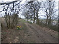
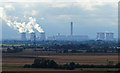
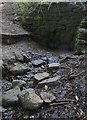
Nearby Images from Geograph Britain and Ireland:
©2005(licence)
©2016(licence)
©2016(licence)
©2016(licence)
©2014(licence)
The above images may not be of the site on this page, they are loaded from Geograph.
Please Submit an Image of this site or go out and take one for us!
Click here to see more info for this site
Nearby sites
Key: Red: member's photo, Blue: 3rd party photo, Yellow: other image, Green: no photo - please go there and take one, Grey: site destroyed
Download sites to:
KML (Google Earth)
GPX (GPS waypoints)
CSV (Garmin/Navman)
CSV (Excel)
To unlock full downloads you need to sign up as a Contributory Member. Otherwise downloads are limited to 50 sites.
Turn off the page maps and other distractions
Nearby sites listing. In the following links * = Image available
1.1km NE 35° Countess Close* Ancient Village or Settlement (SE879216)
1.3km NNE 33° Julian's Bower* Turf Maze (SE880218)
7.2km SSE 155° Dragonby* Natural Stone / Erratic / Other Natural Feature (SE905142)
7.6km ESE 113° Holy Well (Winterton) Holy Well or Sacred Spring (SE944178)
8.8km SSE 168° Crosby Stone Natural Stone / Erratic / Other Natural Feature (SE893121)
11.1km NNE 24° St Helen's Well (South Cave)* Holy Well or Sacred Spring (SE91693096)
12.1km N 11° St. Helen's Well (North Cave)* Holy Well or Sacred Spring (SE894326)
12.4km SSE 148° Gokwell Priory (Broughton) Misc. Earthwork (SE94081028)
12.7km SW 234° Crowle Stone* Early Christian Sculptured Stone (SE772130)
14.5km WNW 302° Ringstone Wood (Howden) Stone Circle (SE748282)
14.9km SE 145° Broughton Cross* Ancient Cross (SE960086)
15.0km NNE 25° St Austin's Stone (High Hunsley)* Natural Stone / Erratic / Other Natural Feature (SE9336034443)
15.7km SSW 203° West Butterwick Henge (SE813062)
17.7km NNE 32° Ling Howe Long Barrow Long Barrow (SE96503580)
18.2km NNE 30° Ella Hill* Round Barrow(s) (SE9606036730)
19.1km SE 134° St. Helen's Well (Wrawby) Holy Well or Sacred Spring (TA0137907720)
19.2km NNE 27° Littlewood Lodge Round Barrow(s) (SE95563801)
19.7km WNW 294° St. Helen's Well (Barmby) Holy Well or Sacred Spring (SE691284)
19.7km NE 35° Middle Howe Round Barrow(s) (SE98283713)
20.6km SSW 206° Holy Well (Lower Burnham)* Holy Well or Sacred Spring (SE78520205)
21.0km ESE 107° Howe Hill (Lincolnshire) Round Barrow(s) (TA07631510)
21.4km NNE 16° Arras Barrow Cemetery* Barrow Cemetery (SE930413)
21.4km SW 232° Hatfield Moor* Ancient Trackway (SE7060407233)
21.5km NNW 337° Lady Well (Seaton Ross) Holy Well or Sacred Spring (SE784403)
21.8km N 6° St Helen's Well (Goodmanham)* Holy Well or Sacred Spring (SE890424)
View more nearby sites and additional images


 We would like to know more about this location. Please feel free to add a brief description and any relevant information in your own language.
 Wir möchten mehr über diese Stätte erfahren. Bitte zögern Sie nicht, eine kurze Beschreibung und relevante Informationen in Deutsch hinzuzufügen.
 Nous aimerions en savoir encore un peu sur les lieux. S'il vous plaît n'hesitez pas à ajouter une courte description et tous les renseignements pertinents dans votre propre langue.
 Quisieramos informarnos un poco más de las lugares. No dude en añadir una breve descripción y otros datos relevantes en su propio idioma.