

<< Our Photo Pages >> Falsgrave Park Circle - Modern Stone Circle etc in England in Yorkshire (North)
Submitted by rogerkread on Tuesday, 05 November 2019 Page Views: 2479
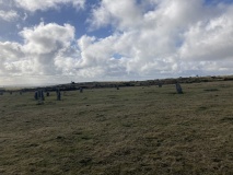
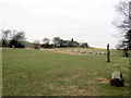
Modern SitesSite Name: Falsgrave Park Circle Alternative Name: Springhill Meadow CircleCountry: England County: Yorkshire (North) Type: Modern Stone Circle etc
Nearest Town: Scarborough
Map Ref: TA028876
Latitude: 54.273724N Longitude: 0.422831W
Condition:
| 5 | Perfect |
| 4 | Almost Perfect |
| 3 | Reasonable but with some damage |
| 2 | Ruined but still recognisable as an ancient site |
| 1 | Pretty much destroyed, possibly visible as crop marks |
| 0 | No data. |
| -1 | Completely destroyed |
| 5 | Superb |
| 4 | Good |
| 3 | Ordinary |
| 2 | Not Good |
| 1 | Awful |
| 0 | No data. |
| 5 | Can be driven to, probably with disabled access |
| 4 | Short walk on a footpath |
| 3 | Requiring a bit more of a walk |
| 2 | A long walk |
| 1 | In the middle of nowhere, a nightmare to find |
| 0 | No data. |
| 5 | co-ordinates taken by GPS or official recorded co-ordinates |
| 4 | co-ordinates scaled from a detailed map |
| 3 | co-ordinates scaled from a bad map |
| 2 | co-ordinates of the nearest village |
| 1 | co-ordinates of the nearest town |
| 0 | no data |
Internal Links:
External Links:
")
Various springs nearby were used to provide water for the Franciscan friars community of Scarborough in the C14th.
You may be viewing yesterday's version of this page. To see the most up to date information please register for a free account.
Do not use the above information on other web sites or publications without permission of the contributor.
Nearby Images from Geograph Britain and Ireland:
©2014(licence)
©2011(licence)
©2013(licence)

©2012(licence)
©2012(licence)
The above images may not be of the site on this page, they are loaded from Geograph.
Please Submit an Image of this site or go out and take one for us!
Click here to see more info for this site
Nearby sites
Key: Red: member's photo, Blue: 3rd party photo, Yellow: other image, Green: no photo - please go there and take one, Grey: site destroyed
Download sites to:
KML (Google Earth)
GPX (GPS waypoints)
CSV (Garmin/Navman)
CSV (Excel)
To unlock full downloads you need to sign up as a Contributory Member. Otherwise downloads are limited to 50 sites.
Turn off the page maps and other distractions
Nearby sites listing. In the following links * = Image available
1.7km ENE 68° Rotunda Museum* Museum (TA0432588255)
2.0km W 271° Seamer Beacon* Round Barrow(s) (TA008876)
2.7km ENE 58° Our Lady's Well (Scarborough)* Holy Well or Sacred Spring (TA051891)
3.0km WSW 248° East Ayton Long Barrow Long Barrow (TA000864)
3.6km S 179° Crossgates Stone (Seamer) Natural Stone / Erratic / Other Natural Feature (TA02948398)
6.4km WNW 300° St Hilda's Holy Well* Holy Well or Sacred Spring (SE9714890729)
6.6km WNW 298° Hackness Church* Ancient Cross (SE96919056)
6.6km S 181° Star Carr* Ancient Village or Settlement (TA0282181013)
7.0km W 268° California Belt Round Barrows Barrow Cemetery (SE95808719)
7.0km W 268° Fox Head Round Barrow* Round Barrow(s) (SE95748723)
7.6km WNW 285° Wykeham Forest Iron Age Square Barrow Cemetery Misc. Earthwork (SE954894)
7.8km W 275° Loft Howe* Round Barrow(s) (SE95018804)
7.8km SE 125° Gristhorpe Tumuli* Round Barrow(s) (TA093832)
8.7km NNW 345° Cloughton Moor Stone Circle (TA0036595947)
9.6km SSE 158° Spell Howe (Folkton) Cairn (TA06577878)
10.1km S 169° Sharp Howes* Barrow Cemetery (TA049777)
10.2km NNW 335° Linglands Farm NW (Hardwood Dale) Cairn (SE9830296749)
10.3km SSE 164° Folkton Round Barrow* Round Barrow(s) (TA059778)
10.4km NNW 334° Linglands Farm Cairnfields (Hardwood Dale) Cairn (SE9804796859)
10.4km NNW 335° Harwood Dale* Stone Circle (SE9824796976)
10.4km S 173° Elf Howe Round Barrow(s) (TA04227725)
11.0km SE 127° Sailors' Well* Holy Well or Sacred Spring (TA117811)
11.4km S 188° Willerby Wold House* Round Barrow(s) (TA015763)
11.5km S 181° Willerby Wold Long Barrow Long Barrow (TA029761)
11.5km SE 130° Filey Roman Signal Station* Ancient Village or Settlement (TA1187080412)
View more nearby sites and additional images


 We would like to know more about this location. Please feel free to add a brief description and any relevant information in your own language.
 Wir möchten mehr über diese Stätte erfahren. Bitte zögern Sie nicht, eine kurze Beschreibung und relevante Informationen in Deutsch hinzuzufügen.
 Nous aimerions en savoir encore un peu sur les lieux. S'il vous plaît n'hesitez pas à ajouter une courte description et tous les renseignements pertinents dans votre propre langue.
 Quisieramos informarnos un poco más de las lugares. No dude en añadir una breve descripción y otros datos relevantes en su propio idioma.