<< Our Photo Pages >> Chanctonbury Hill Cross Dyke - Misc. Earthwork in England in West Sussex
Submitted by SolarMegalith on Tuesday, 28 June 2011 Page Views: 3744
Multi-periodSite Name: Chanctonbury Hill Cross DykeCountry: England
NOTE: This site is 0.162 km away from the location you searched for.
County: West Sussex Type: Misc. Earthwork
Nearest Town: Steyning Nearest Village: Washington
Map Ref: TQ13491205
Latitude: 50.896788N Longitude: 0.387585W
Condition:
| 5 | Perfect |
| 4 | Almost Perfect |
| 3 | Reasonable but with some damage |
| 2 | Ruined but still recognisable as an ancient site |
| 1 | Pretty much destroyed, possibly visible as crop marks |
| 0 | No data. |
| -1 | Completely destroyed |
| 5 | Superb |
| 4 | Good |
| 3 | Ordinary |
| 2 | Not Good |
| 1 | Awful |
| 0 | No data. |
| 5 | Can be driven to, probably with disabled access |
| 4 | Short walk on a footpath |
| 3 | Requiring a bit more of a walk |
| 2 | A long walk |
| 1 | In the middle of nowhere, a nightmare to find |
| 0 | No data. |
| 5 | co-ordinates taken by GPS or official recorded co-ordinates |
| 4 | co-ordinates scaled from a detailed map |
| 3 | co-ordinates scaled from a bad map |
| 2 | co-ordinates of the nearest village |
| 1 | co-ordinates of the nearest town |
| 0 | no data |
Internal Links:
External Links:
I have visited· I would like to visit
SolarMegalith visited on 26th Jun 2011 - their rating: Cond: 3 Amb: 3 Access: 4
Andy B have visited here
")
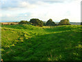
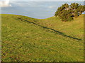
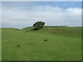
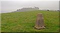
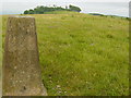
A 106 m long Iron Age cross-dyke is located west from Chanctonbury Ring. It is in good condition, with 0.7m deep ditch and 0.5 m high bank. It is visible from the footpath leading to Chanctonbury Ring from the west.
It is possible that the cross-dyke is contemporary to Chanctonbury Ring (6th-5th century BC).
You may be viewing yesterday's version of this page. To see the most up to date information please register for a free account.
")
")
")
Do not use the above information on other web sites or publications without permission of the contributor.
Nearby Images from Geograph Britain and Ireland:
©2008(licence)
©2011(licence)
©2007(licence)
©2011(licence)
©2005(licence)
The above images may not be of the site on this page, they are loaded from Geograph.
Please Submit an Image of this site or go out and take one for us!
Click here to see more info for this site
Nearby sites
Key: Red: member's photo, Blue: 3rd party photo, Yellow: other image, Green: no photo - please go there and take one, Grey: site destroyed
Download sites to:
KML (Google Earth)
GPX (GPS waypoints)
CSV (Garmin/Navman)
CSV (Excel)
To unlock full downloads you need to sign up as a Contributory Member. Otherwise downloads are limited to 50 sites.
Turn off the page maps and other distractions
Nearby sites listing. In the following links * = Image available
241m E 98° Chanctonbury Hill Bowl Barrow 1* Round Barrow(s) (TQ13731202)
412m E 84° Chanctonbury Ring* Hillfort (TQ139121)
541m E 97° Chanctonbury Hill Saucer Barrows 2-4* Barrow Cemetery (TQ14031200)
760m ESE 110° Chanctonbury Hill Bowl Barrow 5* Round Barrow(s) (TQ14211180)
800m ESE 114° Chanctonbury Hill Bowl Barrow 6* Round Barrow(s) (TQ14231174)
3.5km ESE 121° Steyning Round Hill Cross Dyke Misc. Earthwork (TQ16581031)
3.7km SW 226° Muntham Court Iron Age/Romano British Settlement/Shrine/Well Ancient Village or Settlement (TQ109094)
4.0km W 275° Sullington Hill Cross Dyke* Misc. Earthwork (TQ09451232)
4.0km S 175° Cissbury Ring* Hillfort (TQ13910803)
4.3km SSW 210° Church Hill Flint Mines Ancient Mine, Quarry or other Industry (TQ114083)
4.3km SSW 210° Church Hill Bowl Barrow Round Barrow(s) (TQ11430826)
4.5km E 100° Carved stone in Steyning Church Early Christian Sculptured Stone (TQ1791211392)
4.6km WSW 255° Old Gray's Wood Bowl Barrow Round Barrow(s) (TQ09051078)
4.6km WSW 240° Blackpatch Hill Bowl Barrow* Round Barrow(s) (TQ09540966)
4.7km WSW 249° Harrow Hill Barrows Barrow Cemetery (TQ09141026)
4.7km W 270° Chantry Hill Tumuli* Barrow Cemetery (TQ08731197)
4.8km WSW 247° Cock Hill Barrow* Round Barrow(s) (TQ09101007)
4.8km SW 227° Blackpatch Hill Bowl Barrow Round Barrow(s) (TQ10010872)
5.0km SW 234° Blackpatch Mounds Barrow Cemetery (TQ09500900)
5.0km W 279° Chantry Hill Cross Dyke* Misc. Earthwork (TQ0850512712)
5.1km WSW 244° Cock Hill Settlement Ancient Village or Settlement (TQ08920974)
5.2km SW 233° Blackpatch Flint Mines* Ancient Mine, Quarry or other Industry (TQ094088)
5.2km WSW 237° Blackpatch Settlement Ancient Village or Settlement (TQ09150908)
5.6km W 276° Kithurst Hill Tumuli* Barrow Cemetery (TQ07871254)
5.7km WSW 250° Harrow Hill Flint Mines* Ancient Mine, Quarry or other Industry (TQ082100)
View more nearby sites and additional images


 We would like to know more about this location. Please feel free to add a brief description and any relevant information in your own language.
 Wir möchten mehr über diese Stätte erfahren. Bitte zögern Sie nicht, eine kurze Beschreibung und relevante Informationen in Deutsch hinzuzufügen.
 Nous aimerions en savoir encore un peu sur les lieux. S'il vous plaît n'hesitez pas à ajouter une courte description et tous les renseignements pertinents dans votre propre langue.
 Quisieramos informarnos un poco más de las lugares. No dude en añadir una breve descripción y otros datos relevantes en su propio idioma.