<< Our Photo Pages >> Fletton Cross - Ancient Cross in England in Cambridgeshire
Submitted by Thorgrim on Wednesday, 16 November 2005 Page Views: 5965
Early Medieval (Dark Age)Site Name: Fletton CrossCountry: England
NOTE: This site is 0.797 km away from the location you searched for.
County: Cambridgeshire Type: Ancient Cross
Nearest Town: Peterborough Nearest Village: Fletton
Map Ref: TL198971
Latitude: 52.558559N Longitude: 0.234263W
Condition:
| 5 | Perfect |
| 4 | Almost Perfect |
| 3 | Reasonable but with some damage |
| 2 | Ruined but still recognisable as an ancient site |
| 1 | Pretty much destroyed, possibly visible as crop marks |
| 0 | No data. |
| -1 | Completely destroyed |
| 5 | Superb |
| 4 | Good |
| 3 | Ordinary |
| 2 | Not Good |
| 1 | Awful |
| 0 | No data. |
| 5 | Can be driven to, probably with disabled access |
| 4 | Short walk on a footpath |
| 3 | Requiring a bit more of a walk |
| 2 | A long walk |
| 1 | In the middle of nowhere, a nightmare to find |
| 0 | No data. |
| 5 | co-ordinates taken by GPS or official recorded co-ordinates |
| 4 | co-ordinates scaled from a detailed map |
| 3 | co-ordinates scaled from a bad map |
| 2 | co-ordinates of the nearest village |
| 1 | co-ordinates of the nearest town |
| 0 | no data |
Internal Links:
External Links:
")
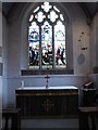
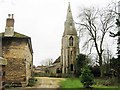
Inscribed cross shaft at the west end of Fletton church
You may be viewing yesterday's version of this page. To see the most up to date information please register for a free account.
")
")
Do not use the above information on other web sites or publications without permission of the contributor.
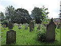
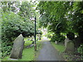
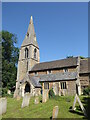
Nearby Images from Geograph Britain and Ireland:
©2016(licence)
©2016(licence)
©2016(licence)
©2022(licence)
©2013(licence)
The above images may not be of the site on this page, they are loaded from Geograph.
Please Submit an Image of this site or go out and take one for us!
Click here to see more info for this site
Nearby sites
Key: Red: member's photo, Blue: 3rd party photo, Yellow: other image, Green: no photo - please go there and take one, Grey: site destroyed
Download sites to:
KML (Google Earth)
GPX (GPS waypoints)
CSV (Garmin/Navman)
CSV (Excel)
To unlock full downloads you need to sign up as a Contributory Member. Otherwise downloads are limited to 50 sites.
Turn off the page maps and other distractions
Nearby sites listing. In the following links * = Image available
1.6km NNW 332° Peterborough Stone* Standing Stone (Menhir) (TL190985)
1.6km NNW 347° Hedda Stone* Early Christian Sculptured Stone (TL194987)
1.7km NNW 329° Peterborough Museum* Museum (TL189985)
3.2km WNW 291° St. Cloud's Well (Longthorpe)* Holy Well or Sacred Spring (TL16789815)
3.4km ENE 60° Flag Fen Visitors Centre* Museum (TL227989)
3.9km E 84° Must Farm* Ancient Village or Settlement (TL237976)
3.9km SW 221° Stone Circle, James' Pond* Modern Stone Circle etc (TL17309405)
5.8km NE 37° Oliver Cromwell's Hill (Eye) Cairn (TF232018)
6.0km WNW 284° Robin Hood and Little John* Standing Stones (TL1395098389)
8.5km W 275° Water Newton Mill Bowl Barrow* Round Barrow(s) (TL11269770)
9.2km NE 45° Pode Hole Farm Round Barrow(s) (TF262037)
10.2km N 357° Borough Fen* Hillfort (TF19080727)
10.8km WNW 290° Upton Causewayed Enclosure Causewayed Enclosure (TF095005)
11.3km NW 319° St Botolph (Helpston) Ancient Cross (TF12200552)
12.1km NNW 330° Etton Causewayed Enclosure* Causewayed Enclosure (TF135075)
12.2km NNW 329° Maxey Cursus Cursus (TF133074)
12.2km NNW 341° Northborough Causewayed Enclosure Causewayed Enclosure (TF155085)
12.8km NNW 327° Maxey Henge Henge (TF12600772)
12.9km NNW 327° Maxey Pit Circle A Timber Circle (TF125077)
12.9km NNW 327° Maxey Pit Circle A Timber Circle (TF125078)
13.7km WNW 287° Thornhaugh Henge Henge (TF066008)
13.7km NW 315° Bainton Cursus Cursus (TF099066)
13.7km NW 326° Maxey Cursus Cursus (TF11800830)
13.7km NW 326° Maxey Cursus Cursus (TF118083)
14.3km NW 305° St John the Baptist (Barnack)* Ancient Cross (TF07930505)
View more nearby sites and additional images


 We would like to know more about this location. Please feel free to add a brief description and any relevant information in your own language.
 Wir möchten mehr über diese Stätte erfahren. Bitte zögern Sie nicht, eine kurze Beschreibung und relevante Informationen in Deutsch hinzuzufügen.
 Nous aimerions en savoir encore un peu sur les lieux. S'il vous plaît n'hesitez pas à ajouter une courte description et tous les renseignements pertinents dans votre propre langue.
 Quisieramos informarnos un poco más de las lugares. No dude en añadir una breve descripción y otros datos relevantes en su propio idioma.