<< Our Photo Pages >> Welwyn Roman Baths - Ancient Village or Settlement in England in Hertfordshire
Submitted by JoAtherton on Wednesday, 06 September 2023 Page Views: 766
Roman, Greek and ClassicalSite Name: Welwyn Roman BathsCountry: England
NOTE: This site is 3.021 km away from the location you searched for.
County: Hertfordshire Type: Ancient Village or Settlement
Map Ref: TL23451602
Latitude: 51.829164N Longitude: 0.209962W
Condition:
| 5 | Perfect |
| 4 | Almost Perfect |
| 3 | Reasonable but with some damage |
| 2 | Ruined but still recognisable as an ancient site |
| 1 | Pretty much destroyed, possibly visible as crop marks |
| 0 | No data. |
| -1 | Completely destroyed |
| 5 | Superb |
| 4 | Good |
| 3 | Ordinary |
| 2 | Not Good |
| 1 | Awful |
| 0 | No data. |
| 5 | Can be driven to, probably with disabled access |
| 4 | Short walk on a footpath |
| 3 | Requiring a bit more of a walk |
| 2 | A long walk |
| 1 | In the middle of nowhere, a nightmare to find |
| 0 | No data. |
| 5 | co-ordinates taken by GPS or official recorded co-ordinates |
| 4 | co-ordinates scaled from a detailed map |
| 3 | co-ordinates scaled from a bad map |
| 2 | co-ordinates of the nearest village |
| 1 | co-ordinates of the nearest town |
| 0 | no data |
Internal Links:
External Links:
I have visited· I would like to visit
Jimi103ci would like to visit
")
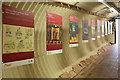
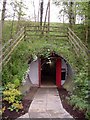
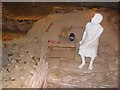
I found the location just as interesting as the site actually. A sign said that local archaeologists battled 'red tape and disinterest' to have a vault constructed and protect the site. I'm glad they did as it's totally unique.
Open every Saturday 10am - 4pm (last admission 3.30pm).
Sometimes also open Hertfordshire School Holidays - check the web site at
https://www.millgreenmuseum.co.uk/roman-baths/
Note: Tours of Welwyn Roman Baths, Saturday 9th September 2023
You may be viewing yesterday's version of this page. To see the most up to date information please register for a free account.
")
Do not use the above information on other web sites or publications without permission of the contributor.
Nearby Images from Geograph Britain and Ireland:
©2013(licence)
©2009(licence)
©2013(licence)
©2006(licence)
©2009(licence)
The above images may not be of the site on this page, they are loaded from Geograph.
Please Submit an Image of this site or go out and take one for us!
Click here to see more info for this site
Nearby sites
Key: Red: member's photo, Blue: 3rd party photo, Yellow: other image, Green: no photo - please go there and take one, Grey: site destroyed
Download sites to:
KML (Google Earth)
GPX (GPS waypoints)
CSV (Garmin/Navman)
CSV (Excel)
To unlock full downloads you need to sign up as a Contributory Member. Otherwise downloads are limited to 50 sites.
Turn off the page maps and other distractions
Nearby sites listing. In the following links * = Image available
393m WNW 299° Welwyn Puddingstone* Natural Stone / Erratic / Other Natural Feature (TL231162)
2.6km ENE 69° Perry's Grove Boundary Ditch* Misc. Earthwork (TL25851700)
5.5km WSW 242° Devil's Dyke (Hertfordshire)* Ancient Village or Settlement (TL186133)
6.3km S 176° Mill Green Museum Museum (TL240097)
7.6km N 4° Six Hills* Round Barrow(s) (TL23742365)
9.7km SSE 164° Wildhill Puddingstone Natural Stone / Erratic / Other Natural Feature (TL263067)
10.4km SW 231° Beech Bottom Dyke* Ancient Village or Settlement (TL155093)
11.0km SSW 206° Tyttenhanger Puddingstones Natural Stone / Erratic / Other Natural Feature (TL189060)
11.7km ESE 103° Chadwell Spring* Holy Well or Sacred Spring (TL349136)
12.0km N 353° Priory Well (Hertfordshire)* Holy Well or Sacred Spring (TL217279)
12.8km SW 230° St Albans Puddingstones* Natural Stone / Erratic / Other Natural Feature (TL139075)
12.8km SW 225° Holy Well (St. Albans)* Holy Well or Sacred Spring (TL14640670)
13.2km SW 231° Verulamium Puddingstone Natural Stone / Erratic / Other Natural Feature (TL134074)
13.3km SSE 165° Griffin's Hole* Holy Well or Sacred Spring (TL2720403249)
13.5km ENE 75° Lunardi Stone* Natural Stone / Erratic / Other Natural Feature (TL364198)
13.5km WSW 237° Devil's Ditch (Hertfordshire) Ancient Village or Settlement (TL123084)
14.2km ESE 106° Emma's Well* Holy Well or Sacred Spring (TL372125)
14.2km NNW 340° North Herts Museum* Museum (TL18342926)
14.7km WSW 253° The Aubreys* Hillfort (TL095113)
14.8km S 176° Potters Bar Museum Museum (TL2494101262)
15.4km NNE 26° Cumberlow Green hoard Ancient Mine, Quarry or other Industry (TL3030)
15.7km NNE 34° Cottered Stones* Natural Stone / Erratic / Other Natural Feature (TL318293)
16.0km SW 229° Potterscrouch Puddingstones Natural Stone / Erratic / Other Natural Feature (TL116052)
16.0km N 9° Weston Hill Henge* Henge (TL256319)
16.7km SE 140° Flamstead Puddingstone Marker Stone (TL346035)
View more nearby sites and additional images


 We would like to know more about this location. Please feel free to add a brief description and any relevant information in your own language.
 Wir möchten mehr über diese Stätte erfahren. Bitte zögern Sie nicht, eine kurze Beschreibung und relevante Informationen in Deutsch hinzuzufügen.
 Nous aimerions en savoir encore un peu sur les lieux. S'il vous plaît n'hesitez pas à ajouter une courte description et tous les renseignements pertinents dans votre propre langue.
 Quisieramos informarnos un poco más de las lugares. No dude en añadir una breve descripción y otros datos relevantes en su propio idioma.