<< Text Pages >> Mill Green Museum - Museum in England in Hertfordshire
Submitted by vicky on Saturday, 30 November 2002 Page Views: 4787
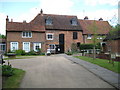
MuseumsSite Name: Mill Green MuseumCountry: England County: Hertfordshire Type: Museum
Nearest Town: Hatfield
Map Ref: TL240097 Landranger Map Number: 166
Latitude: 51.772247N Longitude: 0.204243W
Condition:
| 5 | Perfect |
| 4 | Almost Perfect |
| 3 | Reasonable but with some damage |
| 2 | Ruined but still recognisable as an ancient site |
| 1 | Pretty much destroyed, possibly visible as crop marks |
| 0 | No data. |
| -1 | Completely destroyed |
| 5 | Superb |
| 4 | Good |
| 3 | Ordinary |
| 2 | Not Good |
| 1 | Awful |
| 0 | No data. |
| 5 | Can be driven to, probably with disabled access |
| 4 | Short walk on a footpath |
| 3 | Requiring a bit more of a walk |
| 2 | A long walk |
| 1 | In the middle of nowhere, a nightmare to find |
| 0 | No data. |
| 5 | co-ordinates taken by GPS or official recorded co-ordinates |
| 4 | co-ordinates scaled from a detailed map |
| 3 | co-ordinates scaled from a bad map |
| 2 | co-ordinates of the nearest village |
| 1 | co-ordinates of the nearest town |
| 0 | no data |
Be the first person to rate this site - see the 'Contribute!' box in the right hand menu.
Internal Links:
External Links:
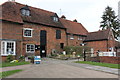
Museum in Hertfordshire
Two permanent galleries displaying local artefacts from prehistory to the present day.
Address: Mill Green , AL9 5PD
Phone: 01707 271362
Opening Hours: Tuesday - Friday 10.00am - 5.00pm , Saturdays, Sundays & Bank Holidays 2.00pm - 5.00pm
Admission: Free
Visit their web site
You may be viewing yesterday's version of this page. To see the most up to date information please register for a free account.
Do not use the above information on other web sites or publications without permission of the contributor.
Nearby Images from Geograph Britain and Ireland:
©2007(licence)
©2013(licence)
©2009(licence)
©2013(licence)
©2009(licence)
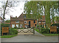
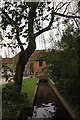
The above images may not be of the site on this page, they are loaded from Geograph.
Please Submit an Image of this site or go out and take one for us!
Click here to see more info for this site
Nearby sites
Key: Red: member's photo, Blue: 3rd party photo, Yellow: other image, Green: no photo - please go there and take one, Grey: site destroyed
Download sites to:
KML (Google Earth)
GPX (GPS waypoints)
CSV (Garmin/Navman)
CSV (Excel)
To unlock full downloads you need to sign up as a Contributory Member. Otherwise downloads are limited to 50 sites.
Turn off the page maps and other distractions
Nearby sites listing. In the following links * = Image available
3.8km SE 144° Wildhill Puddingstone Natural Stone / Erratic / Other Natural Feature (TL263067)
6.3km SW 235° Tyttenhanger Puddingstones Natural Stone / Erratic / Other Natural Feature (TL189060)
6.3km N 356° Welwyn Roman Baths* Ancient Village or Settlement (TL23451602)
6.5km NW 305° Devil's Dyke (Hertfordshire)* Ancient Village or Settlement (TL186133)
6.6km N 354° Welwyn Puddingstone* Natural Stone / Erratic / Other Natural Feature (TL231162)
7.2km SSE 155° Griffin's Hole* Holy Well or Sacred Spring (TL2720403249)
7.5km NNE 16° Perry's Grove Boundary Ditch* Misc. Earthwork (TL25851700)
8.5km W 269° Beech Bottom Dyke* Ancient Village or Settlement (TL155093)
8.5km S 175° Potters Bar Museum Museum (TL2494101262)
9.8km WSW 254° Holy Well (St. Albans)* Holy Well or Sacred Spring (TL14640670)
10.3km W 259° St Albans Puddingstones* Natural Stone / Erratic / Other Natural Feature (TL139075)
10.8km W 259° Verulamium Puddingstone Natural Stone / Erratic / Other Natural Feature (TL134074)
11.5km ENE 72° Chadwell Spring* Holy Well or Sacred Spring (TL349136)
11.7km W 265° Devil's Ditch (Hertfordshire) Ancient Village or Settlement (TL123084)
12.3km ESE 122° Flamstead Puddingstone Marker Stone (TL346035)
13.2km WSW 251° Potterscrouch Puddingstones Natural Stone / Erratic / Other Natural Feature (TL116052)
13.5km E 79° Emma's Well* Holy Well or Sacred Spring (TL372125)
13.9km N 0° Six Hills* Round Barrow(s) (TL23742365)
14.5km W 278° The Aubreys* Hillfort (TL095113)
15.9km ESE 117° Monkham Puddingstone Marker Stone (TL384029)
16.0km NE 52° Lunardi Stone* Natural Stone / Erratic / Other Natural Feature (TL364198)
16.1km ESE 116° Holyfield Puddingstone* Marker Stone (TL38670303)
16.1km WSW 253° Bedmond Puddingstone Natural Stone / Erratic / Other Natural Feature (TL087045)
16.2km SSE 152° Bush Hill Hillfort (TQ321956)
17.0km ESE 112° Galley Hill Puddingstone Marker Stone (TL400038)
View more nearby sites and additional images


 We would like to know more about this location. Please feel free to add a brief description and any relevant information in your own language.
 Wir möchten mehr über diese Stätte erfahren. Bitte zögern Sie nicht, eine kurze Beschreibung und relevante Informationen in Deutsch hinzuzufügen.
 Nous aimerions en savoir encore un peu sur les lieux. S'il vous plaît n'hesitez pas à ajouter une courte description et tous les renseignements pertinents dans votre propre langue.
 Quisieramos informarnos un poco más de las lugares. No dude en añadir una breve descripción y otros datos relevantes en su propio idioma.