<< Text Pages >> Tiya Stelae - Standing Stones in Ethiopia
Submitted by AlexHunger on Sunday, 23 July 2006 Page Views: 15604
Neolithic and Bronze AgeSite Name: Tiya StelaeCountry: Ethiopia
NOTE: This site is 65.202 km away from the location you searched for.
Type: Standing Stones
Nearest Town: Addis Ababa
Latitude: 8.434920N Longitude: 38.612110E
Condition:
| 5 | Perfect |
| 4 | Almost Perfect |
| 3 | Reasonable but with some damage |
| 2 | Ruined but still recognisable as an ancient site |
| 1 | Pretty much destroyed, possibly visible as crop marks |
| 0 | No data. |
| -1 | Completely destroyed |
| 5 | Superb |
| 4 | Good |
| 3 | Ordinary |
| 2 | Not Good |
| 1 | Awful |
| 0 | No data. |
| 5 | Can be driven to, probably with disabled access |
| 4 | Short walk on a footpath |
| 3 | Requiring a bit more of a walk |
| 2 | A long walk |
| 1 | In the middle of nowhere, a nightmare to find |
| 0 | No data. |
| 5 | co-ordinates taken by GPS or official recorded co-ordinates |
| 4 | co-ordinates scaled from a detailed map |
| 3 | co-ordinates scaled from a bad map |
| 2 | co-ordinates of the nearest village |
| 1 | co-ordinates of the nearest town |
| 0 | no data |
Be the first person to rate this site - see the 'Contribute!' box in the right hand menu.
Internal Links:
External Links:
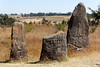
Standing Stones in Ethiopia
The Tiya site is among the most important of roughly 160 archaeological sites discovered in the Soddo region in Ethiopia. The site contains 36 monuments, including 32 carved stelae covered with symbols, most of which are difficult to decipher.
You may be viewing yesterday's version of this page. To see the most up to date information please register for a free account.
Do not use the above information on other web sites or publications without permission of the contributor.
Nearby Images from Flickr


The above images may not be of the site on this page, but were taken nearby. They are loaded from Flickr so please click on them for image credits.
Click here to see more info for this site
Nearby sites
Click here to view sites on an interactive map of the areaKey: Red: member's photo, Blue: 3rd party photo, Yellow: other image, Green: no photo - please go there and take one, Grey: site destroyed
Download sites to:
KML (Google Earth)
GPX (GPS waypoints)
CSV (Garmin/Navman)
CSV (Excel)
To unlock full downloads you need to sign up as a Contributory Member. Otherwise downloads are limited to 50 sites.
Turn off the page maps and other distractions
Nearby sites listing. In the following links * = Image available
241.4km S 190° Tutu Fela* Sculptured Stone
447.1km NNW 341° Gorgora Rock Shelter* Cave or Rock Shelter
618.2km ENE 77° Laas Gaal* Cave or Rock Shelter
633.4km N 1° Aksum* Ancient Village or Settlement
638.1km SSW 209° Kalokol stone pillars* Standing Stones
651.8km N 4° Yeha* Ancient Village or Settlement
674.3km SSW 205° Lothagam Pillar site Standing Stones
726.7km SSW 202° Lokori Stone Pillars Standing Stone (Menhir)
763.0km SSW 202° Namoratunga Rock Engravings Rock Art
780.7km NE 43° Al Muhandid stone rows Stone Row / Alignment
797.4km NE 38° Al Fazah standing stone Standing Stones
801.6km NE 37° al-Tihamah Standing Stones
828.7km ENE 74° Dhambalin* Rock Art
855.8km NE 52° Sabr Ancient Village or Settlement
876.1km NE 45° Osaibah archaeological site Rock Cut Tomb
919.5km S 188° Lewa Rock Gongs Rock Art
934.3km SSW 207° Orchard Cave, Kenya* Cave or Rock Shelter
936.5km SW 215° Nyero Rockpaintings Rock Art
948.4km NE 34° al-Mahwit tombs Rock Cut Tomb
951.0km SSW 212° Kakoro Rock art Rock Art
1008.1km SSW 196° Hyrax Hill Ancient Village or Settlement
1037.3km NW 321° Sudan National Museum Museum
1055.7km NE 42° Mahram Bilqis* Ancient Temple
1057.6km NE 42° Great Dam of Marib* Ancient Mine, Quarry or other Industry
1058.9km NE 43° Sabaean Temple of the Moon* Ancient Temple
View more nearby sites and additional images


 We would like to know more about this location. Please feel free to add a brief description and any relevant information in your own language.
 Wir möchten mehr über diese Stätte erfahren. Bitte zögern Sie nicht, eine kurze Beschreibung und relevante Informationen in Deutsch hinzuzufügen.
 Nous aimerions en savoir encore un peu sur les lieux. S'il vous plaît n'hesitez pas à ajouter une courte description et tous les renseignements pertinents dans votre propre langue.
 Quisieramos informarnos un poco más de las lugares. No dude en añadir una breve descripción y otros datos relevantes en su propio idioma.