<< Our Photo Pages >> The Devil's Nest (Pirunpesä) - Natural Stone / Erratic / Other Natural Feature in Finland
Submitted by Anne T on Wednesday, 01 October 2014 Page Views: 7455
Natural PlacesSite Name: The Devil's Nest (Pirunpesä) Alternative Name: Giant Kettle Pirunpesä, Giant Kettle Pirunpesä, Devil's Nest (Pirunpesa)Country: Finland Type: Natural Stone / Erratic / Other Natural Feature
Nearest Town: Pirunpesä Nearest Village: Yli-valli
Latitude: 62.399056N Longitude: 22.895472E
Condition:
| 5 | Perfect |
| 4 | Almost Perfect |
| 3 | Reasonable but with some damage |
| 2 | Ruined but still recognisable as an ancient site |
| 1 | Pretty much destroyed, possibly visible as crop marks |
| 0 | No data. |
| -1 | Completely destroyed |
| 5 | Superb |
| 4 | Good |
| 3 | Ordinary |
| 2 | Not Good |
| 1 | Awful |
| 0 | No data. |
| 5 | Can be driven to, probably with disabled access |
| 4 | Short walk on a footpath |
| 3 | Requiring a bit more of a walk |
| 2 | A long walk |
| 1 | In the middle of nowhere, a nightmare to find |
| 0 | No data. |
| 5 | co-ordinates taken by GPS or official recorded co-ordinates |
| 4 | co-ordinates scaled from a detailed map |
| 3 | co-ordinates scaled from a bad map |
| 2 | co-ordinates of the nearest village |
| 1 | co-ordinates of the nearest town |
| 0 | no data |
Internal Links:
External Links:
 (PID:125293)")
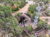
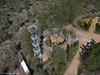
Similar to the Käpylä Hiidenkirnu, the Devil's Kettle, near Helsinki, this natural feature has been created by glacial action over many hundreds of thousands of years – it has repeatedly been hollowed out, filled with sediment then hollowed out again by the ice.
Measuring 14 metres wide by 23 metres deep, the Devil’s Nest is Europe’s largest eroded cavity, although there is currently debate as to whether or not this pit might be a natural outlet for water or gas rather than just the result of cycles of glacial erosion (or maybe a combination of all these processes).
Located in the village Yli-valli in the municipality of Jalasjärvi in Southern Ostrobothnia, further information can be found at Wikipedia and photos on Flickr.
There are no records of any archaeological finds during excavations. Many thanks to Martti Lahti who provided the initial information to create this page - see further comments below for the folklore attached to the creation of the name 'The Devil's Nest'.
Note: Have you visited this site? Have you any information or photographs to add?
You may be viewing yesterday's version of this page. To see the most up to date information please register for a free account.
 (PID:125292)")
 (PID:125291)")
Do not use the above information on other web sites or publications without permission of the contributor.
Nearby Images from Flickr

The above images may not be of the site on this page, but were taken nearby. They are loaded from Flickr so please click on them for image credits.
Click here to see more info for this site
Nearby sites
Click here to view sites on an interactive map of the areaKey: Red: member's photo, Blue: 3rd party photo, Yellow: other image, Green: no photo - please go there and take one, Grey: site destroyed
Download sites to:
KML (Google Earth)
GPX (GPS waypoints)
CSV (Garmin/Navman)
CSV (Excel)
To unlock full downloads you need to sign up as a Contributory Member. Otherwise downloads are limited to 50 sites.
Turn off the page maps and other distractions
Nearby sites listing. In the following links * = Image available
47.4km NW 317° Hiivanaasenkivi* Artificial Mound
47.4km NW 317° Hiivanaanen* Artificial Mound
64.1km W 261° Susiluola* Cave or Rock Shelter
65.9km NNW 338° Levänluhta Holy Well or Sacred Spring
80.2km NNW 332° Tervajoki* Barrow Cemetery
82.8km NNW 344° Höjsalträsk Giant's Church Stone Fort or Dun
82.8km NNW 331° Vahakyro* Barrow Cemetery
87.2km NNW 345° Tavoma 1 Giant's Church Stone Fort or Dun
94.7km N 3° Korkeamäki Giant's Church* Stone Fort or Dun
95.3km SW 231° Merikarvia King's grave* Cairn
115.4km N 3° Kejsmolandsbacken Giant's Church Stone Fort or Dun
120.0km N 5° Purmo-Jäknabacken Giant's Church Stone Fort or Dun
121.6km N 10° Storbacken Giant's Church Stone Fort or Dun
124.3km N 6° Esse-Svedjebacken Giant's Church Stone Fort or Dun
124.4km N 9° Esse-Hembacken Giant's Church Stone Fort or Dun
127.5km N 8° Esse-Tallbackharju Giant's Church Stone Fort or Dun
128.1km N 8° Esse-Tallbackharju N Giant's Church Stone Fort or Dun
130.0km SSW 193° Kokemaki* Barrow Cemetery
130.9km SSE 155° Järvensuo I* Ancient Village or Settlement
134.0km N 11° Terjärv-Snårbacken Giant's Church Stone Fort or Dun
140.6km N 8° Högryggen Giant's Church Stone Fort or Dun
144.6km N 10° Nedervetil Kåtabacken Giant's Church Stone Fort or Dun
146.7km SSE 155° Rapola* Hillfort
152.1km NNE 13° Tressunharju Giant's Church Stone Fort or Dun
152.7km NNE 14° Kiimanevan Hautakangas Giant's Church Stone Fort or Dun
View more nearby sites and additional images


 We would like to know more about this location. Please feel free to add a brief description and any relevant information in your own language.
 Wir möchten mehr über diese Stätte erfahren. Bitte zögern Sie nicht, eine kurze Beschreibung und relevante Informationen in Deutsch hinzuzufügen.
 Nous aimerions en savoir encore un peu sur les lieux. S'il vous plaît n'hesitez pas à ajouter une courte description et tous les renseignements pertinents dans votre propre langue.
 Quisieramos informarnos un poco más de las lugares. No dude en añadir una breve descripción y otros datos relevantes en su propio idioma.