<< Our Photo Pages >> Carn na Sean-chreige - Hillfort in Scotland in Highlands
Submitted by uisdean on Monday, 30 June 2008 Page Views: 5462
Iron Age and Later PrehistorySite Name: Carn na Sean-chreigeCountry: Scotland
NOTE: This site is 3.538 km away from the location you searched for.
County: Highlands Type: Hillfort
Nearest Town: Kyle of Lochalsh Nearest Village: Plocton
Map Ref: NG81893146
Latitude: 57.321379N Longitude: 5.624235W
Condition:
| 5 | Perfect |
| 4 | Almost Perfect |
| 3 | Reasonable but with some damage |
| 2 | Ruined but still recognisable as an ancient site |
| 1 | Pretty much destroyed, possibly visible as crop marks |
| 0 | No data. |
| -1 | Completely destroyed |
| 5 | Superb |
| 4 | Good |
| 3 | Ordinary |
| 2 | Not Good |
| 1 | Awful |
| 0 | No data. |
| 5 | Can be driven to, probably with disabled access |
| 4 | Short walk on a footpath |
| 3 | Requiring a bit more of a walk |
| 2 | A long walk |
| 1 | In the middle of nowhere, a nightmare to find |
| 0 | No data. |
| 5 | co-ordinates taken by GPS or official recorded co-ordinates |
| 4 | co-ordinates scaled from a detailed map |
| 3 | co-ordinates scaled from a bad map |
| 2 | co-ordinates of the nearest village |
| 1 | co-ordinates of the nearest town |
| 0 | no data |
Internal Links:
External Links:
")
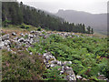
On a knoll known as Carn na Sean-chreige are the remains of a rectangular fort. The walls have been stripped of stone almost to ground level. The fort is oriented roughly NW/SE and is some 30m by 28m. Traces of galleries remain within the walls; and one lintel is still visible near the NW corner. The whole site was planted with trees in the 1960s; these have now been harvested but both the interior and the surrounding ground is rough with tree stumps and coarse vegetation.
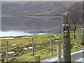
The knoll on which the fort was built falls away steeply to the SW; here nothing remains of the wall but scattered boulders. The site commands a fine view of Loch Achaid na h-Inich, on which the remains of a crannog are to be found.
You may be viewing yesterday's version of this page. To see the most up to date information please register for a free account.
")
")
")
Do not use the above information on other web sites or publications without permission of the contributor.
Nearby Images from Geograph Britain and Ireland:

©2014(licence)
©2014(licence)

©2023(licence)
©2010(licence)

©2014(licence)
The above images may not be of the site on this page, they are loaded from Geograph.
Please Submit an Image of this site or go out and take one for us!
Click here to see more info for this site
Nearby sites
Key: Red: member's photo, Blue: 3rd party photo, Yellow: other image, Green: no photo - please go there and take one, Grey: site destroyed
Download sites to:
KML (Google Earth)
GPX (GPS waypoints)
CSV (Garmin/Navman)
CSV (Excel)
To unlock full downloads you need to sign up as a Contributory Member. Otherwise downloads are limited to 50 sites.
Turn off the page maps and other distractions
Nearby sites listing. In the following links * = Image available
880m SW 232° Loch Achaidh na h-Inich* Crannog (NG81173095)
3.8km ESE 120° Gleann Udalain Cairn Cairn (NG85092942)
3.9km SSE 165° Dun Kirkton Stone Fort or Dun (NG82722768)
4.2km SSE 160° Angels' Hill, Kirkton* Hillfort (NG83142745)
4.2km SSE 160° Lochalsh* Stone Circle (NG831274)
4.9km SE 137° Dun Gleann Udalain Stone Fort or Dun (NG85062773)
7.9km SE 138° Dun Totaig (Loch Duich) Broch or Nuraghe (NG868253)
8.0km SE 140° Caisteal Grugaig* Broch or Nuraghe (NG86692508)
8.2km SE 135° Totaig Cup Markings* Rock Art (NG87432536)
8.7km ESE 111° Bard's Castle* Hillfort (NG89822790)
9.1km N 8° Lag An Duin Broch or Nuraghe (NG83624044)
9.2km WSW 242° Sligeanach Kildonan Stone Row / Alignment (NG735275)
10.4km S 184° Bernera Farm* Rock Art (NG80552110)
10.5km SE 128° Carr Brae* Rock Art (NG89782451)
10.6km SE 140° Torran a'Bharraich* Hillfort (NG88312296)
10.7km S 176° Am Baghan Galldair* Stone Fort or Dun (NG82162075)
11.0km SE 138° Allt an Inbhir Souterrain* Souterrain (Fogou, Earth House) (NG88882296)
11.5km SSE 162° Serpent Mound (Scallasaig) Cairn (NG8484020288)
11.7km S 174° An Dun (Barnhill)* Stone Fort or Dun (NG82441972)
12.8km WNW 300° Toscaig (Applecross) Standing Stones (NG712385)
12.8km E 98° Camas Luinie* Rock Art (NG94492909)
13.8km E 99° Faddoch* Rock Art (NG95452863)
14.2km S 172° Corrary Prehistoric Site* Cairn (NG83121725)
14.3km S 173° Dun Telve* Broch or Nuraghe (NG829172)
14.3km S 171° Dun Troddan* Broch or Nuraghe (NG834172)
View more nearby sites and additional images


 We would like to know more about this location. Please feel free to add a brief description and any relevant information in your own language.
 Wir möchten mehr über diese Stätte erfahren. Bitte zögern Sie nicht, eine kurze Beschreibung und relevante Informationen in Deutsch hinzuzufügen.
 Nous aimerions en savoir encore un peu sur les lieux. S'il vous plaît n'hesitez pas à ajouter une courte description et tous les renseignements pertinents dans votre propre langue.
 Quisieramos informarnos un poco más de las lugares. No dude en añadir una breve descripción y otros datos relevantes en su propio idioma.