<< Our Photo Pages >> Moleigh - Cairn in Scotland in Argyll
Submitted by caradoc68 on Thursday, 25 March 2004 Page Views: 4794
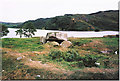
Neolithic and Bronze AgeSite Name: Moleigh Alternative Name: Kilmore 4Country: Scotland
NOTE: This site is 1.389 km away from the location you searched for.
County: Argyll Type: Cairn
Nearest Town: Oban Nearest Village: Kilmore
Map Ref: NM88082631 Landranger Map Number: 49
Latitude: 56.381428N Longitude: 5.434073W
Condition:
| 5 | Perfect |
| 4 | Almost Perfect |
| 3 | Reasonable but with some damage |
| 2 | Ruined but still recognisable as an ancient site |
| 1 | Pretty much destroyed, possibly visible as crop marks |
| 0 | No data. |
| -1 | Completely destroyed |
| 5 | Superb |
| 4 | Good |
| 3 | Ordinary |
| 2 | Not Good |
| 1 | Awful |
| 0 | No data. |
| 5 | Can be driven to, probably with disabled access |
| 4 | Short walk on a footpath |
| 3 | Requiring a bit more of a walk |
| 2 | A long walk |
| 1 | In the middle of nowhere, a nightmare to find |
| 0 | No data. |
| 5 | co-ordinates taken by GPS or official recorded co-ordinates |
| 4 | co-ordinates scaled from a detailed map |
| 3 | co-ordinates scaled from a bad map |
| 2 | co-ordinates of the nearest village |
| 1 | co-ordinates of the nearest town |
| 0 | no data |
Internal Links:
External Links:
")
This is one of the best preserved of the remarkable concentration of cairns in the valley between the SW end of Loch Neill and the head of Loch Feochan. It measures about 21.3 metres in diameter and, although reduced by stone-robbing, it still stands to a height of 1.4 metres. Several granite kerb-stones survive round the perimeter, the largest standing to a height of 0.7
You may be viewing yesterday's version of this page. To see the most up to date information please register for a free account.
")
Do not use the above information on other web sites or publications without permission of the contributor.
Nearby Images from Geograph Britain and Ireland:
©2012(licence)
©2011(licence)
©2015(licence)
©2015(licence)
©2008(licence)
The above images may not be of the site on this page, they are loaded from Geograph.
Please Submit an Image of this site or go out and take one for us!
Click here to see more info for this site
Nearby sites
Key: Red: member's photo, Blue: 3rd party photo, Yellow: other image, Green: no photo - please go there and take one, Grey: site destroyed
Download sites to:
KML (Google Earth)
GPX (GPS waypoints)
CSV (Garmin/Navman)
CSV (Excel)
To unlock full downloads you need to sign up as a Contributory Member. Otherwise downloads are limited to 50 sites.
Turn off the page maps and other distractions
Nearby sites listing. In the following links * = Image available
220m S 175° Possible cairn at Kilmore* Cairn (NM88092609)
291m S 171° Cleigh* Misc. Earthwork (NM88112602)
310m S 173° Dalinaneun Farm Cairn 2* Cairn (NM881260)
409m NNW 345° Dalineun* Chambered Tomb (NM8799326710)
417m NE 39° Barnacarry* Crannog (NM88362662)
496m NNW 348° Dalinaneun Farm Cairn 3 Cairn (NM880268)
496m NNW 348° Serpent Mound - Loch Nell* Artificial Mound (NM880268)
983m S 172° Kilmore Cairn* Cairn (NM88172533)
990m S 180° Cnoc Buidhe* Cairn (NM88032532)
1.0km N 357° Killiechonich* Rock Art (NM88082736)
1.2km SSE 167° Kilmore House* Cairn (NM88292515)
2.5km NNE 29° Skull Shaped Stone - Loch Nell* Natural Stone / Erratic / Other Natural Feature (NM8939628383)
2.5km NE 42° Rubha Na Moine* Crannog (NM89812807)
2.7km WNW 289° Ariogan Cairn* Cairn (NM85602731)
2.8km SE 134° Dalnacabaig* Cairn (NM90002429)
3.6km W 279° Glenshellach* Rock Art (NM8459027055)
3.8km NE 43° Clach na Carraig* Standing Stone (Menhir) (NM9076728957)
3.8km NE 43° Diarmid's Grave* Cairn (NM9077828950)
3.8km SE 124° Dun Iadain* Stone Fort or Dun (NM91122404)
3.8km NE 41° Strontoiller Large Cairn* Cairn (NM90732907)
3.8km NE 40° Strontoiller circle* Stone Circle (NM90672914)
4.1km SW 236° Dunan Molach Stone Fort or Dun (NM84522416)
4.6km NNW 330° Macarthur Cave, Oban* Cave or Rock Shelter (NM85923043)
4.7km ENE 57° Glenamachrie Cairn* Cairn (NM92132870)
4.9km ENE 60° Glenamacrie Farm* Cairn (NM92452854)
View more nearby sites and additional images


 We would like to know more about this location. Please feel free to add a brief description and any relevant information in your own language.
 Wir möchten mehr über diese Stätte erfahren. Bitte zögern Sie nicht, eine kurze Beschreibung und relevante Informationen in Deutsch hinzuzufügen.
 Nous aimerions en savoir encore un peu sur les lieux. S'il vous plaît n'hesitez pas à ajouter une courte description et tous les renseignements pertinents dans votre propre langue.
 Quisieramos informarnos un poco más de las lugares. No dude en añadir una breve descripción y otros datos relevantes en su propio idioma.