<< Text Pages >> Gallow Law (Hillend) - Cairn in Scotland in East Ayrshire
Submitted by Andy B on Monday, 24 January 2011 Page Views: 9090
Neolithic and Bronze AgeSite Name: Gallow Law (Hillend)Country: Scotland
NOTE: This site is 3.07 km away from the location you searched for.
County: East Ayrshire Type: Cairn
Nearest Village: Newmilns
Map Ref: NS5313535382
Latitude: 55.589858N Longitude: 4.331926W
Condition:
| 5 | Perfect |
| 4 | Almost Perfect |
| 3 | Reasonable but with some damage |
| 2 | Ruined but still recognisable as an ancient site |
| 1 | Pretty much destroyed, possibly visible as crop marks |
| 0 | No data. |
| -1 | Completely destroyed |
| 5 | Superb |
| 4 | Good |
| 3 | Ordinary |
| 2 | Not Good |
| 1 | Awful |
| 0 | No data. |
| 5 | Can be driven to, probably with disabled access |
| 4 | Short walk on a footpath |
| 3 | Requiring a bit more of a walk |
| 2 | A long walk |
| 1 | In the middle of nowhere, a nightmare to find |
| 0 | No data. |
| 5 | co-ordinates taken by GPS or official recorded co-ordinates |
| 4 | co-ordinates scaled from a detailed map |
| 3 | co-ordinates scaled from a bad map |
| 2 | co-ordinates of the nearest village |
| 1 | co-ordinates of the nearest town |
| 0 | no data |
Internal Links:
External Links:
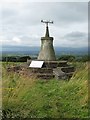
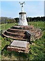
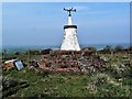
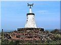
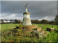
Destroyed Stone Circle. A gallows is said to have stood on the summit of Gallow Law. There is also a cairn with most of the stones now removed in which bones, supposedly human, were found.
The remains of this cairn are represented by a grass-covered mound 17.0m in diameter and 1.0m high with a few stones protruding through the surface. It is surmounted by a modern monument, inscribed;
"Gallow Hill Cairn, 1926. To the memory of James Smith of Threepwood, who died for civil and religious liberty, 1684'
Alex writes: Hill of GallowLaw is shown on the oldest map of the area I can find as having a stone circle of 50'0 diameter.
A record is also in a list of attractions compiled in the 17th C.
The newly placed information board says that the current Cairn was placed there as a marker for the stone circle in 1926.
Link to a panoramic image
You may be viewing yesterday's version of this page. To see the most up to date information please register for a free account.
Do not use the above information on other web sites or publications without permission of the contributor.
Nearby Images from Geograph Britain and Ireland:
©2017(licence)
©2019(licence)
©2019(licence)
©2019(licence)
©2020(licence)
The above images may not be of the site on this page, they are loaded from Geograph.
Please Submit an Image of this site or go out and take one for us!
Click here to see more info for this site
Nearby sites
Key: Red: member's photo, Blue: 3rd party photo, Yellow: other image, Green: no photo - please go there and take one, Grey: site destroyed
Download sites to:
KML (Google Earth)
GPX (GPS waypoints)
CSV (Garmin/Navman)
CSV (Excel)
To unlock full downloads you need to sign up as a Contributory Member. Otherwise downloads are limited to 50 sites.
Turn off the page maps and other distractions
Nearby sites listing. In the following links * = Image available
2.4km NW 313° Molmont Stone Circle (NS514371)
3.8km NE 55° The Dagon Stone* Standing Stone (Menhir) (NS56333746)
6.1km E 82° Loanfoot* Chambered Cairn (NS592360)
9.0km SW 233° Loch Lee Crannog* Crannog (NS45753027)
10.0km S 190° Ballochmyle* Rock Art (NS5111725565)
10.6km WSW 254° Craigie Broch Broch or Nuraghe (NS42793272)
10.7km WSW 253° Craigie Dun Hillfort (NS42803254)
10.9km WSW 252° Witches Stane (Craigie) Natural Stone / Erratic / Other Natural Feature (NS42683231)
11.2km WSW 255° Craigie Hill Fort Hillfort (NS42243276)
12.4km SW 221° Tarbolton Tumulus Cairn (NS4469926247)
12.4km SW 221° Coilsfield (Tarbolton) Rock Art (NS44692624)
13.1km SW 228° Tarbolton Cist* Cist (NS4327)
14.1km WNW 303° Buiston Crannog* Crannog (NS41554352)
14.7km N 0° Ballageich Hill* Cairn (NS53745005)
14.7km N 6° West Revoch Stone Row / Alignment (NS55104995)
16.7km W 265° Dun Donald Hillfort (NS36363451)
17.2km W 272° Drybridge* Standing Stone (Menhir) (NS35923644)
17.3km W 273° Dundonald Cursus Cursus (NS35893690)
17.3km WSW 259° Harpercroft Hillfort Hillfort (NS36003252)
17.3km W 273° Drybridge Neolithic Village Ancient Village or Settlement (NS3582336852)
17.4km W 259° Wardlaw Hill Fort Hillfort (NS35923276)
17.6km W 262° Kemp Law* Stone Fort or Dun (NS35583364)
18.1km W 277° Dreghorn Neolithic Village Ancient Village or Settlement (NS35183830)
18.5km NNW 339° Moyne Moor* Cairn (NS471529)
18.7km NNW 341° Covenanter's Stone* Stone Circle (NS47735333)
View more nearby sites and additional images


 We would like to know more about this location. Please feel free to add a brief description and any relevant information in your own language.
 Wir möchten mehr über diese Stätte erfahren. Bitte zögern Sie nicht, eine kurze Beschreibung und relevante Informationen in Deutsch hinzuzufügen.
 Nous aimerions en savoir encore un peu sur les lieux. S'il vous plaît n'hesitez pas à ajouter une courte description et tous les renseignements pertinents dans votre propre langue.
 Quisieramos informarnos un poco más de las lugares. No dude en añadir una breve descripción y otros datos relevantes en su propio idioma.