<< Our Photo Pages >> Bedlington Market Cross - Ancient Cross in England in Northumberland
Submitted by Anne T on Saturday, 13 October 2018 Page Views: 2565
Early Medieval (Dark Age)Site Name: Bedlington Market Cross Alternative Name: The Nail (Bedlington); The Cross (Bedlington)Country: England
NOTE: This site is 3.071 km away from the location you searched for.
County: Northumberland Type: Ancient Cross
Nearest Town: Bedlington
Map Ref: NZ2594981924
Latitude: 55.131012N Longitude: 1.59457W
Condition:
| 5 | Perfect |
| 4 | Almost Perfect |
| 3 | Reasonable but with some damage |
| 2 | Ruined but still recognisable as an ancient site |
| 1 | Pretty much destroyed, possibly visible as crop marks |
| 0 | No data. |
| -1 | Completely destroyed |
| 5 | Superb |
| 4 | Good |
| 3 | Ordinary |
| 2 | Not Good |
| 1 | Awful |
| 0 | No data. |
| 5 | Can be driven to, probably with disabled access |
| 4 | Short walk on a footpath |
| 3 | Requiring a bit more of a walk |
| 2 | A long walk |
| 1 | In the middle of nowhere, a nightmare to find |
| 0 | No data. |
| 5 | co-ordinates taken by GPS or official recorded co-ordinates |
| 4 | co-ordinates scaled from a detailed map |
| 3 | co-ordinates scaled from a bad map |
| 2 | co-ordinates of the nearest village |
| 1 | co-ordinates of the nearest town |
| 0 | no data |
Internal Links:
External Links:
I have visited· I would like to visit
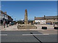
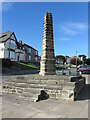
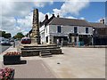
Anne T visited on 11th Oct 2018 - their rating: Cond: 3 Amb: 3 Access: 5 The Market Cross, Bedlington: We spotted this rather unusual market cross on our way to St Cuthbert's Church to see the tenth century carved slab, now inside the church. The road was less busy on our return, and we managed to pull into the small car park outside the hairdressers opposite (it was shut for the night) and I walked across the road to take some photographs.
I have to confess this is a pretty ugly structure, and well done to whoever uses it as a private parking spot. I was surprised to find this was a Grade II listed structure, built apparently in 1792.
The surrounding flower beds and town signs all proclaimed "The Bedlington Terrier", so presumably this is where those dogs originated.
")
This market cross is not typical of any other market crosses I've seen in Northumberland or the Scottish Borders, although I include it here for completeness and contrast. Whilst relatively modern (probably 18th century), it is still grade II listed and scheduled as Historic England List ID 1041360.
Also known locally as 'The Nail', Pastscape describes this as Monument No. 25407: "a market cross (obelisk) constructed of dressed sandstone blocks consisting of a shaft 4.0m high set upon a pedestal 4.8m by 4.5m and 1.0m high. No datable evidence was obtained." The Historic England entry adds there is a set of steps up to the obelisk on its eastern side.
An entry by Steve Ellwood on Geograph for Market Cross, Bedlington includes the following information: "The Swanns are one of the town’s oldest families, and Jim Swann’s early 18th century diaries suggest the Market Cross was built in 1782."
It is worth stopping off for a quick glimpse if visiting St Cuthbert's, just down the road, to see the carved tenth century slab (see nearby sites below).
You may be viewing yesterday's version of this page. To see the most up to date information please register for a free account.
Do not use the above information on other web sites or publications without permission of the contributor.
Nearby Images from Geograph Britain and Ireland:
©2011(licence)
©2022(licence)
©2017(licence)
©2016(licence)
©2011(licence)
The above images may not be of the site on this page, they are loaded from Geograph.
Please Submit an Image of this site or go out and take one for us!
Click here to see more info for this site
Nearby sites
Key: Red: member's photo, Blue: 3rd party photo, Yellow: other image, Green: no photo - please go there and take one, Grey: site destroyed
Download sites to:
KML (Google Earth)
GPX (GPS waypoints)
CSV (Garmin/Navman)
CSV (Excel)
To unlock full downloads you need to sign up as a Contributory Member. Otherwise downloads are limited to 50 sites.
Turn off the page maps and other distractions
Nearby sites listing. In the following links * = Image available
150m SE 138° St Cuthbert's Church (Bedlington)* Sculptured Stone (NZ2605081813)
1.9km ESE 113° Bebside Road Henge Henge (NZ277812)
5.1km NNW 338° St Andrew's Church (Bothal)* Ancient Cross (NZ2398986621)
5.2km SSW 204° Northumberlandia* Modern Stone Circle etc (NZ2384777182)
8.1km NNE 31° Woodhorn Cross* Ancient Cross (NZ3014288845)
8.4km NE 44° St Bartholomew's Church (Newbiggin by the Sea)* Ancient Cross (NZ3178588024)
9.2km SSW 213° Gardener's house crop mark, Dinnington Ancient Village or Settlement (NZ20977420)
9.6km WNW 295° St Cuthbert's Well (Mitford)* Holy Well or Sacred Spring (NZ1720685990)
10.2km SE 128° Old Hartley Blue Stone* Marker Stone (NZ341757)
10.4km SE 129° Old Hartley Standing Stone* Standing Stone (Menhir) (NZ341755)
10.5km SSW 194° Hazlerigg cropmark (North) Ancient Village or Settlement (NZ23467172)
10.7km NNW 346° Ulgham Cross* Ancient Cross (NZ2321892308)
10.8km SSW 194° Hazlerigg cropmark (South) Ancient Village or Settlement (NZ23327140)
12.0km SSE 160° Holy Stone (North Tyneside)* Ancient Cross (NZ30137066)
12.9km SW 226° St Mary The Virgin (Ponteland)* Ancient Cross (NZ1658872956)
15.3km NW 307° Clavering's Cross* Ancient Cross (NZ1359691047)
15.4km S 181° St. Mary's Well (Jesmond)* Holy Well or Sacred Spring (NZ2584366508)
16.3km S 180° Villa Reale cist, Jesmond* Cist (NZ26006562)
16.3km S 184° Exhibition Park Circle* Modern Stone Circle etc (NZ2476265651)
16.4km SW 217° Callerton Lane End cropmark Ancient Village or Settlement (NZ16106875)
16.5km W 271° Bolam Round Cairn (Northumberland)* Round Cairn (NZ0940082226)
16.7km W 273° St Andrew's Church (Bolam)* Ancient Cross (NZ0924482601)
16.8km S 184° The Ponteland Boulder* Rock Art (NZ24816518)
16.8km S 184° Great North Museum* Museum (NZ2485565168)
16.8km S 184° Great North Museum (Rock Art)* Museum (NZ2485365162)
View more nearby sites and additional images


 We would like to know more about this location. Please feel free to add a brief description and any relevant information in your own language.
 Wir möchten mehr über diese Stätte erfahren. Bitte zögern Sie nicht, eine kurze Beschreibung und relevante Informationen in Deutsch hinzuzufügen.
 Nous aimerions en savoir encore un peu sur les lieux. S'il vous plaît n'hesitez pas à ajouter une courte description et tous les renseignements pertinents dans votre propre langue.
 Quisieramos informarnos un poco más de las lugares. No dude en añadir una breve descripción y otros datos relevantes en su propio idioma.