<< Text Pages >> Banks East - Ancient Village or Settlement in England in Cumbria
Submitted by Anonymous on Thursday, 15 February 2001 Page Views: 4282
Multi-periodSite Name: Banks EastCountry: England
NOTE: This site is 2.042 km away from the location you searched for.
County: Cumbria Type: Ancient Village or Settlement
Map Ref: NY574647 Landranger Map Number: 86
Latitude: 54.975079N Longitude: 2.667057W
Condition:
| 5 | Perfect |
| 4 | Almost Perfect |
| 3 | Reasonable but with some damage |
| 2 | Ruined but still recognisable as an ancient site |
| 1 | Pretty much destroyed, possibly visible as crop marks |
| 0 | No data. |
| -1 | Completely destroyed |
| 5 | Superb |
| 4 | Good |
| 3 | Ordinary |
| 2 | Not Good |
| 1 | Awful |
| 0 | No data. |
| 5 | Can be driven to, probably with disabled access |
| 4 | Short walk on a footpath |
| 3 | Requiring a bit more of a walk |
| 2 | A long walk |
| 1 | In the middle of nowhere, a nightmare to find |
| 0 | No data. |
| 5 | co-ordinates taken by GPS or official recorded co-ordinates |
| 4 | co-ordinates scaled from a detailed map |
| 3 | co-ordinates scaled from a bad map |
| 2 | co-ordinates of the nearest village |
| 1 | co-ordinates of the nearest town |
| 0 | no data |
Be the first person to rate this site - see the 'Contribute!' box in the right hand menu.
Internal Links:
External Links:
Ancient Village / Settlement / Misc. Earthwork in Cumbria
Have you visited this site? Please contribute a description or any thoughts by adding a comment.
You may be viewing yesterday's version of this page. To see the most up to date information please register for a free account.
Do not use the above information on other web sites or publications without permission of the contributor.
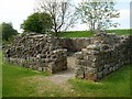
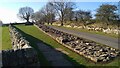
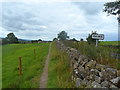
Nearby Images from Geograph Britain and Ireland:
©2011(licence)
©2008(licence)
©2023(licence)
©2014(licence)
©2010(licence)
The above images may not be of the site on this page, they are loaded from Geograph.
Please Submit an Image of this site or go out and take one for us!
Click here to see more info for this site
Nearby sites
Key: Red: member's photo, Blue: 3rd party photo, Yellow: other image, Green: no photo - please go there and take one, Grey: site destroyed
Download sites to:
KML (Google Earth)
GPX (GPS waypoints)
CSV (Garmin/Navman)
CSV (Excel)
To unlock full downloads you need to sign up as a Contributory Member. Otherwise downloads are limited to 50 sites.
Turn off the page maps and other distractions
Nearby sites listing. In the following links * = Image available
4.2km NNE 29° Waterhead Holy Well (King Water)* Holy Well or Sacred Spring (NY5951068340)
5.2km W 267° St Mary's Church (Walton)* Ancient Cross (NY5220864492)
5.3km SW 229° Brampton Castle Mound and Well* Misc. Earthwork (NY5333261284)
6.1km SSE 152° Tarnhouse Rigg Standing Stone (Menhir) (NY602593)
6.1km N 357° Gillalees Ring Cairn (NY571708)
6.1km NNW 342° Askerton Park* Ancient Village or Settlement (NY55567053)
6.2km ENE 75° Hadrian's Wall (Poltross Burn)* Stone Fort or Dun (NY6340166198)
6.8km ENE 63° Gilsland Spa Sulphur Spring Holy Well or Sacred Spring (NY63476776)
6.9km ENE 63° Gilsland Spa Well* Holy Well or Sacred Spring (NY6354067815)
6.9km N 2° Robin Hood's Well (Askerton) Holy Well or Sacred Spring (NY57677161)
7.0km WSW 250° Irthington Mill* Misc. Earthwork (NY50776237)
7.0km ENE 60° Popping Stone* Natural Stone / Erratic / Other Natural Feature (NY63556815)
7.2km ESE 119° Hartleyburn Common 2 Rock Art (NY6370061200)
7.2km ESE 118° The Curricks* Ancient Village or Settlement (NY63746122)
7.2km ESE 118° Hartleyburn Common 1e* Rock Art (NY6377261261)
7.3km ESE 117° Hartleyburn Common 1b Rock Art (NY6384861302)
7.3km ESE 117° Hartleyburn Common 1c Rock Art (NY6387161326)
7.3km ESE 117° Hartleyburn Common 1d Rock Art (NY6387361324)
7.3km ESE 117° Hartleyburn Common 1a* Rock Art (NY6387261311)
7.5km ESE 119° Hartleyburn Common 5* Rock Art (NY6396961024)
7.8km ESE 122° Hartleyburn Common 4 Rock Art (NY6398460470)
7.9km ESE 121° Hartleyburn Common 3* Rock Art (NY6412160581)
8.1km WSW 247° Hall Well (Irthington)* Holy Well or Sacred Spring (NY4992361627)
8.1km ESE 121° Haining House (Lambley)* Cairn (NY64296042)
8.1km WSW 246° Irthington Motte* Misc. Earthwork (NY49936151)
View more nearby sites and additional images


 We would like to know more about this location. Please feel free to add a brief description and any relevant information in your own language.
 Wir möchten mehr über diese Stätte erfahren. Bitte zögern Sie nicht, eine kurze Beschreibung und relevante Informationen in Deutsch hinzuzufügen.
 Nous aimerions en savoir encore un peu sur les lieux. S'il vous plaît n'hesitez pas à ajouter une courte description et tous les renseignements pertinents dans votre propre langue.
 Quisieramos informarnos un poco más de las lugares. No dude en añadir una breve descripción y otros datos relevantes en su propio idioma.