<< Our Photo Pages >> Hunstanworth Moor south - Standing Stone (Menhir) in England in County Durham
Submitted by HarperFox on Tuesday, 22 July 2014 Page Views: 3121
Neolithic and Bronze AgeSite Name: Hunstanworth Moor southCountry: England
NOTE: This site is 7.302 km away from the location you searched for.
County: County Durham Type: Standing Stone (Menhir)
Nearest Town: Stanhope Nearest Village: Townfield
Map Ref: NY9377745971
Latitude: 54.808565N Longitude: 2.098343W
Condition:
| 5 | Perfect |
| 4 | Almost Perfect |
| 3 | Reasonable but with some damage |
| 2 | Ruined but still recognisable as an ancient site |
| 1 | Pretty much destroyed, possibly visible as crop marks |
| 0 | No data. |
| -1 | Completely destroyed |
| 5 | Superb |
| 4 | Good |
| 3 | Ordinary |
| 2 | Not Good |
| 1 | Awful |
| 0 | No data. |
| 5 | Can be driven to, probably with disabled access |
| 4 | Short walk on a footpath |
| 3 | Requiring a bit more of a walk |
| 2 | A long walk |
| 1 | In the middle of nowhere, a nightmare to find |
| 0 | No data. |
| 5 | co-ordinates taken by GPS or official recorded co-ordinates |
| 4 | co-ordinates scaled from a detailed map |
| 3 | co-ordinates scaled from a bad map |
| 2 | co-ordinates of the nearest village |
| 1 | co-ordinates of the nearest town |
| 0 | no data |
Internal Links:
External Links:
I have visited· I would like to visit
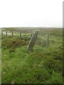
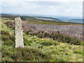
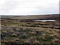
Anne T visited on 28th Aug 2017 - their rating: Cond: 3 Amb: 3 Access: 5 Hunstanworth Moor South, Near Townhead: This stone is marked on the OS Map as ‘stone’, and was easily found, although it seems like a tall boundary marker along the road from Townhead to Rookhope. As we drove along the road, we passed the northern boundary stone (see below), which isn’t marked on the map and was unexpected.
Haven’t been able to find out anything about these – not even a photograph on Geograph, as Andy Curtis has usually been out and about photographing all these places before us.
We backtracked to photograph the northern boundary stone on our way back to see the remains of the Edmundbyers Cross. I was impressed by all the now disused lead mining buildings and spoil heaps around here. It must have really busy in the not so distant past.
")
They're on the right hand side of the road as you travel northwest towards Townfield. They're about quarter of a mile apart, and I think intervisible. Bolt's Law hill rises behind them - they're edge-on to it. They're four-to-five feet tall and heavily covered with lichen. I can't see any surface marks or carvings. The first stone inclines sharply, the second is upright.
You may be viewing yesterday's version of this page. To see the most up to date information please register for a free account.
")
")
")
")
Do not use the above information on other web sites or publications without permission of the contributor.
Nearby Images from Geograph Britain and Ireland:
©2019(licence)
©2007(licence)
©2017(licence)
©2010(licence)
©2014(licence)
The above images may not be of the site on this page, they are loaded from Geograph.
Please Submit an Image of this site or go out and take one for us!
Click here to see more info for this site
Nearby sites
Key: Red: member's photo, Blue: 3rd party photo, Yellow: other image, Green: no photo - please go there and take one, Grey: site destroyed
Download sites to:
KML (Google Earth)
GPX (GPS waypoints)
CSV (Garmin/Navman)
CSV (Excel)
To unlock full downloads you need to sign up as a Contributory Member. Otherwise downloads are limited to 50 sites.
Turn off the page maps and other distractions
Nearby sites listing. In the following links * = Image available
568m NNE 21° Hunstanworth Moor north* Standing Stone (Menhir) (NY9398546500)
3.1km ENE 58° Old Man's Grave (Edmunbyers)* Marker Stone (NY96464763)
3.5km ESE 103° Dead Friar's Stone (Stanhope)* Marker Stone (NY9721545194)
5.3km NNE 32° St Mary the Virgin (Blanchland)* Ancient Cross (NY9659850408)
6.5km ESE 109° Feldon Plain (Muggleswick)* Marker Stone (NY9988843816)
6.7km E 100° Edmundbyers Cross (Muggleswick)* Ancient Cross (NZ0040244761)
6.9km SE 134° Heathery Burn Cave* Cave or Rock Shelter (NY98764118)
8.7km SE 134° Crawley Edge* Barrow Cemetery (NZ0007139875)
11.4km NNW 330° Burntridge Moor Rock Art (NY8811155864)
11.8km NNW 331° Crawberry Hill* Stone Circle (NY880563)
13.2km ESE 115° Tunstall Reservoir Rock Art (NZ0573040360)
13.3km NE 42° St George's Well (Minsteracres)* Holy Well or Sacred Spring (NZ0274555884)
14.3km S 188° Carr Crags 16 Rock Art (NY9187831833)
14.3km S 187° Carr Crags 18 Rock Art (NY9192231825)
14.3km S 188° Carr Crags 17 Rock Art (NY9183731785)
14.3km S 187° Carr Crags 7 Rock Art (NY9191431763)
14.3km S 187° Carr Crags 5 Rock Art (NY9191331759)
14.3km S 187° Carr Crags 6 Rock Art (NY9191231759)
14.3km S 187° Carr Crags 8 Rock Art (NY9190631754)
14.3km S 187° Carr Crags 4 Rock Art (NY9192231747)
14.3km S 187° Carr Crags 3 Rock Art (NY9192731742)
14.3km S 187° Carr Crags 4a Rock Art (NY9192931735)
14.3km S 187° Carr Crags 1, 12 & 13 Rock Art (NY9192131736)
14.3km S 187° Carr Crags 2, 9 & 10 Rock Art (NY9191931733)
14.4km S 187° Carr Crags 14 Rock Art (NY9189831730)
View more nearby sites and additional images


 We would like to know more about this location. Please feel free to add a brief description and any relevant information in your own language.
 Wir möchten mehr über diese Stätte erfahren. Bitte zögern Sie nicht, eine kurze Beschreibung und relevante Informationen in Deutsch hinzuzufügen.
 Nous aimerions en savoir encore un peu sur les lieux. S'il vous plaît n'hesitez pas à ajouter une courte description et tous les renseignements pertinents dans votre propre langue.
 Quisieramos informarnos un poco más de las lugares. No dude en añadir una breve descripción y otros datos relevantes en su propio idioma.