<< Other Photo Pages >> Leeds City Museum - Museum in England in Yorkshire (West)
Submitted by AKFisher on Friday, 07 March 2025 Page Views: 1019
MuseumsSite Name: Leeds City Museum Alternative Name: Leeds MuseumCountry: England
NOTE: This site is 0.573 km away from the location you searched for.
County: Yorkshire (West) Type: Museum
Nearest Town: Leeds
Map Ref: SE2993634036
Latitude: 53.801769N Longitude: 1.546957W
Condition:
| 5 | Perfect |
| 4 | Almost Perfect |
| 3 | Reasonable but with some damage |
| 2 | Ruined but still recognisable as an ancient site |
| 1 | Pretty much destroyed, possibly visible as crop marks |
| 0 | No data. |
| -1 | Completely destroyed |
| 5 | Superb |
| 4 | Good |
| 3 | Ordinary |
| 2 | Not Good |
| 1 | Awful |
| 0 | No data. |
| 5 | Can be driven to, probably with disabled access |
| 4 | Short walk on a footpath |
| 3 | Requiring a bit more of a walk |
| 2 | A long walk |
| 1 | In the middle of nowhere, a nightmare to find |
| 0 | No data. |
| 5 | co-ordinates taken by GPS or official recorded co-ordinates |
| 4 | co-ordinates scaled from a detailed map |
| 3 | co-ordinates scaled from a bad map |
| 2 | co-ordinates of the nearest village |
| 1 | co-ordinates of the nearest town |
| 0 | no data |
Internal Links:
External Links:
")
Admission to the museum is free of charge. Special exhibitions are hosted alongside a collection of displays from the Leeds Archive.
History
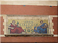
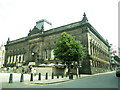
In 1819, a museum was established in Philosophical Hall, Bond Street, by the Leeds Philosophical and Literary Society, and in 1821 it opened to the public. In 1921, control of the museum was handed to the Corporation of Leeds which later became Leeds City Council. In 1862, Philosophical Hall was rebuilt in Park Row, where its stone portico can still be seen on the west side of the road.[1] In 1941, the museum building and artifacts were badly damaged by bombing.[2][3] In 1965 the museum was closed, and a few exhibits removed to a couple of rooms in the city library in 1966. The oversized Leeds Tiger, the giant moose skeleton and the carved wooden cart took up much of the space. In 1999 the museum went into storage, though researchers and the public could view items by appointment. In 2000, the resource centre at Yeadon opened, under the same appointment-to-view arrangement. In 2001, Leeds City Council bid for National Lottery cash, and in 2004, it was awarded £19.5 million,[4] so in 2005, the Leeds Mechanics' Institute building (designed by Cuthbert Brodrick and built 1865–1868)[5] began to be redesigned as Leeds City Museum, finally to reopen in 2008. It was redeveloped to a design by Austin-Smith:Lord architects and Buro Happold engineers.[6][7] The gallery and exhibit design was provided by Redman Design.[8][9].
Of note to Portal readers is a Wayland the Smith (Anglo-Saxon period) stone fragment in the museum's 2nd floor displays. See 3D rendering here: sketchfab.com/3d-models/wayland-fragment-leeds-city-museum-dc5ebafede5a4327a43206e21730cfbf. Description courtesy Wikipedia under commons licence.
For source and references see Wikipedia: en.wikipedia.org/wiki/Leeds_City_Museum and Leeds City Museum website: citymuseum.leeds.gov.uk/
Directions:
Leeds City Museum is located at Millennium Square, Leeds LS2 8BH, United Kingdom.
Note: Part of a Viking Age cross found during c19th rebuilding work in Leeds Minster. One of five examples of stone sculptures in Yorkshire that seem to show Wayland the Smith strapped into the ‘flying contrivance’ he used to escape King Níðuðr
You may be viewing yesterday's version of this page. To see the most up to date information please register for a free account.
")
Do not use the above information on other web sites or publications without permission of the contributor.
Nearby Images from Geograph Britain and Ireland:
![SE2934 : Leeds Museum [Former Civic Theatre] by Rick Carn](https://s3.geograph.org.uk/geophotos/02/73/85/2738515_8d3d97e5_120x120.jpg)
©2011(licence)

©2009(licence)
©2015(licence)
©2015(licence)
©2009(licence)
The above images may not be of the site on this page, they are loaded from Geograph.
Please Submit an Image of this site or go out and take one for us!
Click here to see more info for this site
Nearby sites
Key: Red: member's photo, Blue: 3rd party photo, Yellow: other image, Green: no photo - please go there and take one, Grey: site destroyed
Download sites to:
KML (Google Earth)
GPX (GPS waypoints)
CSV (Garmin/Navman)
CSV (Excel)
To unlock full downloads you need to sign up as a Contributory Member. Otherwise downloads are limited to 50 sites.
Turn off the page maps and other distractions
Nearby sites listing. In the following links * = Image available
729m ESE 115° Lady Well (Leeds) Holy Well or Sacred Spring (SE30603373)
1.0km SE 136° St Peter's Minster Church (Kirkgate) Ancient Cross (SE30653330)
1.1km ESE 115° Quarry Hill (Leeds) Ancient Village or Settlement (SE309336)
1.2km SSW 201° St Helen's Well (Holbeck) Holy Well or Sacred Spring (SE295329)
1.3km W 279° Gray Stone (Burley) Natural Stone / Erratic / Other Natural Feature (SE2865934229)
3.8km NE 46° Gipton Wood Ancient Village or Settlement (SE32653664)
6.7km NNW 338° Adel Cupstone* Rock Art (SE274402)
7.1km NE 56° Grim's Dyke* Misc. Earthwork (SE358380)
7.4km WNW 298° Horsforth Milestone* Rock Art (SE23323748)
8.5km NW 321° Gab Wood (2)* Carving (SE2460640625)
8.7km NW 326° Long Stone (Adel) Standing Stone (Menhir) (SE25014119)
9.2km N 10° Grey Stone (Harewood)* Rock Art (SE31474308)
9.6km WNW 290° St Wilfrid (Calverley) Sculptured Stone (SE208372)
10.3km WNW 293° Calverley Woods 2 (Leeds) Rock Art (SE2037737939)
10.3km WNW 293° Calverley Woods 3 (Leeds)* Rock Art (SE2036937923)
10.3km WNW 287° Calverley Woods Stone Circle (Leeds) Stone Circle (SE200370)
10.4km ENE 71° Barwick in Elmet Hillfort* Hillfort (SE398375)
10.6km WNW 292° Calverley Woods 1 (Leeds) Rock Art (SE20083791)
10.7km WNW 288° West Woods 1 (Calverley) Rock Art (SE19703731)
10.9km WNW 288° West Woods 2 (Calverley) Rock Art (SE195373)
11.2km SW 227° Pickel Well (Birstall) Holy Well or Sacred Spring (SE21802633)
11.2km NE 36° All Hallows (Bardsey)* Ancient Cross (SE3656143122)
11.3km WNW 281° Holy Well (Eccleshill) Holy Well or Sacred Spring (SE18783622)
11.7km SW 232° Moor Lane Well (Gomersal) Holy Well or Sacred Spring (SE20712677)
12.5km SW 225° Mannerly Well (Gomersal) Holy Well or Sacred Spring (SE21072515)
View more nearby sites and additional images


 We would like to know more about this location. Please feel free to add a brief description and any relevant information in your own language.
 Wir möchten mehr über diese Stätte erfahren. Bitte zögern Sie nicht, eine kurze Beschreibung und relevante Informationen in Deutsch hinzuzufügen.
 Nous aimerions en savoir encore un peu sur les lieux. S'il vous plaît n'hesitez pas à ajouter une courte description et tous les renseignements pertinents dans votre propre langue.
 Quisieramos informarnos un poco más de las lugares. No dude en añadir una breve descripción y otros datos relevantes en su propio idioma.