<< Our Photo Pages >> Sherburn Cross - Ancient Cross in England in Yorkshire (North)
Submitted by Mountwarren on Thursday, 21 October 2021 Page Views: 555
Early Medieval (Dark Age)Site Name: Sherburn CrossCountry: England
NOTE: This site is 2.138 km away from the location you searched for.
County: Yorkshire (North) Type: Ancient Cross
Nearest Town: Sherburn in Elmet
Map Ref: SE488335
Latitude: 53.795528N Longitude: 1.260648W
Condition:
| 5 | Perfect |
| 4 | Almost Perfect |
| 3 | Reasonable but with some damage |
| 2 | Ruined but still recognisable as an ancient site |
| 1 | Pretty much destroyed, possibly visible as crop marks |
| 0 | No data. |
| -1 | Completely destroyed |
| 5 | Superb |
| 4 | Good |
| 3 | Ordinary |
| 2 | Not Good |
| 1 | Awful |
| 0 | No data. |
| 5 | Can be driven to, probably with disabled access |
| 4 | Short walk on a footpath |
| 3 | Requiring a bit more of a walk |
| 2 | A long walk |
| 1 | In the middle of nowhere, a nightmare to find |
| 0 | No data. |
| 5 | co-ordinates taken by GPS or official recorded co-ordinates |
| 4 | co-ordinates scaled from a detailed map |
| 3 | co-ordinates scaled from a bad map |
| 2 | co-ordinates of the nearest village |
| 1 | co-ordinates of the nearest town |
| 0 | no data |
Internal Links:
External Links:
")
The cross is grade 2 listed by Historic England.
Probable C17 base with earlier crosshead. Magnesian limestone.
Approximately 1 metre high. Truncated shaft with decorated wheel head and
portion of carved base of a stone cross.
Historic England listing
You may be viewing yesterday's version of this page. To see the most up to date information please register for a free account.
")
Do not use the above information on other web sites or publications without permission of the contributor.
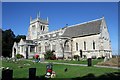
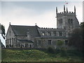
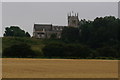
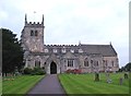
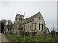
Nearby Images from Geograph Britain and Ireland:
©2006(licence)
©2006(licence)
©2014(licence)
©2012(licence)
©2018(licence)
The above images may not be of the site on this page, they are loaded from Geograph.
Please Submit an Image of this site or go out and take one for us!
Click here to see more info for this site
Nearby sites
Key: Red: member's photo, Blue: 3rd party photo, Yellow: other image, Green: no photo - please go there and take one, Grey: site destroyed
Download sites to:
KML (Google Earth)
GPX (GPS waypoints)
CSV (Garmin/Navman)
CSV (Excel)
To unlock full downloads you need to sign up as a Contributory Member. Otherwise downloads are limited to 50 sites.
Turn off the page maps and other distractions
Nearby sites listing. In the following links * = Image available
3.1km NNW 342° Saxton Church Ancient Cross (SE478364)
6.6km NW 304° St Ricarius (Aberford) Ancient Cross (SE4331037170)
7.8km NNE 14° St John the Baptist (Kirkby Wharfe) Ancient Cross (SE50604107)
9.1km S 190° Angel Moon Field Cairn (SE47342449)
9.2km S 190° Round Hill Field (Ferrybridge) Cairn (SE47332444)
9.4km S 189° Ferrybridge Henge Henge (SE47462424)
9.5km S 188° Ferrybridge N Timber Circle (SE476241)
9.6km S 188° Ferrybridge N Timber Circle (SE476240)
9.8km WNW 295° Barwick in Elmet Hillfort* Hillfort (SE398375)
11.8km NNW 347° Newton Kyme Henge Henge (SE45934499)
12.4km SW 215° Featherstone Cursus Cursus (SE418232)
12.9km NNW 344° St Helen's Well (Boston Spa)* Holy Well or Sacred Spring (SE45134583)
13.7km WNW 290° Grim's Dyke* Misc. Earthwork (SE358380)
15.5km NW 309° All Hallows (Bardsey)* Ancient Cross (SE3656143122)
15.9km NW 323° Collingham Crosses* Ancient Cross (SE3901546096)
16.1km ENE 75° Danes Hills (Riccall) Barrow Cemetery (SE6440837723)
16.4km WNW 282° Gipton Wood Ancient Village or Settlement (SE32653664)
16.9km N 357° St Helen's Church (Bilton-in-Ainsty)* Ancient Cross (SE476504)
17.8km W 271° Quarry Hill (Leeds) Ancient Village or Settlement (SE309336)
18.1km W 270° St Peter's Minster Church (Kirkgate) Ancient Cross (SE30653330)
18.1km W 271° Lady Well (Leeds) Holy Well or Sacred Spring (SE30603373)
18.9km SW 216° All Saints (Crofton) Ancient Cross (SE37781812)
19.3km W 269° St Helen's Well (Holbeck) Holy Well or Sacred Spring (SE295329)
19.7km NNE 31° The Hob Stone* Sculptured Stone (SE5891450417)
19.8km WNW 300° Grey Stone (Harewood)* Rock Art (SE31474308)
View more nearby sites and additional images


 We would like to know more about this location. Please feel free to add a brief description and any relevant information in your own language.
 Wir möchten mehr über diese Stätte erfahren. Bitte zögern Sie nicht, eine kurze Beschreibung und relevante Informationen in Deutsch hinzuzufügen.
 Nous aimerions en savoir encore un peu sur les lieux. S'il vous plaît n'hesitez pas à ajouter une courte description et tous les renseignements pertinents dans votre propre langue.
 Quisieramos informarnos un poco más de las lugares. No dude en añadir una breve descripción y otros datos relevantes en su propio idioma.