<< Our Photo Pages >> Stainborough Castle - Hillfort in England in Yorkshire (South)
Submitted by andy_h on Friday, 23 December 2005 Page Views: 12562
Iron Age and Later PrehistorySite Name: Stainborough Castle Alternative Name: Wentworth CastleCountry: England County: Yorkshire (South) Type: Hillfort
Nearest Town: Barnsley
Map Ref: SE315030
Latitude: 53.522730N Longitude: 1.526348W
Condition:
| 5 | Perfect |
| 4 | Almost Perfect |
| 3 | Reasonable but with some damage |
| 2 | Ruined but still recognisable as an ancient site |
| 1 | Pretty much destroyed, possibly visible as crop marks |
| 0 | No data. |
| -1 | Completely destroyed |
| 5 | Superb |
| 4 | Good |
| 3 | Ordinary |
| 2 | Not Good |
| 1 | Awful |
| 0 | No data. |
| 5 | Can be driven to, probably with disabled access |
| 4 | Short walk on a footpath |
| 3 | Requiring a bit more of a walk |
| 2 | A long walk |
| 1 | In the middle of nowhere, a nightmare to find |
| 0 | No data. |
| 5 | co-ordinates taken by GPS or official recorded co-ordinates |
| 4 | co-ordinates scaled from a detailed map |
| 3 | co-ordinates scaled from a bad map |
| 2 | co-ordinates of the nearest village |
| 1 | co-ordinates of the nearest town |
| 0 | no data |
Internal Links:
External Links:
I have visited· I would like to visit
elad13 would like to visit
ravenmoon3 visited - their rating: Cond: 3 Amb: 4 Access: 3 Worth a visit
")
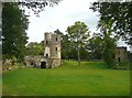
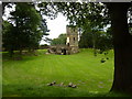
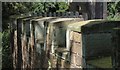
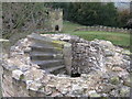
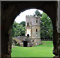
Remains of an Iron Age Hillfort just south of Barnsley, this hilltop has seen an active history. It is thought to have been reused in Medieval times, followed by the building of a gothic folly by the Earl of Strafford circa 1730.
The site is now included in the Gardens of Wentworth Castle, a country house built in 1672 by Thomas Wentworth on the site of old Stainborough Hall.
You may be viewing yesterday's version of this page. To see the most up to date information please register for a free account.
")
Do not use the above information on other web sites or publications without permission of the contributor.
Nearby Images from Geograph Britain and Ireland:
©2009(licence)
©2010(licence)
©2014(licence)
©2008(licence)
©2020(licence)
The above images may not be of the site on this page, they are loaded from Geograph.
Please Submit an Image of this site or go out and take one for us!
Click here to see more info for this site
Nearby sites
Key: Red: member's photo, Blue: 3rd party photo, Yellow: other image, Green: no photo - please go there and take one, Grey: site destroyed
Download sites to:
KML (Google Earth)
GPX (GPS waypoints)
CSV (Garmin/Navman)
CSV (Excel)
To unlock full downloads you need to sign up as a Contributory Member. Otherwise downloads are limited to 50 sites.
Turn off the page maps and other distractions
Nearby sites listing. In the following links * = Image available
3.2km NE 52° Worsborough Common Hillfort (SE340050)
5.5km SSW 206° Deepcar Mesolithic Settlement* Ancient Village or Settlement (SK291981)
5.8km NNW 329° All Saints (Cawthorne)* Ancient Cross (SE28460793)
6.1km WSW 254° Roughbirchworth Camp* Ancient Village or Settlement (SE256013)
6.8km SSW 208° Dragon's Well (Bolsterstone) Holy Well or Sacred Spring (SK28279697)
6.9km SSE 164° Robin Hood Well (Yorkshire South)* Holy Well or Sacred Spring (SK334964)
7.0km S 189° Dragon Well (Wharncliffe) Holy Well or Sacred Spring (SK305961)
7.0km S 184° Burnt Hill Plantation* Rock Art (SK310960)
8.1km W 263° Cubley Cross* Ancient Cross (SE234020)
8.8km WSW 247° St James's Well (Midhopestones)* Holy Well or Sacred Spring (SK234995)
8.9km SE 142° St. Helen's Well (Thorpe Hesley) Holy Well or Sacred Spring (SK370960)
9.7km SSE 157° Ecclesfield* Ancient Cross (SK353941)
10.0km SW 231° Ewden Beck* Stone Circle (SK23819664)
10.4km SSW 212° Handsome Cross Ancient Cross (SK26019412)
10.7km SW 220° Bar Dyke (Yorkshire)* Misc. Earthwork (SK247947)
10.9km SW 220° Bar Dyke Ring* Ring Cairn (SK245946)
10.9km SW 220° Apronful of Stones (Bradfield) Cairn (SK2448094582)
11.2km SE 135° Scholes Wood* Hillfort (SK395952)
11.4km SE 128° Roman Ridge (Rotherham)* Misc. Earthwork (SK40499598)
11.5km SSW 205° St Nicholas (Bradfield) Ancient Cross (SK26729254)
12.4km S 182° Wadsley Common* Stone Circle (SK312906)
13.1km ENE 58° Ringstone Hill (Brierley) Stone Circle (SE42571005)
13.5km SSE 153° Wincobank* Vitrified Fort (SK378910)
14.1km ENE 58° South Kirby Camp* Hillfort (SE435105)
15.6km SSE 157° Darnall Common* Modern Stone Circle etc (SK378887)
View more nearby sites and additional images


 We would like to know more about this location. Please feel free to add a brief description and any relevant information in your own language.
 Wir möchten mehr über diese Stätte erfahren. Bitte zögern Sie nicht, eine kurze Beschreibung und relevante Informationen in Deutsch hinzuzufügen.
 Nous aimerions en savoir encore un peu sur les lieux. S'il vous plaît n'hesitez pas à ajouter une courte description et tous les renseignements pertinents dans votre propre langue.
 Quisieramos informarnos un poco más de las lugares. No dude en añadir una breve descripción y otros datos relevantes en su propio idioma.