<< Our Photo Pages >> The Shall Cross - Ancient Cross in England in Derbyshire
Submitted by TimPrevett on Thursday, 17 May 2007 Page Views: 8124
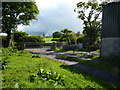
Early Medieval (Dark Age)Site Name: The Shall CrossCountry: England
NOTE: This site is 1.3 km away from the location you searched for.
County: Derbyshire Type: Ancient Cross
Nearest Town: Whaley Bridge
Map Ref: SK0165579615
Latitude: 53.313468N Longitude: 1.976621W
Condition:
| 5 | Perfect |
| 4 | Almost Perfect |
| 3 | Reasonable but with some damage |
| 2 | Ruined but still recognisable as an ancient site |
| 1 | Pretty much destroyed, possibly visible as crop marks |
| 0 | No data. |
| -1 | Completely destroyed |
| 5 | Superb |
| 4 | Good |
| 3 | Ordinary |
| 2 | Not Good |
| 1 | Awful |
| 0 | No data. |
| 5 | Can be driven to, probably with disabled access |
| 4 | Short walk on a footpath |
| 3 | Requiring a bit more of a walk |
| 2 | A long walk |
| 1 | In the middle of nowhere, a nightmare to find |
| 0 | No data. |
| 5 | co-ordinates taken by GPS or official recorded co-ordinates |
| 4 | co-ordinates scaled from a detailed map |
| 3 | co-ordinates scaled from a bad map |
| 2 | co-ordinates of the nearest village |
| 1 | co-ordinates of the nearest town |
| 0 | no data |
Internal Links:
External Links:
")
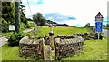
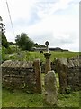
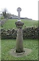
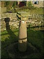
The remains of a 9th Century cross, within a curved enclosure, mounted by a relatively recent sundial.
You may be viewing yesterday's version of this page. To see the most up to date information please register for a free account.
")
")
")
Do not use the above information on other web sites or publications without permission of the contributor.
Nearby Images from Geograph Britain and Ireland:
©2017(licence)
©2017(licence)
©2019(licence)
©2006(licence)
©2011(licence)
The above images may not be of the site on this page, they are loaded from Geograph.
Please Submit an Image of this site or go out and take one for us!
Click here to see more info for this site
Nearby sites
Key: Red: member's photo, Blue: 3rd party photo, Yellow: other image, Green: no photo - please go there and take one, Grey: site destroyed
Download sites to:
KML (Google Earth)
GPX (GPS waypoints)
CSV (Garmin/Navman)
CSV (Excel)
To unlock full downloads you need to sign up as a Contributory Member. Otherwise downloads are limited to 50 sites.
Turn off the page maps and other distractions
Nearby sites listing. In the following links * = Image available
673m ESE 106° Ladder Hill* Ring Cairn (SK0230579434)
2.5km WSW 239° Windgather Rocks Cup-Mark Stone Rock Art (SJ995783)
2.6km NW 316° Hawkhurst Head* Standing Stone (Menhir) (SJ99838149)
2.9km NW 325° Ringstone (Whaley Bridge) Stone Circle (SK000820)
3.0km NW 315° The Dipping Stone* Ancient Cross (SJ99558171)
3.1km ENE 70° Nanny Well* Holy Well or Sacred Spring (SK046807)
3.5km WNW 295° Stone near Higher Cornfield Farm* Standing Stone (Menhir) (SJ985811)
3.9km W 274° Reed Hill* Round Barrow(s) (SJ978799)
3.9km ESE 107° Castle Naze* Hillfort (SK054785)
3.9km SSW 199° Foxlowe Edge* Standing Stone (Menhir) (SK0038675907)
4.0km WSW 258° Charles Head* Round Barrow(s) (SJ977788)
4.3km ENE 74° St Thomas Becket (Chapel en le Frith)* Ancient Cross (SK0574580820)
4.4km NNE 25° Chinley Churn Barrow Round Barrow(s) (SK035836)
4.5km W 263° Further Harrop* Round Barrow(s) (SJ972791)
4.6km WNW 292° Bowstones* Ancient Cross (SJ9739181309)
4.6km ENE 73° Nanny's Well (Chapel le Frith) Holy Well or Sacred Spring (SK061810)
4.7km W 277° Sponds Hill S Round Barrow(s) (SJ970802)
4.7km W 278° Sponds Hill N* Round Barrow(s) (SJ970803)
5.0km E 101° Cow Low* Round Barrow(s) (SK0653378666)
5.1km ESE 106° Lady Low Barrow* Round Cairn (SK06537818)
5.5km SW 236° Blue Boar Farm* Round Barrow(s) (SJ971765)
5.5km WNW 291° Knights Low W Round Barrow(s) (SJ965816)
5.5km WNW 292° Knightslow Wood E Round Barrow(s) (SJ965817)
5.5km WNW 292° Knightslow Wood W* Round Barrow(s) (SJ965817)
5.6km WNW 291° Knights Low E* Round Barrow(s) (SJ964816)
View more nearby sites and additional images


 We would like to know more about this location. Please feel free to add a brief description and any relevant information in your own language.
 Wir möchten mehr über diese Stätte erfahren. Bitte zögern Sie nicht, eine kurze Beschreibung und relevante Informationen in Deutsch hinzuzufügen.
 Nous aimerions en savoir encore un peu sur les lieux. S'il vous plaît n'hesitez pas à ajouter une courte description et tous les renseignements pertinents dans votre propre langue.
 Quisieramos informarnos un poco más de las lugares. No dude en añadir una breve descripción y otros datos relevantes en su propio idioma.