<< Our Photo Pages >> Axstone cross - Ancient Cross in England in Cheshire
Submitted by astronomer on Friday, 23 December 2005 Page Views: 7454
Early Medieval (Dark Age)Site Name: Axstone crossCountry: England
NOTE: This site is 5.366 km away from the location you searched for.
County: Cheshire Type: Ancient Cross
Nearest Town: Holmes Chapel Nearest Village: Goostrey
Map Ref: SJ789706
Latitude: 53.232013N Longitude: 2.317554W
Condition:
| 5 | Perfect |
| 4 | Almost Perfect |
| 3 | Reasonable but with some damage |
| 2 | Ruined but still recognisable as an ancient site |
| 1 | Pretty much destroyed, possibly visible as crop marks |
| 0 | No data. |
| -1 | Completely destroyed |
| 5 | Superb |
| 4 | Good |
| 3 | Ordinary |
| 2 | Not Good |
| 1 | Awful |
| 0 | No data. |
| 5 | Can be driven to, probably with disabled access |
| 4 | Short walk on a footpath |
| 3 | Requiring a bit more of a walk |
| 2 | A long walk |
| 1 | In the middle of nowhere, a nightmare to find |
| 0 | No data. |
| 5 | co-ordinates taken by GPS or official recorded co-ordinates |
| 4 | co-ordinates scaled from a detailed map |
| 3 | co-ordinates scaled from a bad map |
| 2 | co-ordinates of the nearest village |
| 1 | co-ordinates of the nearest town |
| 0 | no data |
Internal Links:
External Links:
")
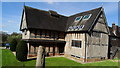
This is an odd one. This Mercian cross probably originally stood on Heaton Low SJ955628 on a bronze age burial mound. Then it was moved, to SJ952623 near to Axstones Spring. This is where it was found in the mid 1960s by writer and archaeologist, Alan Garner, who removed it for safekeeping to his home at Goostrey. It now lives at his home, Toad Hall, overlooked by the great radio telescope at Jodrell Bank.
You may be viewing yesterday's version of this page. To see the most up to date information please register for a free account.
")
Do not use the above information on other web sites or publications without permission of the contributor.
Nearby Images from Geograph Britain and Ireland:
©2019(licence)

©2013(licence)
©2015(licence)
©2014(licence)
©2009(licence)
The above images may not be of the site on this page, they are loaded from Geograph.
Please Submit an Image of this site or go out and take one for us!
Click here to see more info for this site
Nearby sites
Key: Red: member's photo, Blue: 3rd party photo, Yellow: other image, Green: no photo - please go there and take one, Grey: site destroyed
Download sites to:
KML (Google Earth)
GPX (GPS waypoints)
CSV (Garmin/Navman)
CSV (Excel)
To unlock full downloads you need to sign up as a Contributory Member. Otherwise downloads are limited to 50 sites.
Turn off the page maps and other distractions
Nearby sites listing. In the following links * = Image available
282m SE 135° Jodrell Bank* Barrow Cemetery (SJ791704)
2.5km NE 44° Old Withington* Barrow Cemetery (SJ80677240)
3.6km SSE 161° St Peter (Swettenham) Ancient Cross (SJ80086718)
3.9km NE 34° Astle Park Round Barrow(s) (SJ811738)
4.6km SSE 148° Swettenham Hall* Round Barrow(s) (SJ813667)
5.4km ENE 64° Capesthorne Hall (NW) Round Barrow(s) (SJ838730)
5.9km ENE 67° Capesthorne Hall (NE)* Round Barrow(s) (SJ843729)
5.9km ENE 70° Capesthorne Hall (SE)* Round Barrow(s) (SJ845726)
6.2km ENE 58° Sodger's Hump* Round Barrow(s) (SJ842739)
6.5km SSE 160° Somerford Round Barrow Round Barrow(s) (SJ811645)
7.7km ENE 59° Birtles Hall Round Barrow(s) (SJ856745)
8.3km SSE 150° Loachbrook Farm* Long Barrow (SJ830634)
8.3km E 85° Lower Pexhill Round Barrow(s) (SJ872713)
8.6km NNW 337° Nether Knutsford* Round Barrow(s) (SJ756785)
8.6km E 80° Bearhurst Farm* Round Barrow(s) (SJ874720)
9.5km NE 49° Great Merestone Marker Stone (SJ86137677)
9.6km NNE 12° Lindow* Ancient Trackway (SJ810800)
9.9km NE 44° Armada Beacon* Round Barrow(s) (SJ858777)
10.0km NE 43° Wizard's Well* Holy Well or Sacred Spring (SJ858778)
10.0km ENE 77° New Farm, Henbury* Stone Circle (SJ887728)
10.0km NE 45° Wishing Well (Alderley Edge)* Holy Well or Sacred Spring (SJ860777)
10.0km NE 45° Engine Vein, Alderley Edge Copper Mines* Ancient Mine, Quarry or other Industry (SJ861776)
10.0km NE 45° Golden Stone (Alderley Edge)* Standing Stone (Menhir) (SJ861776)
10.1km NE 44° Holy Well (Alderley Edge)* Holy Well or Sacred Spring (SJ85907786)
10.2km NE 45° Wizard's Cave Cave or Rock Shelter (SJ86087782)
View more nearby sites and additional images


 We would like to know more about this location. Please feel free to add a brief description and any relevant information in your own language.
 Wir möchten mehr über diese Stätte erfahren. Bitte zögern Sie nicht, eine kurze Beschreibung und relevante Informationen in Deutsch hinzuzufügen.
 Nous aimerions en savoir encore un peu sur les lieux. S'il vous plaît n'hesitez pas à ajouter une courte description et tous les renseignements pertinents dans votre propre langue.
 Quisieramos informarnos un poco más de las lugares. No dude en añadir una breve descripción y otros datos relevantes en su propio idioma.