<< Our Photo Pages >> Marton Churchyard Cross - Ancient Cross in England in Cheshire
Submitted by wmh on Wednesday, 27 August 2025 Page Views: 1133
Medieval (High and Late)Site Name: Marton Churchyard CrossCountry: England
NOTE: This site is 2.196 km away from the location you searched for.
County: Cheshire Type: Ancient Cross
Nearest Town: Congleton Nearest Village: Marton
Map Ref: SJ8502967982
Latitude: 53.208690N Longitude: 2.225613W
Condition:
| 5 | Perfect |
| 4 | Almost Perfect |
| 3 | Reasonable but with some damage |
| 2 | Ruined but still recognisable as an ancient site |
| 1 | Pretty much destroyed, possibly visible as crop marks |
| 0 | No data. |
| -1 | Completely destroyed |
| 5 | Superb |
| 4 | Good |
| 3 | Ordinary |
| 2 | Not Good |
| 1 | Awful |
| 0 | No data. |
| 5 | Can be driven to, probably with disabled access |
| 4 | Short walk on a footpath |
| 3 | Requiring a bit more of a walk |
| 2 | A long walk |
| 1 | In the middle of nowhere, a nightmare to find |
| 0 | No data. |
| 5 | co-ordinates taken by GPS or official recorded co-ordinates |
| 4 | co-ordinates scaled from a detailed map |
| 3 | co-ordinates scaled from a bad map |
| 2 | co-ordinates of the nearest village |
| 1 | co-ordinates of the nearest town |
| 0 | no data |
Internal Links:
External Links:
")
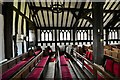
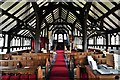
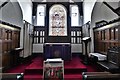
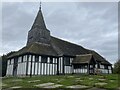
The shaft is square tapering to octagonal. The cross base now sits on a modern slab. Historic England entry 1017841.
EDITOR'S NOTE: We are bending our normal rules of not allowing sites later than 1100CE for this beautiful cross and church.
You may be viewing yesterday's version of this page. To see the most up to date information please register for a free account.
")
Do not use the above information on other web sites or publications without permission of the contributor.
Nearby Images from Geograph Britain and Ireland:
©2019(licence)
©2019(licence)
©2019(licence)
©2021(licence)

©2010(licence)
The above images may not be of the site on this page, they are loaded from Geograph.
Please Submit an Image of this site or go out and take one for us!
Click here to see more info for this site
Nearby sites
Key: Red: member's photo, Blue: 3rd party photo, Yellow: other image, Green: no photo - please go there and take one, Grey: site destroyed
Download sites to:
KML (Google Earth)
GPX (GPS waypoints)
CSV (Garmin/Navman)
CSV (Excel)
To unlock full downloads you need to sign up as a Contributory Member. Otherwise downloads are limited to 50 sites.
Turn off the page maps and other distractions
Nearby sites listing. In the following links * = Image available
3.9km WSW 251° Swettenham Hall* Round Barrow(s) (SJ813667)
4.0km NNE 33° Lower Pexhill Round Barrow(s) (SJ872713)
4.6km N 353° Capesthorne Hall (SE)* Round Barrow(s) (SJ845726)
4.7km NNE 30° Bearhurst Farm* Round Barrow(s) (SJ874720)
5.0km N 351° Capesthorne Hall (NE)* Round Barrow(s) (SJ843729)
5.0km W 261° St Peter (Swettenham) Ancient Cross (SJ80086718)
5.0km SSW 204° Loachbrook Farm* Long Barrow (SJ830634)
5.2km S 170° Congleton Museum* Museum (SJ859629)
5.2km NNW 346° Capesthorne Hall (NW) Round Barrow(s) (SJ838730)
5.2km SW 228° Somerford Round Barrow Round Barrow(s) (SJ811645)
6.0km N 352° Sodger's Hump* Round Barrow(s) (SJ842739)
6.0km NE 37° New Farm, Henbury* Stone Circle (SJ887728)
6.2km NW 315° Old Withington* Barrow Cemetery (SJ80677240)
6.4km WNW 292° Jodrell Bank* Barrow Cemetery (SJ791704)
6.4km S 185° Astbury Churchyard* Round Barrow(s) (SJ845616)
6.5km S 183° St Marys (Astbury)* Ancient Cross (SJ847615)
6.5km N 5° Birtles Hall Round Barrow(s) (SJ856745)
6.6km WNW 293° Axstone cross* Ancient Cross (SJ789706)
6.7km ENE 76° Woodhouse End* Round Barrow(s) (SJ915696)
7.0km SE 129° Bosley Cloud (1)* Standing Stone (Menhir) (SJ905636)
7.0km NW 326° Astle Park Round Barrow(s) (SJ811738)
7.1km ENE 77° Gawsworth henge* Henge (SJ920696)
7.2km SE 129° Bosley Cloud (2)* Standing Stone (Menhir) (SJ906634)
7.3km ENE 75° Broad Oak Farm* Round Barrow(s) (SJ921699)
8.0km SE 136° The Bridestones (Cheshire)* Chambered Tomb (SJ9058962190)
View more nearby sites and additional images


 We would like to know more about this location. Please feel free to add a brief description and any relevant information in your own language.
 Wir möchten mehr über diese Stätte erfahren. Bitte zögern Sie nicht, eine kurze Beschreibung und relevante Informationen in Deutsch hinzuzufügen.
 Nous aimerions en savoir encore un peu sur les lieux. S'il vous plaît n'hesitez pas à ajouter une courte description et tous les renseignements pertinents dans votre propre langue.
 Quisieramos informarnos un poco más de las lugares. No dude en añadir una breve descripción y otros datos relevantes en su propio idioma.