<< Our Photo Pages >> Gorsedd Bran - Barrow Cemetery in Wales in Denbighshire
Submitted by Postman on Sunday, 21 October 2012 Page Views: 2946
Neolithic and Bronze AgeSite Name: Gorsedd BranCountry: Wales
NOTE: This site is 0.132 km away from the location you searched for.
County: Denbighshire Type: Barrow Cemetery
Nearest Town: Denbigh Nearest Village: Nantglyn
Map Ref: SH968597
Latitude: 53.124447N Longitude: 3.543664W
Condition:
| 5 | Perfect |
| 4 | Almost Perfect |
| 3 | Reasonable but with some damage |
| 2 | Ruined but still recognisable as an ancient site |
| 1 | Pretty much destroyed, possibly visible as crop marks |
| 0 | No data. |
| -1 | Completely destroyed |
| 5 | Superb |
| 4 | Good |
| 3 | Ordinary |
| 2 | Not Good |
| 1 | Awful |
| 0 | No data. |
| 5 | Can be driven to, probably with disabled access |
| 4 | Short walk on a footpath |
| 3 | Requiring a bit more of a walk |
| 2 | A long walk |
| 1 | In the middle of nowhere, a nightmare to find |
| 0 | No data. |
| 5 | co-ordinates taken by GPS or official recorded co-ordinates |
| 4 | co-ordinates scaled from a detailed map |
| 3 | co-ordinates scaled from a bad map |
| 2 | co-ordinates of the nearest village |
| 1 | co-ordinates of the nearest town |
| 0 | no data |
Internal Links:
External Links:
I have visited· I would like to visit
SolarMegalith would like to visit
")
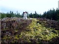
On my first trip up here I was looking for the eastern pair, couldn't find them, so this time I concentrated on the very highest pair of barrows, the trig point being on top of one of them I thought it would be easy to find, it wasn't.
After locating the top, I barged into the trees, then after many scratches and scrapes I came out into the clearing and there it was. It is not easy to find. The barrow is in good condition apart from the trig point on its top. The other neighbouring barrow has a clearing of its own too but its either gone or so slight as to disappear under the copious covering of heather and mosses.
This would be such a good place if not for the blasted forestry commission, even if they all came down tomorrow it would still be ruined, I've seen the devastation the felling can cause, so this is as good as it gets, in this lifetime.
You may be viewing yesterday's version of this page. To see the most up to date information please register for a free account.
")
Do not use the above information on other web sites or publications without permission of the contributor.
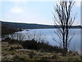
Nearby Images from Geograph Britain and Ireland:
©2013(licence)
©2005(licence)
©2014(licence)
©2014(licence)
©2010(licence)
The above images may not be of the site on this page, they are loaded from Geograph.
Please Submit an Image of this site or go out and take one for us!
Click here to see more info for this site
Nearby sites
Key: Red: member's photo, Blue: 3rd party photo, Yellow: other image, Green: no photo - please go there and take one, Grey: site destroyed
Download sites to:
KML (Google Earth)
GPX (GPS waypoints)
CSV (Garmin/Navman)
CSV (Excel)
To unlock full downloads you need to sign up as a Contributory Member. Otherwise downloads are limited to 50 sites.
Turn off the page maps and other distractions
Nearby sites listing. In the following links * = Image available
2.5km WNW 290° Rhiwiau Barrow* Round Barrow(s) (SH94466063)
2.7km SE 127° Brenig 47* Round Cairn (SH98925804)
2.7km SE 140° Brenig Mesolithic Camp Site Ancient Village or Settlement (SH985576)
2.7km ESE 110° Tir Mostyn Kerb Cairns Cairn (SH99345870)
2.8km SSE 158° Brenig 40* Round Barrow(s) (SH97785711)
2.9km SSE 147° Boncyn Arian* Round Barrow(s) (SH98305726)
2.9km SSE 157° Brenig 41* Round Barrow(s) (SH97905702)
2.9km SSE 147° Brenig 44* Timber Circle (SH98345720)
3.1km SSE 166° Brenig 42* Round Barrow(s) (SH975567)
3.1km WNW 292° Blaen y Cwm Barrow* Round Barrow(s) (SH93916091)
3.3km SSE 146° Brenig 46* Cairn (SH98585691)
3.8km SE 144° Brenig 51* Cairn (SH98985656)
3.9km SSE 148° Brenig 8* Round Barrow(s) (SH98805636)
3.9km SSE 156° Brenig 14 Cairn (SH983561)
4.3km SE 140° Brenig 5. Ring Cairn (SH995564)
4.3km SE 140° Brenig 6* Cairn (SH99525631)
4.3km SE 140° Maen Cleddau* Natural Stone / Erratic / Other Natural Feature (SH99515630)
4.5km ESE 110° Twr-yr-Hill* Round Barrow(s) (SJ010581)
5.3km W 270° Aled Isaf Reservoir Standing Stone* Standing Stone (Menhir) (SH915598)
5.5km WNW 296° Boncyn Crwn Barrow* Round Barrow(s) (SH9192062170)
5.5km NW 308° Cau Du Barrow* Round Barrow(s) (SH9256063160)
5.5km W 268° Llyn Aled Isaf Ancient Village or Settlement (SH91295959)
6.2km SW 225° Nant Heilyn* Ring Cairn (SH92355543)
6.6km S 183° Hafod-y-llan Isaf Cairn Circle* Ring Cairn (SH963531)
6.6km SW 229° Lon Bwlch y Garnedd Trackway* Ancient Trackway (SH9170055450)
View more nearby sites and additional images


 We would like to know more about this location. Please feel free to add a brief description and any relevant information in your own language.
 Wir möchten mehr über diese Stätte erfahren. Bitte zögern Sie nicht, eine kurze Beschreibung und relevante Informationen in Deutsch hinzuzufügen.
 Nous aimerions en savoir encore un peu sur les lieux. S'il vous plaît n'hesitez pas à ajouter une courte description et tous les renseignements pertinents dans votre propre langue.
 Quisieramos informarnos un poco más de las lugares. No dude en añadir una breve descripción y otros datos relevantes en su propio idioma.