<< Our Photo Pages >> Llyn Morwynion Hut Circle ii - Ancient Village or Settlement in Wales in Gwynedd
Submitted by TAlanJones on Sunday, 08 January 2023 Page Views: 266
Multi-periodSite Name: Llyn Morwynion Hut Circle iiCountry: Wales
NOTE: This site is 0.314 km away from the location you searched for.
County: Gwynedd Type: Ancient Village or Settlement
Nearest Town: Blaenau Ffestiniog Nearest Village: Llan Ffestiniog
Map Ref: SH7373942695
Latitude: 52.966705N Longitude: 3.881432W
Condition:
| 5 | Perfect |
| 4 | Almost Perfect |
| 3 | Reasonable but with some damage |
| 2 | Ruined but still recognisable as an ancient site |
| 1 | Pretty much destroyed, possibly visible as crop marks |
| 0 | No data. |
| -1 | Completely destroyed |
| 5 | Superb |
| 4 | Good |
| 3 | Ordinary |
| 2 | Not Good |
| 1 | Awful |
| 0 | No data. |
| 5 | Can be driven to, probably with disabled access |
| 4 | Short walk on a footpath |
| 3 | Requiring a bit more of a walk |
| 2 | A long walk |
| 1 | In the middle of nowhere, a nightmare to find |
| 0 | No data. |
| 5 | co-ordinates taken by GPS or official recorded co-ordinates |
| 4 | co-ordinates scaled from a detailed map |
| 3 | co-ordinates scaled from a bad map |
| 2 | co-ordinates of the nearest village |
| 1 | co-ordinates of the nearest town |
| 0 | no data |
Internal Links:
External Links:
")
Described by Coflein NPRN 536644 as:
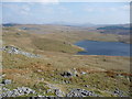
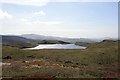
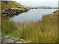
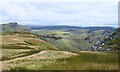
"a hut circle in a raised position above the NW end of Llyn Morwynion, bound by a stream on the NE side and in a lee of higher ground to the SW, protecting it from prevailing winds. It survives as a circular earthwork 6m in diameter, with stonework surviving up to 2 courses high and a pronounced rim in places."
My visit on the 7th Jan 2023 ended in a bit of a 'chin rub'. I'm confident that I eventually found the site, given the grid ref, and my observations do not differ greatly from the description given by Coflein. However, having taken a few photos I wandered up the sloping ground a few metres and discovered a second platform that could, arguably, be a similar platform to that apparent at the grid ref? Anyway, I've taken a longshot of the area and red arrowed the two sites. NB: the Coflein site is the lower of the two 😊
There are several further hut circle sites just a few metres lower in the valley and within Llyn Morwynion reservoir. Llyn Morwynion is situated in a vast moorland area known as Y Migneint, a rich prehistoric and more modern historical environment.
You may be viewing yesterday's version of this page. To see the most up to date information please register for a free account.
")
")
")
")
Do not use the above information on other web sites or publications without permission of the contributor.
Nearby Images from Geograph Britain and Ireland:
©2010(licence)
©2014(licence)
©2009(licence)
©2013(licence)
©2023(licence)
The above images may not be of the site on this page, they are loaded from Geograph.
Please Submit an Image of this site or go out and take one for us!
Click here to see more info for this site
Nearby sites
Key: Red: member's photo, Blue: 3rd party photo, Yellow: other image, Green: no photo - please go there and take one, Grey: site destroyed
Download sites to:
KML (Google Earth)
GPX (GPS waypoints)
CSV (Garmin/Navman)
CSV (Excel)
To unlock full downloads you need to sign up as a Contributory Member. Otherwise downloads are limited to 50 sites.
Turn off the page maps and other distractions
Nearby sites listing. In the following links * = Image available
102m S 186° Llyn Morwynion Hut Circle Settlement* Ancient Village or Settlement (SH7372542594)
204m SSE 161° Llyn Morwynion hut circle* Ancient Village or Settlement (SH738425)
612m NE 47° Y Garnedd cairn* Cairn (SH742431)
890m WNW 289° Bryn Y Castell hut circle* Ancient Village or Settlement (SH729430)
963m WNW 285° Bryn y Castell* Hillfort (SH7281342969)
979m NW 314° Gamallt Estate hut circle viii* Ancient Village or Settlement (SH7305043393)
983m NW 317° Gamallt Estate Stones* Standing Stones (SH7308743433)
996m SSE 156° Rhaeadr y Cwm Hut Circle* Ancient Village or Settlement (SH7411741772)
1.0km SE 142° Pont Yr Afon Hut Circle* Ancient Village or Settlement (SH7434241885)
1.0km NNW 331° Gamallt Hut Circle east* Ancient Village or Settlement (SH7327843594)
1.0km NW 304° Sarn Helen Roman Military Road at Cwm Gamallt* Ancient Trackway (SH729433)
1.0km NW 323° Afon Gamallt Hut Circle west* Ancient Village or Settlement (SH7313543535)
1.0km N 350° Afon Gamallt Hut Circles and Enclosure* Ancient Village or Settlement (SH7359243730)
1.1km SE 126° Llyn Dubach Hut Circle* Ancient Village or Settlement (SH7458642048)
1.2km NNW 341° Gamallt Iron Age Settlement* Ancient Village or Settlement (SH734438)
1.2km W 269° Cantiorix Lies Here* Early Christian Sculptured Stone (SH725427)
1.4km W 261° Beddau Gwyr Ardudwy* Artificial Mound (SH723425)
1.5km N 357° Gamallt hut circles* Ancient Village or Settlement (SH737442)
1.5km WSW 249° Sarn Helen Mound* Artificial Mound (SH723422)
1.6km NW 319° Cwm Teigl Hut Circle* Ancient Village or Settlement (SH7273543921)
1.8km NW 326° Cwm Teigl Settlement* Ancient Village or Settlement (SH7278244175)
2.0km WNW 286° Cwm Teigl Stones* Stone Row / Alignment (SH718433)
2.4km NW 324° Manod Mawr Shelter Modern Stone Circle etc (SH7239544666)
2.6km WNW 294° Settlement South of Manod Bach* Ancient Village or Settlement (SH714438)
2.7km ENE 66° Ffynnon Eidda* Holy Well or Sacred Spring (SH762437)
View more nearby sites and additional images


 We would like to know more about this location. Please feel free to add a brief description and any relevant information in your own language.
 Wir möchten mehr über diese Stätte erfahren. Bitte zögern Sie nicht, eine kurze Beschreibung und relevante Informationen in Deutsch hinzuzufügen.
 Nous aimerions en savoir encore un peu sur les lieux. S'il vous plaît n'hesitez pas à ajouter une courte description et tous les renseignements pertinents dans votre propre langue.
 Quisieramos informarnos un poco más de las lugares. No dude en añadir una breve descripción y otros datos relevantes en su propio idioma.