<< Our Photo Pages >> Grodzisko Myślibórz - Hillfort in Poland in Zachodniopomorskie
Submitted by marasch on Tuesday, 19 April 2011 Page Views: 4968
Iron Age and Later PrehistorySite Name: Grodzisko Myślibórz Alternative Name: Łysa GóraCountry: Poland
NOTE: This site is 41.387 km away from the location you searched for.
Voivodeship: Zachodniopomorskie Type: Hillfort
Nearest Town: Myślibórz Nearest Village: Myślibórz
Latitude: 52.939458N Longitude: 14.878506E
Condition:
| 5 | Perfect |
| 4 | Almost Perfect |
| 3 | Reasonable but with some damage |
| 2 | Ruined but still recognisable as an ancient site |
| 1 | Pretty much destroyed, possibly visible as crop marks |
| 0 | No data. |
| -1 | Completely destroyed |
| 5 | Superb |
| 4 | Good |
| 3 | Ordinary |
| 2 | Not Good |
| 1 | Awful |
| 0 | No data. |
| 5 | Can be driven to, probably with disabled access |
| 4 | Short walk on a footpath |
| 3 | Requiring a bit more of a walk |
| 2 | A long walk |
| 1 | In the middle of nowhere, a nightmare to find |
| 0 | No data. |
| 5 | co-ordinates taken by GPS or official recorded co-ordinates |
| 4 | co-ordinates scaled from a detailed map |
| 3 | co-ordinates scaled from a bad map |
| 2 | co-ordinates of the nearest village |
| 1 | co-ordinates of the nearest town |
| 0 | no data |
Internal Links:
External Links:
")
Large fortress built at the end of the 6th century BC century BC (end of the Bronze Age and beginning of Iron Age Hallstatt period) by the population of the Lusatian culture.
For centuries, maybe millennia, the hillfort sheltered people during enemy invasions.
It has an oval shape and is probably the oldest part of Myślibórz. Located 1.5 kilometers north of the city center, adjacent to the east of the Gulf Ptasia of Myślibórz Lake.
The central axis of oval fort is about 140 meters long and is oriented meridionally.
The width is about 65 meters. The pre-existing hill was widdened by wooden and earthen walls and a wooden stockade. Even today it stands about 6 meters above the fields to the east and to the west it is up to 12 meters above the water level of a lake Myślibórz, which is only 50 Meters away.
Later the Pomeranian inhabitants built an early medieval castle dated to the years 870 - 973/979.
When Mieszko I founded the Polish state at the end of the 10th century CE, the settlement expanded again.
The earth, wood and stone defensive structures no longer met the defense needs of the 12th/13th century, after which the Hilflort was abandoned.
It was used again during World War II, as evidenced today by traces of trenches.
Systematic archaeological research was began in World War II by German archaeologist H. Heiligendorff, but information about research findings probably did not survive. After the war, archaeological research was conducted in June 1958 by W. Szafranski. The results were published in a work entitled. "Studies in Grodzisko Mysliborz in Western Pomerania." They show the existence of a settlement of the Lusatian culture.
Today, the 2,500 years history of the settlement is an interesting site for suburban walks. It is an excellent vantage point.
You may be viewing yesterday's version of this page. To see the most up to date information please register for a free account.
")
")
")
Do not use the above information on other web sites or publications without permission of the contributor.
Nearby Images from Flickr
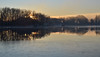
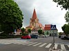
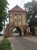
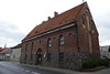
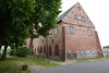

The above images may not be of the site on this page, but were taken nearby. They are loaded from Flickr so please click on them for image credits.
Click here to see more info for this site
Nearby sites
Click here to view sites on an interactive map of the areaKey: Red: member's photo, Blue: 3rd party photo, Yellow: other image, Green: no photo - please go there and take one, Grey: site destroyed
Download sites to:
KML (Google Earth)
GPX (GPS waypoints)
CSV (Garmin/Navman)
CSV (Excel)
To unlock full downloads you need to sign up as a Contributory Member. Otherwise downloads are limited to 50 sites.
Turn off the page maps and other distractions
Nearby sites listing. In the following links * = Image available
8.8km SW 227° Czarci Głaz Natural Stone / Erratic / Other Natural Feature
9.0km SW 228° Rościn Chambered Tombs* Chambered Tomb
19.5km SW 225° Grodzisko Smoliniec* Hillfort
20.3km NNE 28° Myśliborki Chambered Tombs Chambered Tomb
20.7km NNE 21° Letnin Chambered Tomb 3 Chambered Tomb
20.7km NNE 21° Letnin Chambered Tomb 4 Chambered Tomb
20.7km NNE 21° Letnin Chambered Tomb 2 Chambered Tomb
20.8km NNE 21° Letnin Chambered Tomb 1 Chambered Tomb
20.8km NNE 22° Letnin Chambered Tombs 5 – 10 Chambered Tomb
22.1km NNE 24° Brzesko Dolmen 1 Chambered Tomb
22.1km NNE 23° Brzesko Dolmen 5 Chambered Tomb
22.1km NNE 23° Brzesko Dolmen 4 Chambered Tomb
22.2km NNE 23° Brzesko Dolmen 3 Chambered Tomb
22.2km NNE 23° Brzesko Dolmen 2 Chambered Tomb
22.2km NNE 24° Brzesko Dolmen 7 Chambered Tomb
22.2km NNE 24° Brzesko Dolmen 6 Chambered Tomb
22.4km NE 36° Przelewice Chambered Tomb 8 Chambered Tomb
22.4km NE 37° Przelewice Chambered Tomb 5 Chambered Tomb
22.4km NE 36° Przelewice Chambered Tomb 7 Chambered Tomb
22.5km NE 37° Przelewice Chambered Tomb 4 Chambered Tomb
22.5km NE 36° Przelewice Chambered Tomb 6 Chambered Tomb
22.5km NE 36° Przelewice Chambered Tomb 3 Chambered Tomb
22.5km NE 37° Przelewice Chambered Tomb 1 Chambered Tomb
22.5km NE 36° Przelewice Chambered Tomb 2 Chambered Tomb
23.7km NNE 30° Kosin Chambered Tombs Chambered Tomb
View more nearby sites and additional images


 We would like to know more about this location. Please feel free to add a brief description and any relevant information in your own language.
 Wir möchten mehr über diese Stätte erfahren. Bitte zögern Sie nicht, eine kurze Beschreibung und relevante Informationen in Deutsch hinzuzufügen.
 Nous aimerions en savoir encore un peu sur les lieux. S'il vous plaît n'hesitez pas à ajouter une courte description et tous les renseignements pertinents dans votre propre langue.
 Quisieramos informarnos un poco más de las lugares. No dude en añadir una breve descripción y otros datos relevantes en su propio idioma.