<< Our Photo Pages >> Kilmogue portal tomb - Portal Tomb in Ireland (Republic of) in Co. Kilkenny
Submitted by Anthony_Weir on Sunday, 13 October 2002 Page Views: 6924
Neolithic and Bronze AgeSite Name: Kilmogue portal tomb Alternative Name: Leac an Scáil, The tomb of the warrior, Leach NaScail, Harristown DolmenCountry: Ireland (Republic of)
NOTE: This site is 10.308 km away from the location you searched for.
County: Co. Kilkenny Type: Portal Tomb
Nearest Town: Carrick-on-Suir Nearest Village: Harristown
Discovery Map Number: D75
Latitude: 52.403110N Longitude: 7.2623W
Condition:
| 5 | Perfect |
| 4 | Almost Perfect |
| 3 | Reasonable but with some damage |
| 2 | Ruined but still recognisable as an ancient site |
| 1 | Pretty much destroyed, possibly visible as crop marks |
| 0 | No data. |
| -1 | Completely destroyed |
| 5 | Superb |
| 4 | Good |
| 3 | Ordinary |
| 2 | Not Good |
| 1 | Awful |
| 0 | No data. |
| 5 | Can be driven to, probably with disabled access |
| 4 | Short walk on a footpath |
| 3 | Requiring a bit more of a walk |
| 2 | A long walk |
| 1 | In the middle of nowhere, a nightmare to find |
| 0 | No data. |
| 5 | co-ordinates taken by GPS or official recorded co-ordinates |
| 4 | co-ordinates scaled from a detailed map |
| 3 | co-ordinates scaled from a bad map |
| 2 | co-ordinates of the nearest village |
| 1 | co-ordinates of the nearest town |
| 0 | no data |
Internal Links:
External Links:
I have visited· I would like to visit
mark_a has visited here
")
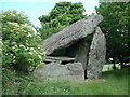
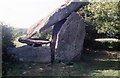
Up a farm lane and across a field to the N. this fine dolmen is hidden in a hollow and surrounded by bushes. Its portal-stones are 3.6 metres high, framing a fine door-stone 2.7 metres high.
The dramatically-tilted capstone projects beyond the portal and reaches a height of 4.5 metres. Its lower end rests on a smaller, horizontal stone which partly covers the chamber. Traces of cairn survive round about.
~ 3.2 km SW in Garryduff, immediately W of a crossroads 2.4 km NE of Owning is “The Long Stone”, a menhir nearly 3.5 metres high.
~ 20 kms due E, only 2.4 kms W of New Ross, 400metres up a tarred lane to the NW of a by-road leading to Mullinavat – then 400 metres up a grassy track to an abandoned farm, and then across two fields is another another impressive portal-tomb in Glencloghlea (S 698273). The capstone is 3 x 2.4 metres and 1.5 metres thick, and is supported by one slab-like portal-stone 1.5 metres high, and a door-stone. The backstone has collapsed.
You may be viewing yesterday's version of this page. To see the most up to date information please register for a free account.
")
")
Do not use the above information on other web sites or publications without permission of the contributor.
Nearby Images from Geograph Britain and Ireland:
©2006(licence)
©2019(licence)
©2019(licence)
The above images may not be of the site on this page, they are loaded from Geograph.
Please Submit an Image of this site or go out and take one for us!
Click here to see more info for this site
Nearby sites
Click here to view sites on an interactive map of the areaKey: Red: member's photo, Blue: 3rd party photo, Yellow: other image, Green: no photo - please go there and take one, Grey: site destroyed
Download sites to:
KML (Google Earth)
GPX (GPS waypoints)
CSV (Garmin/Navman)
CSV (Excel)
To unlock full downloads you need to sign up as a Contributory Member. Otherwise downloads are limited to 50 sites.
Turn off the page maps and other distractions
Nearby sites listing. In the following links * = Image available
101m WSW 257° Kilmogue standing stone Standing Stone (Menhir)
7.2km W 272° Baunfree* Passage Grave
9.0km W 277° The Cross of Ages (Kilclispeen)* Ancient Cross (S413291)
9.9km WNW 289° Knockroe* Passage Grave (S40863126)
10.3km E 93° Three Friars* Stone Row / Alignment
12.8km N 358° Kilree Monastery* Ancient Cross
13.5km SW 223° Ballyquin* Portal Tomb (S411182)
13.9km NNE 29° St Nicholas's Grave (Newtown Jerpoint) Early Christian Sculptured Stone (S56794042)
14.8km WNW 303° Killamery High Cross Ancient Cross (S377361)
19.5km E 93° Glencloghlea* Portal Tomb (S698273)
22.1km ENE 58° Brandon Hill Stone Circle (S690400)
22.2km S 171° Gaulstown Portal Dolmen* Burial Chamber or Dolmen
22.3km ESE 112° Whitechurch Standing Stone Standing Stone (Menhir)
22.6km ESE 114° Whitechurch Stone Circle (S710190)
22.8km ESE 115° Whitechurch Stone Row / Alignment
22.8km SSE 162° Knockeen Portal Tomb* Portal Tomb (S575065)
24.5km ENE 67° St. Mullin's Motte and Bailey* Ancient Village or Settlement
25.1km S 182° Ballinageeragh* Portal Tomb
25.5km S 175° Matthewstown* Passage Grave (S528028)
29.8km SE 145° Harristown* Passage Grave (S677040)
30.1km SSW 207° Drumlohan* Standing Stone (Menhir) (S367013)
30.5km WSW 238° Tooreen W Stone Row / Alignment (S245117)
30.7km E 89° Robinstown Great* Stone Circle (S8104629049)
31.9km E 98° Carrickbyrne Stone Circle (S820240)
32.0km SSE 156° Coolum Promontory Stone Fort or Dun
View more nearby sites and additional images


 We would like to know more about this location. Please feel free to add a brief description and any relevant information in your own language.
 Wir möchten mehr über diese Stätte erfahren. Bitte zögern Sie nicht, eine kurze Beschreibung und relevante Informationen in Deutsch hinzuzufügen.
 Nous aimerions en savoir encore un peu sur les lieux. S'il vous plaît n'hesitez pas à ajouter une courte description et tous les renseignements pertinents dans votre propre langue.
 Quisieramos informarnos un poco más de las lugares. No dude en añadir una breve descripción y otros datos relevantes en su propio idioma.