<< Our Photo Pages >> Ffynnondruidion - Chambered Tomb in Wales in Pembrokeshire
Submitted by marcusb2000 on Saturday, 26 April 2003 Page Views: 6433
Neolithic and Bronze AgeSite Name: FfynnondruidionCountry: Wales
NOTE: This site is 1.183 km away from the location you searched for.
County: Pembrokeshire Type: Chambered Tomb
Nearest Town: Fishguard Nearest Village: St Nicholas
Map Ref: SM920368 Landranger Map Number: 157
Latitude: 51.990598N Longitude: 5.030865W
Condition:
| 5 | Perfect |
| 4 | Almost Perfect |
| 3 | Reasonable but with some damage |
| 2 | Ruined but still recognisable as an ancient site |
| 1 | Pretty much destroyed, possibly visible as crop marks |
| 0 | No data. |
| -1 | Completely destroyed |
| 5 | Superb |
| 4 | Good |
| 3 | Ordinary |
| 2 | Not Good |
| 1 | Awful |
| 0 | No data. |
| 5 | Can be driven to, probably with disabled access |
| 4 | Short walk on a footpath |
| 3 | Requiring a bit more of a walk |
| 2 | A long walk |
| 1 | In the middle of nowhere, a nightmare to find |
| 0 | No data. |
| 5 | co-ordinates taken by GPS or official recorded co-ordinates |
| 4 | co-ordinates scaled from a detailed map |
| 3 | co-ordinates scaled from a bad map |
| 2 | co-ordinates of the nearest village |
| 1 | co-ordinates of the nearest town |
| 0 | no data |
Internal Links:
External Links:
")
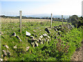
This was destroyed at the turn of the century, but the whole area is littered with natural outcrops of rock. A field further down the road has a standing stone that may be related, but it may also be a cattle scratching post of relatively recent date. A natural spring lies nearby which may be of some religious significance. The name of the tomb literally means 'stone of the heroes' (not druids).
You may be viewing yesterday's version of this page. To see the most up to date information please register for a free account.
")
Do not use the above information on other web sites or publications without permission of the contributor.
Nearby Images from Geograph Britain and Ireland:
©2017(licence)
©2008(licence)
©2017(licence)
©2015(licence)
©2009(licence)
The above images may not be of the site on this page, they are loaded from Geograph.
Please Submit an Image of this site or go out and take one for us!
Click here to see more info for this site
Nearby sites
Key: Red: member's photo, Blue: 3rd party photo, Yellow: other image, Green: no photo - please go there and take one, Grey: site destroyed
Download sites to:
KML (Google Earth)
GPX (GPS waypoints)
CSV (Garmin/Navman)
CSV (Excel)
To unlock full downloads you need to sign up as a Contributory Member. Otherwise downloads are limited to 50 sites.
Turn off the page maps and other distractions
Nearby sites listing. In the following links * = Image available
316m SSE 159° Fynnon Drudion* Standing Stone (Menhir) (SM921365)
1.3km SSE 159° Penmeiddyn Stone Row / Alignment (SM9241535584)
1.5km ESE 120° Manorowen* Standing Stone (Menhir) (SM9324736021)
1.5km SSW 204° Rhos y Clegyrn* Stone Circle (SM9133035456)
2.2km SW 235° St Nicholas Stones* Early Christian Sculptured Stone (SM901356)
2.2km SW 235° St Nicholas Well (N Pembrokeshire)* Holy Well or Sacred Spring (SM901356)
2.3km NNW 328° Gilfach Farm Standing Stone* Standing Stone (Menhir) (SM90873880)
2.3km SW 214° Ffyst Samson* Chambered Tomb (SM90613491)
2.5km WNW 290° Castell Poeth Ancient Village or Settlement (SM89723773)
2.5km NNW 331° Garn Gilfach.* Rock Cut Tomb (SM909390)
2.5km NNE 27° Carn Wnda Standing Stone* Standing Stone (Menhir) (SM9327239010)
2.7km NNW 331° Garn Gilfach Standing Stone* Standing Stone (Menhir) (SM90803920)
2.8km NNE 26° Carn Wnda.* Chambered Tomb (SM93313923)
2.8km W 265° Castell Bach (Pencaer) Hillfort (SM89193666)
2.9km NNW 344° Trenewydd well* Holy Well or Sacred Spring (SM913396)
2.9km NW 315° Garn Fechan* Hillfort (SM90043893)
3.0km NNE 21° Ffynnon Wnda* Holy Well or Sacred Spring (SM9317939536)
3.0km NW 306° Ysgubor Gaer Hillfort (SM89623865)
3.0km NNE 21° St Gwyndaf Stones* Early Christian Sculptured Stone (SM932396)
3.1km S 176° Castell Hendre-Wen Ancient Village or Settlement (SM92083370)
3.1km NW 308° Garn Fawr (Pembrokeshire)* Hillfort (SM89613882)
3.2km NE 42° Parc-y-Cromlech* Chambered Tomb (SM94223907)
3.6km NE 49° Garn Wen 1* Chambered Tomb (SM94813904)
3.6km NE 48° Garn Wen 2* Chambered Tomb (SM94803910)
3.7km NE 47° Garn Wen 3* Chambered Tomb (SM94803920)
View more nearby sites and additional images


 We would like to know more about this location. Please feel free to add a brief description and any relevant information in your own language.
 Wir möchten mehr über diese Stätte erfahren. Bitte zögern Sie nicht, eine kurze Beschreibung und relevante Informationen in Deutsch hinzuzufügen.
 Nous aimerions en savoir encore un peu sur les lieux. S'il vous plaît n'hesitez pas à ajouter une courte description et tous les renseignements pertinents dans votre propre langue.
 Quisieramos informarnos un poco más de las lugares. No dude en añadir una breve descripción y otros datos relevantes en su propio idioma.