<< Our Photo Pages >> Glanleam standing stone - Standing Stone (Menhir) in Ireland (Republic of) in Co. Kerry
Submitted by GaelicLaird on Tuesday, 12 January 2021 Page Views: 1868
Neolithic and Bronze AgeSite Name: Glanleam standing stoneCountry: Ireland (Republic of)
NOTE: This site is 2.393 km away from the location you searched for.
County: Co. Kerry Type: Standing Stone (Menhir)
Nearest Town: Knight's Town
Latitude: 51.932306N Longitude: 10.32217W
Condition:
| 5 | Perfect |
| 4 | Almost Perfect |
| 3 | Reasonable but with some damage |
| 2 | Ruined but still recognisable as an ancient site |
| 1 | Pretty much destroyed, possibly visible as crop marks |
| 0 | No data. |
| -1 | Completely destroyed |
| 5 | Superb |
| 4 | Good |
| 3 | Ordinary |
| 2 | Not Good |
| 1 | Awful |
| 0 | No data. |
| 5 | Can be driven to, probably with disabled access |
| 4 | Short walk on a footpath |
| 3 | Requiring a bit more of a walk |
| 2 | A long walk |
| 1 | In the middle of nowhere, a nightmare to find |
| 0 | No data. |
| 5 | co-ordinates taken by GPS or official recorded co-ordinates |
| 4 | co-ordinates scaled from a detailed map |
| 3 | co-ordinates scaled from a bad map |
| 2 | co-ordinates of the nearest village |
| 1 | co-ordinates of the nearest town |
| 0 | no data |
Internal Links:
External Links:
")
Officially recorded as monument KE079-055002
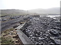
The standing stone (KE079-055002-) is of approximately rectangular elevation and stands 3.43m in maximum height. It is roughly trapezoidal in plan at base, measuring 1.43m x .34m; NE-SW. It averages .4m thick. A number of packing stones are visible around its base, and a slab, 1.5m long, leans against its SE face. At present the monument is upright, though Chatterton noted that it was then 'very easily shaken' (1839, 265), an observation which may explain the presence of the supporting slab.
The above description is derived from A. O'Sullivan and J. Sheehan (compilers), 'The Iveragh peninsula: an archaeological survey of South Kerry'. Cork University Press (1996), no. 1454.
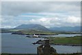
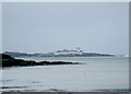
The stone is located within the walls of Cromwell Fort (monument no KE079-055001). The lighthouse shown in the photo is opened to the public and worth a visit.
You may be viewing yesterday's version of this page. To see the most up to date information please register for a free account.
")
Do not use the above information on other web sites or publications without permission of the contributor.
Nearby Images from Geograph Britain and Ireland:
©2009(licence)
©2014(licence)
©2009(licence)

©2008(licence)

©2015(licence)
The above images may not be of the site on this page, they are loaded from Geograph.
Please Submit an Image of this site or go out and take one for us!
Click here to see more info for this site
Nearby sites
Click here to view sites on an interactive map of the areaKey: Red: member's photo, Blue: 3rd party photo, Yellow: other image, Green: no photo - please go there and take one, Grey: site destroyed
Download sites to:
KML (Google Earth)
GPX (GPS waypoints)
CSV (Garmin/Navman)
CSV (Excel)
To unlock full downloads you need to sign up as a Contributory Member. Otherwise downloads are limited to 50 sites.
Turn off the page maps and other distractions
Nearby sites listing. In the following links * = Image available
2.6km WSW 244° Tinnies Upper Stone Circle (V380770)
3.2km ENE 62° Ballycarbery west wedge tomb* Wedge Tomb
3.5km SW 229° Cool East wedge tomb* Wedge Tomb
3.6km NE 42° Doulus Head Hut Sites* Ancient Village or Settlement
3.9km SW 227° Cool East ogham stone* Standing Stone (Menhir)
5.1km ENE 59° Cahergal* Stone Fort or Dun (V4484180557)
5.2km NE 53° Leacanabuaile* Stone Fort or Dun (V4463781059)
5.4km ENE 58° Kimego Standing Stones (V450808)
5.8km WSW 245° St Brendan's Well* Holy Well or Sacred Spring
6.5km E 80° Cahersiveen standing stones* Standing Stones (V4674478981)
7.5km SE 137° Fermoyle Stone Row / Alignment (V453724)
8.6km S 180° St Buonia's Cross (Killabuonia) Early Christian Sculptured Stone (V4002269422)
9.1km S 174° Leabaleaha Stone Circle (V410690)
10.1km E 93° Canburrin Standing Stones
12.1km S 177° Coom Wedge Tomb* Wedge Tomb
12.4km E 80° Srugreana Standing Stone (Menhir)
13.3km ENE 71° Ballynahow Beg* Rock Art (V5305682093)
14.0km SE 140° Spuncane Stone Circle (V490670)
14.4km S 176° Kildreelig* Stone Row / Alignment
15.1km S 181° Bolus Standing Stones (V396630)
15.2km ENE 63° Kells Modern Stone Circle* Modern Stone Circle etc (V5413584497)
15.2km ENE 67° Garrydine Standing Stones
15.8km ESE 115° Doory row Stone Row / Alignment
15.9km ESE 115° Doory standing stone Standing Stone (Menhir)
16.6km ESE 120° Dromod* Stone Circle (V545694)
View more nearby sites and additional images


 We would like to know more about this location. Please feel free to add a brief description and any relevant information in your own language.
 Wir möchten mehr über diese Stätte erfahren. Bitte zögern Sie nicht, eine kurze Beschreibung und relevante Informationen in Deutsch hinzuzufügen.
 Nous aimerions en savoir encore un peu sur les lieux. S'il vous plaît n'hesitez pas à ajouter une courte description et tous les renseignements pertinents dans votre propre langue.
 Quisieramos informarnos un poco más de las lugares. No dude en añadir una breve descripción y otros datos relevantes en su propio idioma.