<< Our Photo Pages >> Rostellan - Portal Tomb in Ireland (Republic of) in Co. Cork
Submitted by Andy B on Wednesday, 15 February 2017 Page Views: 3316
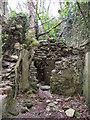
Neolithic and Bronze AgeSite Name: Rostellan Alternative Name: Carraig á Mhaistin dolmenCountry: Ireland (Republic of)
NOTE: This site is 9.883 km away from the location you searched for.
County: Co. Cork Type: Portal Tomb
Nearest Village: Midleton
Map Ref: W8746267180
Latitude: 51.857248N Longitude: 8.182703W
Condition:
| 5 | Perfect |
| 4 | Almost Perfect |
| 3 | Reasonable but with some damage |
| 2 | Ruined but still recognisable as an ancient site |
| 1 | Pretty much destroyed, possibly visible as crop marks |
| 0 | No data. |
| -1 | Completely destroyed |
| 5 | Superb |
| 4 | Good |
| 3 | Ordinary |
| 2 | Not Good |
| 1 | Awful |
| 0 | No data. |
| 5 | Can be driven to, probably with disabled access |
| 4 | Short walk on a footpath |
| 3 | Requiring a bit more of a walk |
| 2 | A long walk |
| 1 | In the middle of nowhere, a nightmare to find |
| 0 | No data. |
| 5 | co-ordinates taken by GPS or official recorded co-ordinates |
| 4 | co-ordinates scaled from a detailed map |
| 3 | co-ordinates scaled from a bad map |
| 2 | co-ordinates of the nearest village |
| 1 | co-ordinates of the nearest town |
| 0 | no data |
Internal Links:
External Links:
I have visited· I would like to visit
Gallain_Asters would like to visit
mark_a has visited here
")
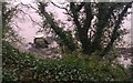
A dolmen in the river and only accessible at low tide!
You may be viewing yesterday's version of this page. To see the most up to date information please register for a free account.
Do not use the above information on other web sites or publications without permission of the contributor.
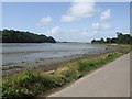
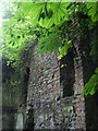
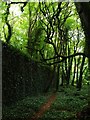
Nearby Images from Geograph Britain and Ireland:
©2013(licence)
©2009(licence)
©2012(licence)
©2012(licence)
©2012(licence)
The above images may not be of the site on this page, they are loaded from Geograph.
Please Submit an Image of this site or go out and take one for us!
Click here to see more info for this site
Nearby sites
Click here to view sites on an interactive map of the areaKey: Red: member's photo, Blue: 3rd party photo, Yellow: other image, Green: no photo - please go there and take one, Grey: site destroyed
Download sites to:
KML (Google Earth)
GPX (GPS waypoints)
CSV (Garmin/Navman)
CSV (Excel)
To unlock full downloads you need to sign up as a Contributory Member. Otherwise downloads are limited to 50 sites.
Turn off the page maps and other distractions
Nearby sites listing. In the following links * = Image available
17.3km NNW 337° Knockeennagrouagh* Standing Stones
17.8km W 266° Ballinvuskig standing stone (south)* Standing Stone (Menhir)
18.0km W 266° Ballinvuskig standing stone (north)* Standing Stone (Menhir)
18.4km N 9° Garryduff Stone Row Stone Row / Alignment (W904854)
19.7km N 357° Curraghdermot Stone Row / Alignment (W86648688)
20.0km WSW 247° Piercetown* Stone Row / Alignment (W690593)
20.7km WSW 257° Meadstown standing stone* Standing Stone (Menhir)
21.1km NW 314° Ballindeenisk Stone Row / Alignment (W723819)
21.5km NNW 331° Curraghroe Stone Circle (W770860)
21.6km W 281° University College Cork - Stone Corridor* Museum
21.8km WNW 282° Cork Public Museum* Museum
24.3km WNW 303° Ballyhesty Standing Stones
24.3km WNW 285° Killeens South standing stone* Standing Stone (Menhir)
24.5km WNW 286° Killeens North standing stone* Standing Stone (Menhir)
25.4km WNW 297° Ballinvarrig Standing Stones (W648789)
26.5km W 277° Carrigrohane north standing stone* Standing Stone (Menhir)
26.5km WNW 292° Curraghnalaght standing stone (south)* Standing Stone (Menhir)
26.5km WNW 292° Curraghnalaght standing stone (north)* Standing Stone (Menhir)
27.2km SW 225° Ballymacus megalithic tomb* Burial Chamber or Dolmen
27.3km SW 228° Clonleigh Standing Stone (Menhir) (W670490)
27.6km WNW 287° Blarney Dolmen* Natural Stone / Erratic / Other Natural Feature
27.7km SW 229° Clonleigh Boulder Burial* Burial Chamber or Dolmen
28.0km WNW 294° Ballygibbon* Standing Stones (W61757848)
29.2km WNW 301° Dromgarriff Stone Circle (W62338222)
30.5km W 279° Garravagh standing stone* Standing Stone (Menhir)
View more nearby sites and additional images


 We would like to know more about this location. Please feel free to add a brief description and any relevant information in your own language.
 Wir möchten mehr über diese Stätte erfahren. Bitte zögern Sie nicht, eine kurze Beschreibung und relevante Informationen in Deutsch hinzuzufügen.
 Nous aimerions en savoir encore un peu sur les lieux. S'il vous plaît n'hesitez pas à ajouter une courte description et tous les renseignements pertinents dans votre propre langue.
 Quisieramos informarnos un poco más de las lugares. No dude en añadir una breve descripción y otros datos relevantes en su propio idioma.