<< Our Photo Pages >> Red Well (Matson) - Holy Well or Sacred Spring in England in Gloucestershire
Submitted by 4clydesdale7 on Tuesday, 05 January 2010 Page Views: 8660
Springs and Holy WellsSite Name: Red Well (Matson) Alternative Name: Holy Red WellCountry: England County: Gloucestershire Type: Holy Well or Sacred Spring
Nearest Town: Gloucester Nearest Village: Matson
Map Ref: SO8479615289
Latitude: 51.836000N Longitude: 2.222062W
Condition:
| 5 | Perfect |
| 4 | Almost Perfect |
| 3 | Reasonable but with some damage |
| 2 | Ruined but still recognisable as an ancient site |
| 1 | Pretty much destroyed, possibly visible as crop marks |
| 0 | No data. |
| -1 | Completely destroyed |
| 5 | Superb |
| 4 | Good |
| 3 | Ordinary |
| 2 | Not Good |
| 1 | Awful |
| 0 | No data. |
| 5 | Can be driven to, probably with disabled access |
| 4 | Short walk on a footpath |
| 3 | Requiring a bit more of a walk |
| 2 | A long walk |
| 1 | In the middle of nowhere, a nightmare to find |
| 0 | No data. |
| 5 | co-ordinates taken by GPS or official recorded co-ordinates |
| 4 | co-ordinates scaled from a detailed map |
| 3 | co-ordinates scaled from a bad map |
| 2 | co-ordinates of the nearest village |
| 1 | co-ordinates of the nearest town |
| 0 | no data |
Internal Links:
External Links:
I have visited· I would like to visit
4clydesdale7 visited on 4th Sep 2011 - their rating: Cond: 3 Amb: 4 Access: 3 Well and nearby lake quite delightful - grey shed green railings and general area not so -
 (PID:81295)")
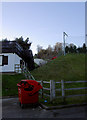
The siting of this Well on Pastscape is just a little inaccurate, which could cause problems on a visit because you cannot get to or see the Well directly from Matson Lane - driving S along Matson Lane you will first come across, on your left, the Hallmark Spa Hotel then on your right a row of houses followed by the entrance to the Dry Ski Slope - park in their carpark as near as you can to the entrance - then look N behind the houses you have just passed - you will see a fenced/padlocked gate area in which the Ski Slope jettison their rubbish and bits of artificial snow track.
You will need climbing skills to get over the gate/fence - having done so you will see a wide gap in a hedge on your left - go through that gap and turn immediately right walk for about 150m N and you will see the Well (or its obligatory HSE high green railings designed to impale any intruder seeking to use the Well) - the big surprise is a little beyond - a rather delightful and picturesque pond/lake - ignore the rather ugly grey shed - apart from the old village of Matson the neighbourhood is 'less than inviting' - anything not nailed to the ground has a tendency to wander (a bit like a certain Longstone?!) - lock your car - still it is worth at least one visit for the Well/Lake alone
From Pastscape:
"The Red Well at Matson consists of a 3ft. square limestone trough at the road-side, fed from a chalybeate spring in the field a few yards above it. The interior of the trough is 2ft. square by 1ft. deep, and its overflow is fed through a gargoyle into a semi-circular basin on the east side. Nearby are the remains of stones, which, if placed round the well, would give it the form of a Maltese cross. The spring belonged to the Canons of Llanthony, and its history dates from 1066, when Ralph de Mattesdon gave the church of Mattesdon to St. Peter's Abbey Gloucester."
http://www.pastscape.org.uk/hob.aspx?hob_id=115297
You may be viewing yesterday's version of this page. To see the most up to date information please register for a free account.
 (PID:37084)")
Do not use the above information on other web sites or publications without permission of the contributor.
Nearby Images from Geograph Britain and Ireland:
©2007(licence)

©2013(licence)

©2023(licence)

©2023(licence)
©2007(licence)
The above images may not be of the site on this page, they are loaded from Geograph.
Please Submit an Image of this site or go out and take one for us!
Click here to see more info for this site
Nearby sites
Key: Red: member's photo, Blue: 3rd party photo, Yellow: other image, Green: no photo - please go there and take one, Grey: site destroyed
Download sites to:
KML (Google Earth)
GPX (GPS waypoints)
CSV (Garmin/Navman)
CSV (Excel)
To unlock full downloads you need to sign up as a Contributory Member. Otherwise downloads are limited to 50 sites.
Turn off the page maps and other distractions
Nearby sites listing. In the following links * = Image available
752m WSW 247° Robins Wood Hill Standing Stones (SO841150)
856m WNW 292° Well House (Gloucester)* Holy Well or Sacred Spring (SO84001561)
3.0km SSE 164° King Charles Stone* Marker Stone (SO856124)
3.8km WNW 301° Hempsted Camp* Hillfort (SO81551725)
3.8km SSE 146° Painswick Beacon* Hillfort (SO869121)
3.9km WNW 301° Lady's Well (Gloucestershire)* Holy Well or Sacred Spring (SO815173)
4.3km ESE 120° Cranham Corner Earthworks* Misc. Earthwork (SO88501313)
4.6km ESE 109° High Brotheridge* Misc. Earthwork (SO89121381)
4.9km NE 42° Churchdown Hill Camp* Hillfort (SO881189)
5.1km ESE 105° Tile Well* Holy Well or Sacred Spring (SO89721395)
5.7km ENE 67° Badgeworth Round Barrow* Round Barrow(s) (SO90071750)
5.8km SSE 155° Washwell* Holy Well or Sacred Spring (SO872100)
6.0km SSE 160° St Tibby's Well* Holy Well or Sacred Spring (SO86880961)
6.1km SSW 195° Cliff Well* Holy Well or Sacred Spring (SO83240944)
6.1km SE 140° Holy well (Sheepscombe) Holy Well or Sacred Spring (SO887106)
6.6km ESE 108° West Tump* Long Barrow (SO9112213241)
6.8km SSW 201° Haresfield Beacon and Ring* Hillfort (SO823090)
6.8km S 191° Haresfield Barrow* Round Barrow(s) (SO83500862)
6.8km S 191° Haresfield Dyke Camp* Ancient Village or Settlement (SO83500862)
7.0km SSW 203° Haresfield Beacon tumulus* Round Barrow(s) (SO82030887)
7.0km ESE 112° Bucks Head Round Barrow* Round Barrow(s) (SO91321260)
7.3km SSW 197° Shortwood Barrows* Round Barrow(s) (SO82670831)
7.6km E 94° Birdlip standing stones* Modern Stone Circle etc (SO9235214746)
7.6km E 92° Birdlip Camp* Hillfort (SO924150)
7.6km ESE 116° Climperwell Round Barrows* Round Barrow(s) (SO91641196)
View more nearby sites and additional images


 We would like to know more about this location. Please feel free to add a brief description and any relevant information in your own language.
 Wir möchten mehr über diese Stätte erfahren. Bitte zögern Sie nicht, eine kurze Beschreibung und relevante Informationen in Deutsch hinzuzufügen.
 Nous aimerions en savoir encore un peu sur les lieux. S'il vous plaît n'hesitez pas à ajouter une courte description et tous les renseignements pertinents dans votre propre langue.
 Quisieramos informarnos un poco más de las lugares. No dude en añadir una breve descripción y otros datos relevantes en su propio idioma.