<< Text Pages >> Mynydd Pysgodlyn Cairn - Cairn in Wales in West Glamorgan
Submitted by coldrum on Saturday, 02 July 2011 Page Views: 5265
Neolithic and Bronze AgeSite Name: Mynydd Pysgodlyn CairnCountry: Wales County: West Glamorgan Type: Cairn
Map Ref: SN63400475
Latitude: 51.724782N Longitude: 3.979116W
Condition:
| 5 | Perfect |
| 4 | Almost Perfect |
| 3 | Reasonable but with some damage |
| 2 | Ruined but still recognisable as an ancient site |
| 1 | Pretty much destroyed, possibly visible as crop marks |
| 0 | No data. |
| -1 | Completely destroyed |
| 5 | Superb |
| 4 | Good |
| 3 | Ordinary |
| 2 | Not Good |
| 1 | Awful |
| 0 | No data. |
| 5 | Can be driven to, probably with disabled access |
| 4 | Short walk on a footpath |
| 3 | Requiring a bit more of a walk |
| 2 | A long walk |
| 1 | In the middle of nowhere, a nightmare to find |
| 0 | No data. |
| 5 | co-ordinates taken by GPS or official recorded co-ordinates |
| 4 | co-ordinates scaled from a detailed map |
| 3 | co-ordinates scaled from a bad map |
| 2 | co-ordinates of the nearest village |
| 1 | co-ordinates of the nearest town |
| 0 | no data |
Be the first person to rate this site - see the 'Contribute!' box in the right hand menu.
Internal Links:
External Links:
Cairn in West Glamorgan
Coflein entry.
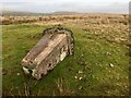
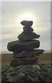
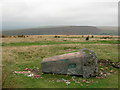
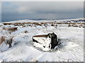
"A cairn is situated on the summit of Mynydd Pysgodlyn at 260m above OD.
It measures 7.5m (N-S) by 5.3m and consists of small angular stones consolidated with grasses. The mound has a dished appearance, probably the result of robbing from the north side where the rim of the 'dish' is lowest. Its maximum height is about 0.4m, on the south.
A discarded OS trig point lies to the south, possibly the cause of the mound's disturbance, and what has been recorded may be the most visible remnants of a larger mound some 10m across."
https://www.coflein.gov.uk/en/site/91844 />
You may be viewing yesterday's version of this page. To see the most up to date information please register for a free account.
Do not use the above information on other web sites or publications without permission of the contributor.
Nearby Images from Geograph Britain and Ireland:
©2018(licence)
©2018(licence)
©2018(licence)
©2013(licence)
©2020(licence)
The above images may not be of the site on this page, they are loaded from Geograph.
Please Submit an Image of this site or go out and take one for us!
Click here to see more info for this site
Nearby sites
Key: Red: member's photo, Blue: 3rd party photo, Yellow: other image, Green: no photo - please go there and take one, Grey: site destroyed
Download sites to:
KML (Google Earth)
GPX (GPS waypoints)
CSV (Garmin/Navman)
CSV (Excel)
To unlock full downloads you need to sign up as a Contributory Member. Otherwise downloads are limited to 50 sites.
Turn off the page maps and other distractions
Nearby sites listing. In the following links * = Image available
130m NE 56° Penlle'r Bebyll* Ring Cairn (SN63510482)
1.9km NNW 341° Graig Fawr Ring Cairn* Ring Cairn (SN628066)
2.6km N 351° Graig Fawr (East) Burnt Mound Misc. Earthwork (SN63080729)
2.6km N 349° Graig Fawr Burnt Mound Misc. Earthwork (SN63000728)
2.9km WNW 298° Graig Fawr* Chambered Tomb (SN60840620)
3.1km N 8° Blaenffynhonnau Hut Circle Ancient Village or Settlement (SN63900783)
3.7km NNE 16° Pentwyn Mawr Round Cairn (SN64530826)
5.8km NW 307° Bryn-Y-Rhyd* Standing Stone (Menhir) (SN5883008362)
6.3km E 79° Carn Llechart Megalithic Complex* Modern Stone Circle etc (SN69670576)
6.4km ENE 75° Carn Llechart Chambered Tomb* Chambered Tomb (SN69670627)
6.5km ENE 75° Carn Llechart Cairn Circle* Ring Cairn (SN69730627)
6.6km NNE 31° Henrhyd Cairns* Cairn (SN66991033)
6.8km NNE 30° Llech Yr Halen Marker Stone (SN670105)
7.2km SSE 158° Ffynnon Deml* Holy Well or Sacred Spring (SS65969798)
7.3km SSW 202° Carn Goch (West Glamorgan)* Cairn (SS605980)
7.5km NE 42° Bancbryn cairn cemetery* Barrow Cemetery (SN68631021)
7.6km NE 45° Bancbryn platform cairn* Cairn (SN68950998)
7.7km SW 215° Gorseinon Gorsedd Circle* Modern Stone Circle etc (SS5882998591)
7.7km NE 47° Llety'r-crydd cairn cemetery* Barrow Cemetery (SN69200991)
7.8km NE 43° Mynydd y Betws* Stone Row / Alignment (SN6893610326)
7.9km NNE 20° Bodyst Uchaf ring cairn* Ring Cairn (SN66281213)
8.1km N 355° Ammanford Gorsedd Stone Circle* Modern Stone Circle etc (SN62931282)
8.1km WNW 283° Brynmaen Standing Stone* Standing Stone (Menhir) (SN5552706764)
8.1km ENE 61° Nant-Y-Gaseg modern stone circle* Modern Stone Circle etc (SN7063408515)
8.1km NE 40° Plas-y-coed cairns* Barrow Cemetery (SN68771089)
View more nearby sites and additional images


 We would like to know more about this location. Please feel free to add a brief description and any relevant information in your own language.
 Wir möchten mehr über diese Stätte erfahren. Bitte zögern Sie nicht, eine kurze Beschreibung und relevante Informationen in Deutsch hinzuzufügen.
 Nous aimerions en savoir encore un peu sur les lieux. S'il vous plaît n'hesitez pas à ajouter une courte description et tous les renseignements pertinents dans votre propre langue.
 Quisieramos informarnos un poco más de las lugares. No dude en añadir una breve descripción y otros datos relevantes en su propio idioma.