<< Other Photo Pages >> St Augustine's Abbey Standing Stone - Ancient Cross in England in Kent
Submitted by Andy B on Thursday, 10 October 2013 Page Views: 4643
Early Medieval (Dark Age)Site Name: St Augustine's Abbey Standing StoneCountry: England County: Kent Type: Ancient Cross
Nearest Town: Canterbury
Map Ref: TR1541857755
Latitude: 51.278194N Longitude: 1.087317E
Condition:
| 5 | Perfect |
| 4 | Almost Perfect |
| 3 | Reasonable but with some damage |
| 2 | Ruined but still recognisable as an ancient site |
| 1 | Pretty much destroyed, possibly visible as crop marks |
| 0 | No data. |
| -1 | Completely destroyed |
| 5 | Superb |
| 4 | Good |
| 3 | Ordinary |
| 2 | Not Good |
| 1 | Awful |
| 0 | No data. |
| 5 | Can be driven to, probably with disabled access |
| 4 | Short walk on a footpath |
| 3 | Requiring a bit more of a walk |
| 2 | A long walk |
| 1 | In the middle of nowhere, a nightmare to find |
| 0 | No data. |
| 5 | co-ordinates taken by GPS or official recorded co-ordinates |
| 4 | co-ordinates scaled from a detailed map |
| 3 | co-ordinates scaled from a bad map |
| 2 | co-ordinates of the nearest village |
| 1 | co-ordinates of the nearest town |
| 0 | no data |
Internal Links:
External Links:
")
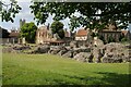
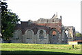
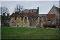
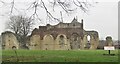
The impressive Abbey is situated outside the city walls and is sometimes missed by visitors. At the Abbey, you can also enjoy the museum and interactive audio tour.
BBC History Extra write:
"Before you leave, be sure to see the graves of the Saxon kings. These were moved from their original sites by Norman builders and marked by modern tombs, as were the graves of the early abbots such as St Augustine.
"Close to the north wall is a standing stone which may have been used as a cross by St Augustine."
According to "Fen Lander" there are three standing stones.
You may be viewing yesterday's version of this page. To see the most up to date information please register for a free account.
")
")
")
")
Do not use the above information on other web sites or publications without permission of the contributor.
Nearby Images from Geograph Britain and Ireland:
©2021(licence)
![TR1557 : St Augustine's Abbey [6] by Michael Dibb](https://s1.geograph.org.uk/geophotos/07/09/13/7091341_aed2e03f_120x120.jpg)
©2022(licence)
©2008(licence)
©2012(licence)
©2020(licence)
The above images may not be of the site on this page, they are loaded from Geograph.
Please Submit an Image of this site or go out and take one for us!
Click here to see more info for this site
Nearby sites
Key: Red: member's photo, Blue: 3rd party photo, Yellow: other image, Green: no photo - please go there and take one, Grey: site destroyed
Download sites to:
KML (Google Earth)
GPX (GPS waypoints)
CSV (Garmin/Navman)
CSV (Excel)
To unlock full downloads you need to sign up as a Contributory Member. Otherwise downloads are limited to 50 sites.
Turn off the page maps and other distractions
Nearby sites listing. In the following links * = Image available
320m W 280° St Thomas's Well (Canterbury)* Holy Well or Sacred Spring (TR151578)
415m WNW 284° Sunwin's Well Holy Well or Sacred Spring (TR15015784)
441m WNW 292° St. Thomas Becket's Well Holy Well or Sacred Spring (TR150579)
686m NW 325° St Rhadegund's Bath Holy Well or Sacred Spring (TR150583)
694m W 273° Museum of Canterbury* Museum (TR1472257767)
743m WSW 241° Dane John Mound* Artificial Mound (TR14785737)
2.5km W 280° Black Prince's Well* Holy Well or Sacred Spring (TR129581)
2.9km ENE 67° Fordwich Paleolithic Site Not Known (by us) (TR180590)
3.4km ENE 58° Our Lady's Well (Fordwich) Holy Well or Sacred Spring (TR18225970)
3.8km W 270° Bigbury Camp* Hillfort (TR116576)
3.9km SSE 150° Bridge Iron Age Settlement* Ancient Village or Settlement (TR175545)
4.2km SSW 212° Iffin Wood Bowl Barrow Round Barrow(s) (TR13335407)
4.3km S 180° Whitehill Wood Barrow Round Barrow(s) (TR156535)
4.7km ESE 108° Bekesbourne* Holy Well or Sacred Spring (TR20005646)
4.8km ENE 79° Arrianes Well Holy Well or Sacred Spring (TR201589)
5.3km SE 144° Hanging Hill Barrow Cemetary Barrow Cemetery (TR18725363)
5.9km SE 142° Barham Downs Barrow Round Barrow(s) (TR19295324)
6.0km SSE 166° Gorsley Wood Barrows Round Barrow(s) (TR17095201)
6.1km SE 144° Bishopsbourne Barrows Barrow Cemetery (TR19225296)
6.3km S 171° Gorsley Wood Mound Artificial Mound (TR167516)
6.6km NNW 338° Clowes Wood Barrows* Round Barrow(s) (TR12746378)
6.9km WSW 251° Pilgrims Way 9 Ancient Trackway (TR090552)
7.4km S 175° Bursted Wood Barrow Round Barrow(s) (TR16345036)
7.6km SW 214° Mounts Wood Barrow* Round Barrow(s) (TR11455126)
7.9km SW 231° Denge Wood Earthworks Misc. Earthwork (TR095525)
View more nearby sites and additional images


 We would like to know more about this location. Please feel free to add a brief description and any relevant information in your own language.
 Wir möchten mehr über diese Stätte erfahren. Bitte zögern Sie nicht, eine kurze Beschreibung und relevante Informationen in Deutsch hinzuzufügen.
 Nous aimerions en savoir encore un peu sur les lieux. S'il vous plaît n'hesitez pas à ajouter une courte description et tous les renseignements pertinents dans votre propre langue.
 Quisieramos informarnos un poco más de las lugares. No dude en añadir una breve descripción y otros datos relevantes en su propio idioma.